
River Adur facts for kids
Quick facts for kids Adur |
|
|---|---|

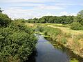
The Adur, downstream from Wineham Bridge
|
|
| Other name(s) | Beeding River, Bramber Water, Sore - all archaically |
| Country | England |
| Region | Sussex |
| Physical characteristics | |
| Main source | Western Adur Slinfold |
| River mouth | English Channel Shoreham-by-Sea |
| Length | 20 mi (32 km) |
| Basin features | |
| Tributaries |
|
The River Adur is a river in Sussex, England. It is about 20 miles (32 km) long. The river gives its name to the Adur district in West Sussex.
Long ago, large ships could sail far up the river to Steyning. Steyning was an important Saxon port. But by the 11th century, the lower part of the river became filled with mud and sand. This meant ships could no longer reach Steyning. So, the port moved closer to the sea, to Shoreham-by-Sea, where the water was deeper.
Contents
Where Does the River Adur Flow?

The River Adur actually starts as two separate parts. These are called the Western Adur and the Eastern Adur. They join together about 2 kilometers (1.2 miles) west of Henfield.
The Western Adur's Journey
The Western Adur begins its journey in a place called Slinfold. From there, it flows around Coolham. Then it goes through Shipley, where another stream, Lancing Brook, joins it. The river then continues towards West Grinstead and Knepp Castle.
The Western Adur is affected by the tides from the sea. The tide reaches as far north as Bines Bridge, which is near Bines Green. This spot is south of West Grinstead.
The Eastern Adur's Journey
The Eastern Adur starts at Ditchling Common in East Sussex. It then flows into West Sussex. Near Twineham, another important stream joins it.
At Shermanbury, the Cowfold Stream adds its water to the Eastern Adur. The normal point where the tide stops is just below Shermanbury Church. However, there is a small wall, called a weir, just before the Eastern and Western Adur meet. This weir means that only the very highest tides can reach this far up the river.
In the early 1800s, boats could travel up to Mock Bridge. This is where the A281 road now crosses the Adur.
Where the Two Branches Meet
West of Henfield, the two parts of the river, the Western and Eastern Adur, finally come together. From there, the river flows between Upper Beeding and Bramber. It then passes by Coombes.
The river then goes through a gap in the South Downs hills, near Lancing College. Here, the Ladywell Stream flows into the Adur. The river continues its path until it reaches the English Channel at Shoreham-by-Sea.
Today, the mouth of the Adur, where it meets the sea, is about 2 miles (3 km) away from the center of Shoreham town. This is because of something called longshore drift. This is when sand and shingle are moved along the coast by waves.
Part of the Adur's watercourse is also used by the Baybridge Canal.
Images for kids
-
The Adur, downstream from Wineham Bridge
