
Mount Caburn facts for kids

Mount Caburn is a famous hill in East Sussex, England. It stands about 1.6 kilometers (1 mile) east of Lewes. This hill is 146 meters (480 feet) tall. It overlooks the village of Glynde. Mount Caburn is part of the South Downs hills. A small river, the Glynde Reach, separates it from the main hills.
Contents
What is the Mount Caburn Fort?
At the top of Mount Caburn, you can find the remains of an ancient fort. People from the Iron Age built it long ago. Archaeologists have dug up this fort many times. They have found many interesting things there. In fact, it might be one of the most dug-up sites in Britain!
Scientists studied old plant remains from the area. They found that before 2000 BC, the hill was covered in dark yew trees. Very few ancient tools or items from before the Bronze Age have been found. This suggests that people didn't live there permanently back then.

How Was the Fort Built?
The top of the hill was first enclosed around 400 BC. This was in the middle of the Iron Age. Builders dug a deep, V-shaped ditch. They also made a bank from the dug-out dirt. The ditch was about 8 meters (26 feet) wide at the top. It was also 2.7 meters (9 feet) deep. This enclosed an area of about 1.9 hectares (4.7 acres).
For a long time, people thought this enclosure was a military fort. They believed it was built for defense. However, recent digs suggest something different. Some archaeologists now think it was a religious place. They believe it was not mainly for fighting or farming. They point to the small pits and the weak walls.
What Did They Find Inside?
There are over 140 pits on Mount Caburn. Some are round, some are triangle-shaped, and some are rectangular. Each pit was full of interesting items. These included weapons, tools, and pottery. They also found coins, grinding stones, and human and animal bones.
Archaeologists believe these items were not just trash. They think they were placed there on purpose. Many seem to have been part of religious ceremonies. The northeast corner of the enclosure seemed very important. Most of the valuable items were found there.
Later Changes to the Fort
Outside the first wall, on the north side, there is a very large ditch. This side was the easiest to attack. People used to think this outer ditch was a new defense. They thought it was built later in the Iron Age. Perhaps it was made to protect against the Romans.
But new excavations have shown this is not true. They found Roman-British pottery in the ditch. This means the outer ditch was built much later. It might have been a Saxon defense against Viking raids.
How Mount Caburn Was Used Over Time
Mount Caburn has only been used now and then since the big northern ditch was built. People lived there during the Norman Conquest. They also used it during the time of King Stephen.
During the Roman period, many sheep grazed on Caburn. The hillsides around it had many rectangular fields for farming. Later, the hill probably became wild again. But by the time of the Norman Conquest, sheep were grazing there a lot. The hillsides were also plowed into long strips. You can still see these old Roman fields and medieval strips today.
Over the centuries, sheep farming became the main activity. A famous sheep breeder named John Ellman raised his special Southdown sheep here.
During the Second World War, soldiers dug trenches on Caburn. They also built a position for a Bren gun. This was part of a defense line against a possible invasion.
Protecting Mount Caburn's Nature
Mount Caburn is now a protected area. It is part of the Lewes Downs SSSI. This means it's a special place for nature. The Mount Caburn National Nature Reserve was created in the 1980s. It is also a Special Area of Conservation. This is because it has beautiful chalk grassland with many orchids.
Caburn is special because its steep slope faces south. This helps certain plants grow. It has the largest number of burnt-tip orchids in Britain. You can also find the rare small-leaved sweet-briar here. Other orchids like the fragrant and pyramidal orchids also grow there.
Many interesting insects live on Caburn. These include the Adonis and chalkhill blue butterflies. You might also see the rare forester moth. Birds like stonechats live in the bushes. Other songbirds like blue tits are also present. You can often see herring gulls and carrion crows flying overhead. Hundreds of domestic sheep graze the area.
Mount Caburn in Art and Stories

Mount Caburn has appeared in many stories. In books, it is sometimes called Wealden Hill. It is a big part of novels by John Whitbourn. These include The Royal Changeling.
Mount Caburn also appears in a children's story. It's called Elsie Piddock Skips in Her Sleep. This book was written by Eleanor Farjeon in 1937. The hill is also mentioned in a poem by Rudyard Kipling.
What's in a Name?
The hill has only been called Mount Caburn since the late 1700s. No one is completely sure where the name comes from.
- Some people thought it came from "Caer Bryn." This is Welsh for "Stronghold hill." But many now think this is not correct.
- Another idea is that it was first called "Calde burgh." This is Old English for "Cold Fort." This name was used in 1296. Then, in the late 1700s, it might have been called Mount Carbone.
- Some local stories say it was called Carber in the 1700s. Before that, it was called Calborough Hill.
Images for kids
-
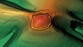
A 3D view of Mount Caburn.

