Ditchling Beacon facts for kids
Quick facts for kids Ditchling Beacon |
|
|---|---|
Northward view from the summit of Ditchling Beacon, looking towards Hassocks and Burgess Hill. 27 October 2006.
|
|
| Highest point | |
| Elevation | 248 m (814 ft) |
| Prominence | 213 m (699 ft) |
| Parent peak | Leith Hill |
| Listing | Marilyn, County Top |
| Geography | |
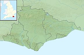
| Location | South Downs, England |
| OS grid | TQ331130 |
| Topo map | OS Landranger 198, Explorer OL11 |
Ditchling Beacon is a famous hill in south-east England. It's the third-highest point in the South Downs area. Only Butser Hill and Crown Tegleaze are taller. Ditchling Beacon is a big chalk hill. It has a very steep northern side. This side is covered with open grassy areas where sheep often graze.
The hill is located just south of the village of Ditchling. It's also to the north-east of the city of Brighton. It is the highest point in the county of East Sussex. A road goes up and over the northern side of the hill. It then goes down into the northern parts of Brighton. There are car parks at the top and bottom of the hill.
Many events use this steep road. Charity runs, sports races, and other events often go from London to Brighton. Ditchling Beacon is a challenging part of their route. It was even part of the 1994 Tour de France cycling race. The race organisers called it a "category 4" climb. Twenty years later, in 2014, it was part of the 2014 Tour of Britain cycling race.
Ditchling Beacon is also a special place for nature. It's part of the Clayton to Offham Escarpment biological Site of Special Scientific Interest. This means it's protected for its wildlife. About 24 hectares (60 acres) of the hill is a nature reserve. The Sussex Wildlife Trust helps to look after it.
A Hill with History
Ditchling Beacon stands out from the hills around it. It offers great views, especially to the north. This made it a perfect spot for defence a long time ago. People built a hill fort here during the British Iron Age. This was a very long time ago! The fort had a single bank and ditch for protection. It covered an area of about 5.5 hectares (13.6 acres).
Not much digging has been done to explore the fort. But we know it was an important place. People used the hill for centuries. There are old paths and tracks. Farmers have also ploughed the land over the years.
Getting to Ditchling Beacon
The only road to the top is Beacon Road. It starts in Ditchling village. Once you reach the top and start going down towards Brighton, it becomes Ditchling Road. Beacon Road connects to the B2116. This road links several villages near the South Downs.
The road up the northern slope is very steep. It climbs from 90 metres (295 feet) to 248 metres (814 feet) above sea level. This climb happens in just over 1.6 kilometres (one mile). The road has several sharp bends.
At the top, there's a small car park. The National Trust owns and manages this car park. They also own about 1.6 hectares (4 acres) of land on the hill. In 2005, a small fee was introduced for parking here.
From the summit, Ditchling Road goes downhill for about 4 kilometres (2.5 miles). It reaches the edge of Brighton at Hollingbury. The road then crosses the A27 Brighton Bypass. It continues as a busy road for more than 5 kilometres (3 miles) into the centre of Brighton.
You can also get to Ditchling Beacon by bus. Brighton & Hove runs special bus services. These buses go from Brighton city centre to Ditchling Beacon. Route 79 started in 2002. It often uses open-topped buses. At first, it only ran in summer. But it became so popular that it now runs in winter too.
Many paths cross the hill. A footpath and bridleway runs across the top from east to west. This path is part of the famous South Downs Way. Other paths go down the northern and southern slopes. They lead to villages like Ditchling, Westmeston, and Clayton. Walking along the main road itself is not safe.
If you prefer trains, you can get off at Hassocks station. From there, a path runs to Clayton. From Clayton, you can find several paths and bridleways. These lead up to Ditchling Beacon or other spots on the South Downs Way.
Plants and Animals
Ditchling Beacon is home to many different plants. You can see them especially in summer. Flowers and herbs that like chalky soil grow here. These include marjoram, thyme, and different types of orchid. The common spotted orchid is often seen. Some areas are also covered in scrubland.
Butterflies are very common on the hill. A special one is the Chalkhill Blue. This butterfly loves uncultivated chalk downland areas. You can often see sheep grazing in parts of the hill. This includes Ditchling Down, a large open area near the car park.
 | Misty Copeland |
 | Raven Wilkinson |
 | Debra Austin |
 | Aesha Ash |


