River Rother, East Sussex facts for kids
Quick facts for kids River Rother |
|
|---|---|

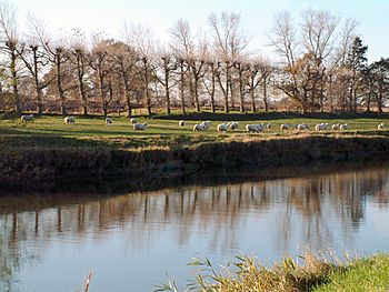
The Rother near Iden, in the Rother Levels
|
|

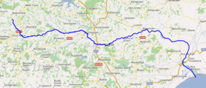
Course of the river Rother.
|
|
| Physical characteristics | |
| River mouth | Rye Bay 50°55′51″N 0°46′19″E / 50.930913°N 0.771844°E |
The River Rother flows for about 56 kilometers (35 miles) through the English counties of East Sussex and Kent. It starts near Rotherfield in East Sussex and ends at Rye Bay, which is part of the English Channel. Before 1287, the river's mouth was further east, at New Romney. But a huge storm changed its path, blocking its old exit to the sea.
The river was called the Limen until the 1500s. For its last 22 kilometers (14 miles), the river bed is lower than the high tide. A special gate called Scots Float sluice helps control the water levels. It stops salty sea water from coming in during high tides. It also keeps water in the river during summer to help the plants and animals in the nearby marsh. Below this gate, the river is affected by tides for about 6 kilometers (3.7 miles).
People have used the river for travel by boat since Roman times. Even today, small boats can go as far as Bodiam Castle. The river used to flow in a big loop around the northern side of the Isle of Oxney. But in 1635, it was moved to flow along the southern side instead.
Scots Float Sluice was built before 1723. Engineers tried to keep the river clear of mud, but it was hard for ships to use. In the early 1800s, the river became part of a defense line to protect England from France. Its lower part, along with a section of the River Brede, connected two parts of the Royal Military Canal. The Scots Float Sluice was rebuilt in 1844. In 1960, about 80 square kilometers (31 square miles) of the valley flooded. This led to a big project from 1966 to 1980 to improve the river. The river banks were made higher, and 20 pumping stations were added.
Different groups have managed the river over time. Today, the Environment Agency looks after it. What's special about the Rother is that it has been a "free river" since 1826. This means you don't need a special permit to use it. The land next to the river is managed by the Romney Marshes Area Internal Drainage Board. The Rother flows past or near villages like Etchingham, Robertsbridge, Bodiam, Northiam, and Wittersham.
Contents
What's in a Name? The River Rother's History
The name "Rother" is quite new, probably from around the 1500s. It comes from the village and area called Rotherfield, where the river begins. Rotherfield means 'open land for cattle' in Old English.
Before it was called the Rother, the river was known as the Limen. This is a Celtic word that means 'river'. In old Anglo-Saxon writings, it was sometimes called Limenea, where -ea also means 'river' in Old English. In the Anglo-Saxon Chronicle, it was called the River Lympne or Lymne. In the 1200s, people sometimes called it the River of Newenden.
How the River Rother Works
The Rother starts in the High Weald area of Sussex, high up at about 150 meters (490 feet) above sea level. It flows downhill quickly. Other rivers, like the River Dudwell and the River Darwell, join it. By the time it reaches Udiam, it's only about 2 meters (7 feet) above sea level.
The High Weald gets a lot of rain, about 890 millimeters (35 inches) each year. Most of the ground there doesn't let water soak in easily. This means rain quickly flows into the river and down to the sea. Because of this, the river valley often floods in winter. But in summer, if it's dry, the river can have very little water because there aren't many underground water sources.
Below Udiam, the river bed drops below sea level, and the lower river flows very slowly. The land around it has many canals and ditches. In winter, water is pumped from these ditches into the river to drain the land. In summer, water is moved the other way to help manage the marshland environment.
Controlling Water Levels with Scots Float Sluice
Scots Float sluice is about 6 kilometers (3.7 miles) from the river's mouth. It helps control the water levels. It's named after Sir John Scot(t), who made a harbor bigger there around 1480. The river below the sluice is tidal. The sluice closes when the tide rises to stop salt water from flowing upstream. In dry years, the sluice might stay closed for most of the summer to keep water in the marsh.
There's a special lock next to the sluice for boats to pass through. If there's heavy rain at the same time as a high tide, the river above the sluice acts like a huge storage area for floodwater. This helps prevent flooding further upstream. When there's a lot of water, some is also pumped from the river at Robertsbridge into Darwell Reservoir. This reservoir can hold a lot of water and provides drinking water for Hastings.
A Look Back: The River Rother's Past
Near its mouth, the River Rother doesn't follow its old path anymore. It used to flow across Romney Marsh and reach the sea at Dungeness. Many people say that in 1287, a huge storm, called the Great Storm, dumped a lot of stones and mud at the port of Romney and the river's mouth. The river then carved a new path, joining the River Brede and the River Tillingham near Rye, where they all flow into the sea.
However, some historians think this change happened even earlier, maybe a century before. Rye became an important port in the 1200s. Even though it's now a bit further from the sea, its harbor is still used by fishing boats and some commercial ships.
Early Changes and River Use
We know that boats used the river in Roman times. They could go as far as Bodiam and maybe even further upstream. Records show small boats reaching Etchingham during Saxon and Norman times. Stone for building Bodiam Castle was moved along the river in the 1300s. Iron was shipped from Newenden or Udiam in the 1500s. A century later, an iron storage building was put up at Udiam. Maytham Wharf served Rolvenden, and Small Hythe served Tenterden.
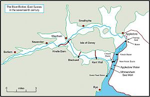
The Isle of Oxney is a higher area of land west of Appledore. The river used to flow around its northern side since the 1330s. A big problem was that tides brought a lot of mud into the river. In summer, the river flow wasn't strong enough to wash the mud away. This meant large areas of land were often flooded.
From the 1600s, people tried hard to drain these flooded lands. They built sluices to control the flow of tides and the river. These efforts weren't very successful. So, in 1631, they decided to move the river to flow through the southern levels. A new channel was built, and by May 1635, the river was flowing south of the Isle of Oxney. This new route made the river 8 kilometers (5 miles) shorter for boats. The old northern channel became known as the Reading Sewer.
In 1644, a very high tide flooded the area and broke through the new channel's walls. More work was done to build new sluices and walls to keep the sea out. By 1684, a new channel for the Rother, called the Craven Channel, was mostly finished. This channel ran along the southern edge of the valley.
In 1723, an engineer named John Reynolds was hired to fix Scots Float Sluice. He did more work on it in 1729 and rebuilt it in 1732 to add another outlet. New channels were dug in the 1730s so that all the water flowed through Scots Float.
Boats and Defense
The boats used on the river were called Rye sailing barges. They were about 14 meters (45 feet) long and 3.7 meters (12 feet) wide. In 1802, there were 16 barges on the river, up from only three ten years earlier. They mainly carried manure, fuel, and road stones. The river served places like Appledore, Newenden, Bodiam, and Small Hythe. Boats were pulled by men, as there was no path for horses.
In 1804, a famous engineer named John Rennie said that Scots Float Sluice was "very inconvenient" for ships.
Around this time, Britain was at war with France. To protect against a possible invasion, the Royal Military Canal was planned. This canal would connect to the River Rother at Iden. The river would then become part of the defense system, along with the River Brede. The canal was finished in 1809, but by then, an invasion seemed unlikely.
In 1826 and 1830, new laws were passed about the Rother Levels. These laws said that boats must be able to travel between Scots Float and Bodiam Bridge. They also made sure that all bridges had enough space (at least 1.5 meters or 5 feet) for boats to pass under. These laws also confirmed that the Rother was a free river, meaning no one had to pay tolls to use it.
The Rennie brothers, John and George, took over from their father. In 1830, they said the river was hard to use and flooded often. They thought the river channel was too winding, which caused mud to build up. Scots Float Sluice was rebuilt again in 1844.
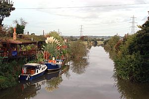
Iden Lock connected the Royal Military Canal to the river. The last commercial boat passed through it in 1909. After that, the lock was replaced by a sluice, stopping boats from going between the river and the canal. In the early 1900s, people enjoyed boat trips from Scots Float Sluice (then called Star Lock) to Bodiam Castle. Today, boats are moored on the lower river, and a ferry company offers trips from Newenden Bridge to Bodiam Castle.
Dealing with Floods
In 1960, the Rother Valley experienced major flooding. About 80 square kilometers (31 square miles) were underwater, and in some places, the water stayed for months. In 1962, a plan was proposed to Parliament to improve the river banks and build a new sluice and lock near Rye to stop tidal flooding. However, this plan didn't become law.
Instead, the Rother Area Drainage Improvement Scheme started in 1966 and finished in 1980. This project raised the floodbanks along much of the river. In some areas, like the Wet Level, the banks were not raised as much. This allows these areas to store floodwater when the river is full and the tide is high. The project also installed 20 pumping stations. These stations use special pumps to lift water from the low-lying marshes into the river.
Who Looks After the River?
Many different groups have been in charge of the River Rother over time. In the past, there were the Rother Levels Commissioners of Sewers and the Rye Harbour Commissioners. In 1872, the Board of Conservators for the River Rother was created to protect fish. By the early 1900s, things were confusing because many groups had overlapping duties.
In 1930, a new law called the Land Drainage Act 1930 tried to fix this. It created 47 catchment areas, each with a Catchment Board to manage it. The Rother and Jury's Gut Catchment Board was formed. Later, in 1950, larger River Boards took over. The Rother became part of the Kent River Board.
More changes happened over the years. In 1964, responsibility went to the Kent and Sussex River Authorities. Then, in 1974, single authorities managed both drinking water and river drainage. Finally, in 1996, the National Rivers Authority was replaced by the Environment Agency.
The Environment Agency now manages the river's drainage and water quality. It's unique that the Rother is a "free river," meaning you don't need a license to use it, even though the Environment Agency oversees it. The Environment Agency also acts as the harbor authority for Rye Harbour, which is also unusual.
The Environment Agency handles flood control for "main rivers" and water quality for all waterways. Other watercourses are managed by Internal Drainage Boards (IDBs). The Rother is considered a main river below Mayfield. Many IDBs have joined together to cover larger areas. The Romney Marshes Area IDB manages about 354 kilometers (220 miles) of drainage ditches and waterways. Most of the pumping stations that move water from these ditches into the Rother are owned by the Environment Agency.
The River Rother's Journey
The River Rother starts from several springs on the southeastern side of Cottage Hill near Rotherfield in East Sussex. The top of the hill is about 199 meters (653 feet) above sea level. The springs are found at lower heights. Another river, a tributary of the River Medway, starts on the other side of the same hill and flows in the opposite direction.
The Rother flows southeast, collecting water from other streams. It reaches the western edge of Mayfield, where the A267 road crosses it. Near this bridge is the site of Woolbridge Furnace, an old monument.
The river curves east along the southern edge of Mayfield. It passes a sewage works and goes under an old railway bridge and a road at St Dunstan's Bridge. A small river joins from the south, which once powered Moat Mill. The mill house is from the 1600s, and the mill building is from the 1700s. It's now a house, but most of the mill machinery is still there.
Two more small rivers join the Rother, one from the north and one from the south. Then, a small road crosses at Scotsford Bridge. The river drops below 45 meters (148 feet) soon after. The next bridges are Turks Bridge and Bivelham Forge Bridge. Tide Brook joins from the north. Witherenden Mill, an old mill house, is below this junction. It has two old oasthouses (buildings for drying hops) and a granary. The railway line, which followed Tide Brook, now runs next to the river as it goes east, passing north of Burwash.
After Crowhurst Bridge, the railway crosses to the south bank. Near Etchingham railway station, the River Limden joins from the north, the A265 road crosses, and the River Dudwell joins from the southwest. Both the railway and the river turn south to reach Robertsbridge. Another small river, which flows from near a gypsum mine at Brightling, turns south and runs next to the Rother before joining it in Robertsbridge. There are many channels here, as the River Darwell also joins. There used to be a mill nearby called Hodson's Mill, but it burned down in 1902.
A little further east, the old Abbot's House from the former Cistercian Abbey at Robertsbridge stands on the south side of the river. The Abbey was founded in 1176. The house was built between 1225 and 1250 and changed over the years.
The river turns northeast, passing under an old railway bridge. It drops below 5 meters (16 feet) to reach Bodiam. A local road crosses the river at Bodiam Bridge. South of the bridge is the site of an old Roman-British settlement.
Beyond Bodiam Bridge is Bodiam railway station, the end of the Kent and East Sussex Railway line since 2000. On the north bank of the river is Bodiam Castle, built around 1385. Lord Curzon restored the castle ruins in 1919 and gave them to the National Trust six years later. The castle and its grounds, which include a millpond and a Second World War pillbox, are important historical sites.
For the last 22 kilometers (14 miles) from Bodiam to the sea, the river bed is below the high tide level. Many drainage ditches cross the valley floor. The river has raised banks, with sluices and pumping stations along them. These help drain water from the low-lying land into the river. The Kent Ditch joins on the northern bank and forms the border between Kent and East Sussex. After this point, the border runs along the middle of the river.
At Newenden, Newenden Bridge carries the A28 road over the river. It was built in 1706 with three arches. Northiam is just to the south. The river loops south, going under the Kent and East Sussex Railway, into an area called the Rother Levels. The county border now follows a small channel to the north. This was the main river channel before 1635. The border joins the Hexden Channel near Maytham Wharf and then rejoins the river. Next, Potman's Heath Channel joins.
A short channel splits into Newmill Channel and Reading Sewer a little further north. A public footpath follows the eastern bank of Potman's Heath Channel and continues along the north bank of the river to Blackwall Bridge. Here, it becomes part of the Sussex Border Path, a long walking trail that follows the county border.
The low-lying land the river passes through is called the Rother Levels. Soon after New Bridge carries Wittersham Road over the river, the channel turns south. It runs along the eastern edge of Walland Marsh. The Military Road, built along the Royal Military Canal, crosses to the western bank of the river just before Iden Lock. This is the disused entrance to the canal. The lock has a sluice that controls water levels in the canal. In summer, water is pumped from the river into the canal to water the marshes.
The Military Road continues to follow the west bank, while the Saxon Shore Way footpath follows the eastern bank. Next is Scots Float Lock, and below it, the river is tidal. As it gets closer to the eastern edge of Rye, a fixed bridge carries the Marshlink railway line over it. This bridge was put in place in 1903, replacing an older swing bridge from 1851. Monk Bretton Bridge carries the A259 New Road. Below that, the Rother is joined by the River Brede at the southern edge of Rye. The river channel here is quite wide and is known as Rye Harbour. There's also a village called Rye Harbour at the southern end of this wide section.
In 1874, there was a wharf on the river with a railway line used to collect shingle. By 1909, the wharf was replaced by a landing stage further downstream, also served by the railway. As the river nears the sea, a Martello tower stands to the west. It was built in 1806 to protect against French invasion. It's Tower number 28, one of many built at that time. Nearby is an Inshore Rescue station, run by the Royal National Lifeboat Institution. The river then flows into Rye Bay, which is part of the English Channel.
How Clean is the Water? River Rother Water Quality
The Environment Agency checks the water quality of river systems in England. Each river gets an overall "ecological status," which can be high, good, moderate, poor, or bad. This status is based on things like the number and types of invertebrates (bugs), angiosperms (plants), and fish. They also check "chemical status," which compares chemical levels to safe limits. Chemical status is either good or fail.
Here's how the River Rother system's water quality was in 2016:
| Section | Ecological Status | Chemical Status | Overall Status | Length | Catchment | Channel |
|---|---|---|---|---|---|---|
| Upper Rother Five Ashes to Coggins Mill Stream | Moderate | Good | Moderate | 10.8 miles (17.4 km) | 15.04 square miles (39.0 km2) | |
| Rother between Coggins Mill Stream and Etchingham | Moderate | Good | Moderate | 7.3 miles (11.7 km) | 9.09 square miles (23.5 km2) | |
| Socknersh Stream | Good | Good | Good | 5.7 miles (9.2 km) | 3.92 square miles (10.2 km2) | |
| Limden | Poor | Good | Poor | 4.0 miles (6.4 km) | 6.77 square miles (17.5 km2) | |
| Kent Ditch | Poor | Good | Poor | 9.9 miles (15.9 km) | 10.84 square miles (28.1 km2) | |
| Hexden Channel | Poor | Good | Poor | 15.9 miles (25.6 km) | 20.10 square miles (52.1 km2) | |
| Lower Rother from Etchingham to Scott's Float | Moderate | Good | Moderate | 30.2 miles (48.6 km) | 55.51 square miles (143.8 km2) | heavily modified |
| Rother | Moderate | Good | Moderate | heavily modified |
The main reasons why the water quality isn't "good" are sewage (waste water) being discharged into most of the river and the physical changes made to the lower part of the river.
Places of Interest Along the Rother
| Point | Coordinates (Links to map resources) |
OS Grid Ref | Notes |
|---|---|---|---|
| Source near Rotherfield | 51°02′10″N 0°13′13″E / 51.0362°N 0.2202°E | TQ557286 | One of several starting points |
| A267 Bridge, Mayfield | 51°00′51″N 0°14′37″E / 51.0141°N 0.2437°E | TQ574262 | |
| Turks Bridge | 51°00′35″N 0°19′21″E / 51.0098°N 0.3226°E | TQ630259 | |
| Junction with Seller's Brook | 51°00′35″N 0°22′46″E / 51.0097°N 0.3794°E | TQ670260 | |
| Etchingham Railway Bridge | 51°00′49″N 0°25′24″E / 51.0137°N 0.4233°E | TQ700266 | |
| Junction with River Limden | 51°00′40″N 0°26′38″E / 51.0112°N 0.4440°E | TQ715263 | |
| Junction with Glottenham Stream | 50°59′20″N 0°28′56″E / 50.9889°N 0.4821°E | TQ742239 | Robertsbridge area |
| Bodiam Bridge | 50°59′59″N 0°32′24″E / 50.9996°N 0.5399°E | TQ783253 | Where boats can go up to |
| Junction with Kent Ditch | 51°00′12″N 0°34′17″E / 51.0034°N 0.5715°E | TQ805258 | |
| Maytham Wharf | 51°01′04″N 0°39′41″E / 51.0178°N 0.6614°E | TQ867276 | Now on Hexden Channel |
| Iden Lock, Royal Military Canal | 50°59′12″N 0°45′27″E / 50.9866°N 0.7574°E | TQ936244 | |
| Scots Float Lock | 50°58′12″N 0°45′03″E / 50.9699°N 0.7508°E | TQ932225 | |
| Junction with River Brede | 50°56′59″N 0°44′22″E / 50.9498°N 0.7394°E | TQ925202 | Rye town |
| Mouth into Rye Bay | 50°55′41″N 0°46′29″E / 50.9280°N 0.7746°E | TQ950179 | Where it meets the English Channel |
 | Victor J. Glover |
 | Yvonne Cagle |
 | Jeanette Epps |
 | Bernard A. Harris Jr. |


