River Tillingham facts for kids
Quick facts for kids Tillingham |
|
|---|---|

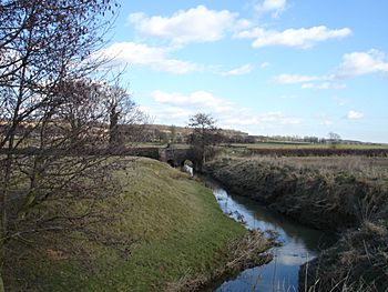
The river at Beckley
|
|
| Physical characteristics | |
| Main source | East Sussex |
| River mouth | River Brede Rye, East Sussex 0 m (0 ft) 50°56′49″N 0°43′54″E / 50.946958°N 0.731703°E |
The River Tillingham flows through the county of East Sussex in England. It joins the River Brede and the eastern River Rother near the town of Rye. For many years, a special gate called a sluice controlled the river's entrance. The river also powered an iron works that made cannons and later a water mill. The lower part of the river was important for building ships for a long time.
Contents
River Tillingham History
The River Tillingham used to flow differently a long time ago. During the Roman period, it flowed into a wide area of islands and salt marshes. It did not join the River Rother's estuary back then.
The 1200s were a tough time with very bad weather. Old Winchelsea, a town built on a shingle mound, was often flooded. After a big flood in 1271, a new town was built in 1280. This new town was on a hill near Iham, just south of the Tillingham.
In 1287, a huge storm changed things even more. It blocked the mouth of the River Rother. The Rother then found a new way to the sea near Rye. Here, it joined the Tillingham and the River Brede.
People tried to change the rivers in 1596. They tried to make the Rother flow around Rye to join the Tillingham. This project was very expensive and did not work well. The Rother went back to its old path by 1610.
Another big effort to control the rivers started in 1723. A new channel was planned from the Brede to the sea. This channel, called the New Harbour, opened in 1787 after 63 years of work. But it caused huge floods that autumn. So, after only four months, the New Harbour was closed. The old channel from Rye to the sea was reopened.
A special gate, called a navigable sluice, was built on the Tillingham in 1786. It was near Strand Quay. This sluice stopped salt water from flowing upstream. It also helped clean the river channel below it. At the same time, places for boats to load and unload were built further up the river.
It is not fully clear how the sluice was used. Some old maps say tides only reached the sluice. But later maps say tides flowed much further upstream when the gates were open. Most boat travel on the Tillingham stopped in 1928. This was when the old sluice was replaced with a new lifting gate.
Shipbuilding on the Tillingham
Shipbuilding has been happening in Rye since at least 1223. Many companies built ships on the lower parts of the Tillingham. In the early 1800s, firms like Harvey and Staffell built small sailing ships. Later, James and Henry Hoad built and operated their own ships.
The Rother Iron Works built steam tugs and trawlers in the 1880s. W E Clark built river barges in the 1890s. G and T Smith built ketches and smacks until World War I. During the First World War, they built two steam fishing boats. They also built special floating platforms for the Second World War. These platforms were used to find and explode magnetic mines. They also built eight minesweepers, which are ships that clear mines.
H J Phillips started his shipyard in 1913. His company kept building and fixing boats through two world wars. They worked on boats for fishing and for fun. Even in 2000, smaller shipyards were still working in Rye.
River Tillingham Route
The River Tillingham starts from two springs near Staplecross. This is a small village in Ewhurst, East Sussex. Both springs are high up on a hill. One spring is by the B2165 road, and the other is by Beacon Lane. Once they join, the river flows mostly to the east.
The river passes under two small roads, Ellenwhorne Lane and Watts Palace Lane. Other small streams join it here. Watts Palace Cottage, a very old timber-framed house, stands near the bridge. The river continues to drop in height as it flows. More streams join it before it reaches Arnold Bridge on the A28 Northiam Road. Very old timber-framed buildings are found on both sides of the river here.
Just before the next bridge is Beckley Furnace Farm. From 1578 to 1770, this was an iron works. It made cannons for the Royal Navy. The iron works used water power to make air blow into its furnaces. But it could not compete with newer factories that used coal. After the iron works closed, a watermill was built there. This mill burned down in 1909.
The river flows southeast to Hundredhouse Bridge. By the time it passes Billingham Wood, it is very low. The valley floor opens up here, with many drainage ditches. The river then turns northeast for a short time. It passes some lakes near Marley Farm, which used to be as far as boats could go.
The river then makes a big loop. A part of Rye was built on this loop after the Second World War. As the river enters Rye, it goes under Ferry Road. It also passes under a bridge for the Marshlink railway line. A smock mill (a type of windmill) from the 1930s is beside the railway bridge. The old mill there had burned down in 1930.
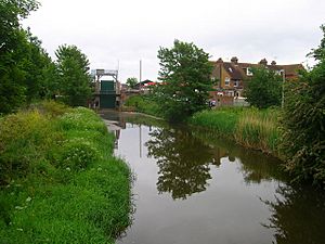
The Tillingham Sluice is just before the last bridge. This bridge carries the A259 Winchelsea Road over the river. Below the sluice is Strand Wharf. The Tillingham then joins the River Brede. Both rivers flow through the Rock Channel to meet the River Rother. Finally, they all flow out to the sea.
In 1872, there was a gasworks on the north bank of the river near the sluice. The area below was called The Quay. There was a Custom house and a shipyard there. Near where the Tillingham joined the Brede, there was a large timber yard. Another shipyard was on the Rock Channel.
By 1898, there were more timber yards below the sluice. The Custom House had moved. By 1907, a mill was described as a corn mill. Some timber yards became allotment gardens (small plots for growing food). By 1929, these areas had become housing. But a new timber yard appeared near the Brede junction. By 1971, The Quay had roads and warehouses. But shipyards were still active on the Rock Channel.
River Water Quality
The Environment Agency checks the water quality of rivers in England. Each river gets an overall "ecological status." This status can be high, good, moderate, poor, or bad. This rating looks at things like the types of invertebrates (bugs), plants, and fish in the water. They also check the "chemical status," which compares chemical levels to safe limits. Chemical status is either good or fail.
Here is the water quality of the River Tillingham in 2016:
| Section | Ecological Status | Chemical Status | Overall Status | Length | Catchment |
|---|---|---|---|---|---|
| Tillingham | Poor | Good | Poor | 11.6 miles (18.7 km) | 17.85 square miles (46.2 km2) |
The river's quality is not as good as it could be for a few reasons. These include wastewater from treatment plants and pollution from farms. Also, the river channel has been changed for drainage and flood protection. This makes it harder for fish to move freely in the river system.
Places to See Along the River
| Point | Coordinates (Links to map resources) |
OS Grid Ref | Notes |
|---|---|---|---|
| Source at Staplecross | 50°58′16″N 0°32′09″E / 50.9712°N 0.5358°E | TQ781221 | |
| Watts Palace Lane bridge | 50°57′34″N 0°34′10″E / 50.9594°N 0.5694°E | TQ805209 | |
| A28 Arnold Bridge | 50°57′33″N 0°35′50″E / 50.9591°N 0.5971°E | TQ824209 | |
| Beckley Furnace | 50°57′36″N 0°36′48″E / 50.9599°N 0.6134°E | TQ836210 | Old iron works and watermill site |
| Hundredhouse Bridge | 50°57′00″N 0°37′53″E / 50.9501°N 0.6313°E | TQ849200 | |
| Marley Farm | 50°57′12″N 0°41′56″E / 50.9533°N 0.6988°E | TQ896205 | Where boats used to stop |
| B2089 Ferry Bridge | 50°57′06″N 0°43′34″E / 50.9516°N 0.7260°E | TQ915204 | |
| Tillingham Sluice | 50°57′00″N 0°43′41″E / 50.9499°N 0.7280°E | TQ917202 | |
| Junction with River Brede | 50°56′49″N 0°43′54″E / 50.9470°N 0.7317°E | TQ919199 | |
| End of Rock Channel | 50°57′00″N 0°44′23″E / 50.9501°N 0.7397°E | TQ925203 | Where it meets the River Rother |
 | Laphonza Butler |
 | Daisy Bates |
 | Elizabeth Piper Ensley |


