
River Brede facts for kids
Quick facts for kids River Brede, East Sussex |
|
|---|---|

The river to the west of Winchelsea
|
|
| Country | England |
| Physical characteristics | |
| Main source | Netherfield, west of Battle, East Sussex 360 feet (110 m) |
| River mouth | River Rother, Rye sea level |
The River Brede is a river in East Sussex, England. It flows into the Rock Channel, which is a tidal part of the River Tillingham. From there, it joins the River Rother near Rye. The river gets its name from the village of Brede, which is located between Hastings and Tenterden.
Contents
What's in a Name? The River Brede's History
The River Brede is named after the village of Brede. This village sits on the north side of the river. Its name comes from an old English word meaning breadth. This is because the village looks out over the wide valley of the river.
Before the 1400s, the river was called the Ee or Ree. These names simply meant 'river' in old English. Later, a new channel was dug for the river. This new channel ran next to the old one. For many years, people called it the Channel. Eventually, it became known as the Brede.
A Journey Through Time: The River's Past
The Brede River flows through a wide valley. This valley is mostly marshland, which is very flat and low. Over many centuries, people have worked to manage the river and the land around it.
Protecting the Land from the Sea
In the 1100s and 1200s, people started building walls to protect the marshland from the sea. This work began near Cadborough Cliff and moved towards the river. Similar work happened further east near Broomhill. It seems that a large bank of shingle (small stones) protected the marshes from the sea. Many people involved in this work were from Flanders, a region in Europe.
The Great Storms and a New Wall
The weather got worse in the 1200s, with many more storms. A big storm in 1287-88 broke through the shingle bank. This caused the River Rother to change its path and flow into the sea near Rye. The old village of Winchelsea was flooded, and much of the protected marshland stayed underwater for 15 years.
Around this time, a long wall called the Damme was built across the Brede valley. It was about 1,100 yards (1,000 meters) long. This wall protected over 1,000 acres (400 hectares) of land from flooding. It also made it easier to cross the valley. There was a bridge in the middle and a sluice, which is a gate to control water flow. A dock called a flota was built on the eastern side. Ships used this dock to load firewood and timber to send to London and Europe.
Making the River Deeper
Later, another wall was built closer to Winchelsea. However, these walls reduced the amount of seawater that entered the valley with each tide. This meant the river started to fill up with silt (mud and sand). By 1357, it was hard for ships to reach Winchelsea.
To fix this, a new, deeper channel was dug for the river. This new channel was about 4.7 miles (7.6 km) long and 165 yards (150 meters) wide. It was finished between 1419 and 1442. This made the river navigable (easy for boats to travel on) all the way to Brede Bridge. A new quay (dock) was built there.
River Trade and Industry
The Brede River was used for boats even beyond Brede Bridge, reaching Sedlescombe. Lead was carried for Battle Abbey. In the Tudor period, an iron furnace was built in Brede. It made iron until 1766. Boats brought iron ore to the furnace and carried guns made from the iron back down the river. Groceries were also transported up the river.
Attempts to Build a New Harbour
The way to the sea from Winchelsea and Rye kept changing because of shingle and silt building up. Winchelsea's harbour was abandoned by the 1550s. By 1600, the future of Rye's port was uncertain. Camber Castle, which protected the harbours, was abandoned in the 1640s because the channels had changed too much.
In 1723, a new law allowed a new canal to be dug from the Brede near Winchelsea to the sea. This project was very expensive, costing over £13,000. Work began in 1724. A drawbridge was built over the existing Brede River channel to allow access to the new construction site.
The new canal was planned to be 20 feet (6.1 meters) deep at high tide. This would allow large ships to use it. It would have a scouring sluice (a gate to release water to clean the channel) and navigation gates. Work on the sluice and piers (structures extending into the sea) began in 1727. The project cost over £42,000 by the time it was finished.
The New Harbour's Short Life
Engineers suggested that the Brede, Tillingham, and Rother rivers should all flow into this new channel. A new channel was cut south of Rye. However, this new harbour didn't work well. The entrance still filled up with shingle and silt.
After a very wet autumn in 1787, the new harbour was abandoned. It had only been used for four months! The old route to the sea was reopened. The entrance lock to the Brede at Rye was built the next year. People in Rye were happy to have their "Ancient Harbour" back.
The Royal Military Canal
When the Napoleonic Wars with France began in 1803, there were worries about a French invasion. To defend England, Martello towers were built, and the Royal Military Canal was planned. This canal was a defensive waterway from Hythe in Kent to Cliff End in East Sussex. Part of this canal used the River Rother and the Brede River. By the time it was finished in 1809, the threat of invasion had passed.
Later River Use and Changes
In the 1800s, barges still used the Brede River. They could travel up to Brede Bridge. In 1903, when the Brede Valley Waterworks was being built, materials were brought by barge to a wharf near Brede Bridge. Coal for the waterworks continued to arrive by water until about 1928.
However, large barges could only reach Brede Bridge on certain days when the water was high enough. By the 1930s, draining the land was more important than river navigation. In 1934, the right to use boats on the river was officially removed. Boats continued to deliver fuel to the waterworks until 1935, when a road was built. Today, you can still use boats on parts of the river in winter. But in summer, a sluice called Udimore Sluice holds back water, which stops boats from using some areas.
The River's Path: Where the Brede Flows

The Brede River starts from several springs south of Netherfield. These springs are about 360 feet (110 meters) high. The small streams join together and flow southeast, then northeast. They pass under a minor road and the A2100 road. By this point, the river is already below 100 feet (30 meters) in height.
At Pond Bay, a stream called Rat Gill joins the river. The river then turns east and flows under a railway bridge on the Hastings Line. The River Line joins it at Whatlington. Other streams also join as it passes under the A21 and B2244 roads south of Sedlescombe. South of the river is the Pestalozzi International Village, which was set up after World War II to help children. The river channel now has drainage ditches on both sides.
Brede Waterworks and Beyond
A little further east is Brede Valley Waterworks on the north bank. It was built in the early 1900s. Some parts of it are listed buildings. The old engine house still has one of its original steam engines from 1904. A newer building from the 1930s has a pumping engine from 1940.
Before Brede Bridge, there is an old pumping station that used to pump water from drains into the river. An area of 60 acres (24 hectares) is being turned back into marshland. This will help bring back the natural waterside environment. Brede Bridge is a modern concrete bridge. It was built during World War II so tanks could cross it.
Beyond the bridge, Doleham Ditch joins from the south. The Marshlink railway line also turns east to follow the Brede Valley. The valley floor gets wider here. A network of drains keeps this area, known as the Brede Level, from flooding.
Towards Winchelsea and Rye
As the river passes north of Icklesham, the railway crosses to the north side of the channel. Another pumping station pumps water into the river from drains south of the river. Soon, the river reaches Winchelsea. Many parts of this town are protected as a Scheduled Ancient Monument.
Station Road, which leads to Winchelsea railway station, crosses the river at Ferry Bridge. The A259 Royal Military Road, built in 1805 as part of the defensive Royal Military Canal, crosses at Strand Bridge on the east side of town. Just past this bridge, the western part of the Royal Military Canal goes south towards Cliff End. This canal is also an ancient monument. The Saxon Shore Way footpath follows its eastern bank.
After two bends, just before the river turns sharply north, was the spot where the failed New Harbour canal joined. As the river goes towards Rye, there is a sewage treatment works on the east bank. You can also see the remains of Camber Castle. King Henry VIII built this castle in 1538, but it was abandoned in 1640 when the sea moved away. The castle and its grounds are a Scheduled Ancient Monument.
North of the castle is the Castle Water Nature Reserve. This 220-acre (89-hectare) site was bought by the Sussex Wildlife Trust in 1992. Gravel was dug here between 1935 and 1970. Now, it's a valuable wetland home for birds. Brede Sluice is actually a lock that leads into the Rock Channel. This channel was dug around the south side of Rye in the 1760s. At its end, the Brede River flows into the River Rother.
River Health: Water Quality
The Environment Agency checks the water quality of rivers in England. They give each river an overall "ecological status." This status can be high, good, moderate, poor, or bad. They look at things like the types of invertebrates (bugs), plants, and fish in the river. They also check the chemical status, which compares chemical levels to safe limits. Chemical status is either good or fail.
Here's how the Brede river system's water quality was in 2016:
| Section | Ecological Status | Chemical Status | Overall Status | Length | Catchment |
|---|---|---|---|---|---|
| Line | Moderate | Good | Moderate | 6.0 miles (9.7 km) | 8.04 square miles (20.8 km2) |
| Vinehall Stream | Good | Good | Good | 1.4 miles (2.3 km) | 1.39 square miles (3.6 km2) |
| Tributary of the Brede at Westfield | Good | Good | Good | 2.2 miles (3.5 km) | 5.06 square miles (13.1 km2) |
| Doleham Ditch | Moderate | Good | Moderate | 2.5 miles (4.0 km) | 6.31 square miles (16.3 km2) |
| Brede | Poor | Good | Poor | 19.9 miles (32.0 km) | 20.56 square miles (53.3 km2) |
The water quality is not as good as it could be for several reasons. These include sewage (wastewater) being released into the river and activities like quarrying (digging for stone). Also, barriers in the river stop fish from moving freely, and water being held back (impounding) affects the river's health.
Images for kids
-
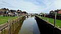
River Brede as it passes through Rye

