
Camber Castle facts for kids
Quick facts for kids Camber Castle |
|
|---|---|
| East Sussex, England | |

Camber Castle, seen from the north-west
|
|

Camber Castle
|
|
| Coordinates | 50°55′59″N 0°43′57″E / 50.93305°N 0.73248°E |
| Type | Device Fort |
| Height | 18 metres (59 ft) |
| Site information | |
| Owner | English Heritage |
| Open to the public |
Yes |
|
Listed Building – Grade I
|
|
| Official name | Camber Castle |
| Designated | 3 August 1961 |
| Reference no. | 1234738 |
| Condition | Ruined |
| Site history | |
| Materials | Yellow and grey sandstone, brick |
Camber Castle, also known as Winchelsea Castle, is a historic fort built in the 1500s. King Henry VIII ordered it built near Rye to protect England's coast from French attacks.
The very first part of the fort was a small, round tower built between 1512 and 1514. It stood overlooking the Camber, which was a busy place for ships, and the entrance to Rye Harbour. In 1539, when tensions with France grew, King Henry decided to make his coastal defenses much stronger. Camber Castle was rebuilt and made bigger over the next year. An engineer named Stefan von Haschenperg helped design the changes.
More work was done on the castle from 1542 to 1543 to fix some problems. The final result was a large, concentric fort. This means it had a central tower, called a keep, surrounded by four round towers, called bastions, and a round entrance tower. It was built using stone and brick.
The finished castle first had 28 large guns and a team of 28 soldiers, led by a captain. It might have been used in 1545 when a French fleet attacked the coast. However, the castle's usefulness didn't last long. The Camber and nearby harbors began to fill up with sand and mud, becoming too shallow for ships. The coastline also moved further away from the fort, leaving it inland.
Even before it was finished, the castle's design was becoming old-fashioned compared to newer European forts. Also, peace with France later in the century meant the fort wasn't needed as much. The castle stayed open until 1637, when King Charles I closed it. When the English Civil War started in 1642, much of the fort was taken apart by Parliament's forces. They did this to stop the King's supporters from using it.

By the 1700s and 1800s, the castle ruins became a popular spot for picnics. The famous painter J. M. W. Turner even painted it. There were ideas to turn the castle into a Martello tower (another type of fort) or a golf clubhouse, but these plans didn't happen. The castle was used during World War II, probably as a place to spot enemy planes early.
After the war, people became more interested in studying the castle's history. In 1967, the government took care of it, and then bought it in 1977. Today, English Heritage looks after Camber Castle. They worked hard to protect it from 1968 to 1994, and now visitors can explore it. The fort is special because it's one of the few "Device Forts" that hasn't been changed much. It's protected by UK law as a Grade I listed building.
Castle History
Early Years: 1500s – 1600s
Building the First Tower: 1512–1514

Camber Castle was built about 1.5 kilometres (0.93 mi) from the towns of Rye and Winchelsea. It overlooked a waterway called the Camber, where three rivers met. Rye and Winchelsea were part of the Cinque Ports, a group of towns that provided ships for the king's navy. However, by the 1500s, Winchelsea's harbor was already filling with mud, and Rye's harbor was starting to have similar problems. The Camber itself was also getting shallower, but it had become an important place for ships to anchor.
King Henry VIII came to power in 1509. He wanted to be stronger against France than his father had been. As tensions grew, Henry ordered a new artillery tower and a bridge to be built at Camber in 1512. This work cost about £1,309 and took two years. The tower was round, made of stone, 64 feet (20 m) across, and about 30 feet (9.1 m) high. It was built on a shingle point called Kevill Point. This tower helped control the Camber and Rye's port. It was not very big inside and probably didn't have a permanent group of soldiers living there.
Even though it was an artillery tower meant for big guns, it didn't have any at first. This meant it couldn't protect Rye from French ships that attacked in the 1520s. After many requests, some guns finally arrived around 1536. People also started to worry in the mid-1530s that the Camber might get too shallow to use as a harbor.
Expanding the Castle: 1539–1540

In 1539, the threat of invasion from France and Spain became very serious. King Henry ordered new defenses to be built all along England's coast. These were called the Device Forts. They were designed to hold large guns that could fire at enemy ships and stop them from landing. Camber Castle was greatly expanded as part of this plan, costing £5,660.
The first part of this expansion happened from 1539 to 1540. An engineer from Moravia, Stefan von Haschenperg, designed the fort. He was paid a good salary for his work on Camber and other forts. Local leaders helped manage the project. It was hard to find enough workers, and some had to be forced to help. More guns were sent to the castle even before it was finished. These were likely set up in temporary gun positions around the site.
First, the old tower was made stronger to become the castle's central keep. It could now hold guns on its roof. A gatehouse was built next to it. Four smaller towers, called stirrup towers, were added. A strong outer wall, called a curtain wall, was built around the castle, with bastions (strong towers) along it. Towards the end of 1540, the castle was changed quickly, perhaps because the King wanted it done fast. The outer wall was made taller, the gatehouse became a bigger entrance bastion, and secret underground passages were built. By the end of 1540, the castle had 17 soldiers and guns.
The new design was a concentric fortress. Von Haschenperg hoped it would be like the best forts in Italy, strong enough for heavy guns but low to the ground to protect against enemy fire. But problems quickly appeared. The design focused so much on defense that the guns couldn't easily shoot at enemy ships. Some firing angles were blocked, and the high water level caused dampness inside. Also, this design was different from other Device Forts and didn't quite fit the King's overall plan.
Fixing the Design: 1542–1543

Because of the problems with the first design, work started again on the castle in the summer of 1542. This was after the main invasion scare had passed, and it lasted until August 1543. King Henry himself might have decided to fix the castle. The cost of this second phase was much higher, around £10,000.
The new design was quite different from von Haschenperg's first one. The central keep and the stirrup towers were made taller, and their floors were raised. The outer wall was made stronger. The old bastions were completely removed, and four new, larger ones were built in their place. The old outer defenses were torn down. The keep's flat roof was changed to a sloped one, and the guns it had held were moved to the outer bastions. Even though the castle became slightly smaller, the new design had much more space for the soldiers to live.
However, even this improved design didn't use the newest ideas from Europe, like sharp-angled bastions. The round towers left "dead spots" where the guns couldn't fire. The high walls were an easier target, and it was still hard to move around inside the fort. In fact, one historian said the final design was even "more archaic" (old-fashioned) than the first. Von Haschenperg left England in 1544, facing complaints that he pretended to know more than he did.
Most of the stone for the castle came from tearing down old church buildings in Winchelsea. Stone was also bought from nearby quarries. Higher quality stone came from other parts of England and even from France. Wood came from local forests. Chalk was brought from Dover to make lime, which was used in building. Many bricks were bought, and even more were made nearby as the work continued. Metal and tiles were bought locally, along with a large crane for the project's dock.
How the Castle Was Used

By the time Camber Castle was finished, it was already a bit old-fashioned. Newer forts in Europe had sharper, angled towers, known as star forts. Still, Camber Castle was used as an artillery fort for the rest of the 1500s. In 1540, it had 24 soldiers, and after 1542, it had 28 soldiers and a captain. The castle had small openings for handguns, but it also relied on archers for defense from land attacks. For example, in 1568, it had 140 longbows and many arrows, probably for local soldiers to use in wartime.
The fort initially had between 26 and 28 large guns. These included powerful brass guns like demi-cannons and culverins, and iron guns like portpieces. Brass guns could fire faster and were safer than iron ones. It's hard to say exactly how far the guns could shoot, but some could reach targets over 1,600 metres (5,200 ft) away.
In July 1545, the French attacked nearby Seaford. Camber Castle might have been used against the French fleet then. But soon, mud began to block the entrance to the Camber, making it hard for ships to use. People complained to Parliament in 1548, and by 1573, people in Rye feared the Camber was ruined. By the end of the century, the harbor was unusable. The area also became less important for defense. Peace was made with France in 1558, and England's military focus shifted to Spain.
From 1553 onwards, the castle had 26 or 27 soldiers, including 17 gunners. By 1568, the gun platforms were in "utter Ruing and decay" (completely ruined). Repairs would cost about £60, but it's not clear if they were done. When tensions with Spain rose, Queen Elizabeth I spent £171 on repairs in 1584. In 1588, the year of the Spanish Armada, there was a plot to hand over the castle to French and Spanish soldiers, but it failed.
In 1593, there was another crisis with Spain. The English navy needed brass guns, so they were taken from forts like Camber. The castle still had guns, but the larger brass ones were replaced with smaller iron ones. In 1594, another survey said the fort needed £95 worth of repairs.
Later Years: 1600s – 1800s
Closure and Civil War
Camber Castle saw several changes in the early 1600s. In 1610, the number of soldiers was cut to 14, including only 4 gunners. This might have been to save money or because the types of guns changed. Around 1613-1615, the north and south bastions were filled in to create solid gun platforms. An earth bank, called the Rampire, was built against the south side of the castle. These solid platforms were cheaper to maintain. Longbows were no longer used in warfare and were replaced by arquebuses and muskets. In 1614, the castle had 46 of these new firearms.
By the 1620s, the fort was old-fashioned and too far from the sea to be useful. In 1623, people suggested closing it. King Charles I was told the castle was falling apart and was now about 2 miles (3.2 km) from the sea. Local towns wanted to keep it open, but in 1636, Charles ordered it to be torn down. The soldiers left in 1637, and the guns were removed.
When the English Civil War began in 1642, Camber Castle hadn't been fully closed and was being used to store royal weapons. The people of Rye supported Parliament. They agreed that the weapons should be moved to the town for safety. Parliament then started to take the castle apart over the next year. They removed the lead from the roof, blocked the gun openings, and destroyed the living areas. Because of this, Royalist forces couldn't use Camber Castle during the Second English Civil War in 1648.
The Castle as Ruins

After King Charles II returned to the throne in 1660, a survey found the castle in ruins. More and more visitors came to see the castle in the 1700s and 1800s. The north-east corner became a popular spot for picnics. In 1785, a writer named Francis Grose said the castle declined because the local harbors changed and because the Royal Navy became very strong. He also noted that the castle's design showed how basic military building was in England during the 1500s.
During the Napoleonic Wars, when France was a threat, an officer named John Brown checked the castle in 1804. He wanted to see if the central keep could be turned into a Martello tower, a popular type of round gun tower at the time. This plan didn't happen, but the government did improve other defenses along the coast. The painter J. M. W. Turner visited the castle between 1805 and 1807 and later painted it.
Modern Times: 1900s – Today

In the early 1900s, Camber Castle and the land around it were privately owned, but visitors could still go there. In 1931, there was an idea to turn the keep into a golf clubhouse, but it wasn't built. A research team visited the castle in 1935, and the first historical study of the fort was published two years later.
By the 1940s, the castle was mostly covered in rubble and dirt, with paths made by visitors over the years. During World War II, the British Army used the castle, possibly as an early warning site with anti-aircraft searchlights. Nearby, fake targets were set up to trick German bombers away from Rye. Trenches were dug in the north bastion, and soldiers might have trained around the castle.
After the war, people became more interested in archaeology (the study of old things). From 1951, the Ministry of Works started a long study of the Device Forts, including Camber. In 1962, an archaeologist named Martin Biddle did an early survey of the site. The next year, the ruins were closed for more detailed digging by the Ministry. Local schoolchildren and young offenders helped with this work.
The government took official care of Camber Castle in 1967. The next year, they began slowly restoring the castle to open it to the public. They focused on protecting the inner brick walls. More digs happened in the 1970s and early 1980s.
In 1977, the government bought the castle from its owners. English Heritage took control in 1984. In 1993, a plan was made to reopen the castle to visitors. This included a final review of all the archaeological work. The castle finally opened to the public again in 1994. As of 2015, you can visit the castle through guided tours organized by the Rye Harbour Nature Reserve. The site is protected under UK law as a Grade I listed building.
Castle Design and Location
The Landscape Around the Castle
Camber Castle now sits on the Brede Level, a wide, flat area of land between Rye and Winchelsea. It's about 1.5 kilometres (0.93 mi) from the sea. The land around it is flat and just above sea level, with many small ridges that show where the coastline used to be. To the east of the castle is Castle Water, a large gravel pit from the 1900s that is now a flooded nature reserve.
A 1.8-metre (5 ft 11 in) high earth wall runs around the south and east sides of the castle. This was probably topped with a stone wall and was meant to protect the castle from the sea, which was much closer back then. The remains of a raised path, which once connected the isolated castle to the mainland, lead a short distance to the south-west before disappearing. You can also see marks from holes dug to get materials for filling in the bastions in the early 1600s.
How the Castle Was Built


The three-story castle hasn't changed much since it was finished in 1544. It includes parts from all three building stages: 1512–14, 1539–40, and 1543–44. It no longer has a roof but still stands up to 18 metres (59.1 ft) tall. It covers 0.73 acres (0.30 ha), which is almost as big as the largest Device Fort, Deal Castle. The first tower was built from fine yellow sandstone. Later expansions used both yellow and grey sandstone, with special stone from France for details. The inner parts of the walls used local stone and boulders.
You would have entered the castle through the entrance bastion. The main part of this building was built in the second phase of work. It was first a square, one-story building, 15 by 10.5 metres (49.2 by 34.4 ft) across. Then it was extended forward by another 9 metres (29.5 ft) to form a round bastion. A third floor was added on top in the final building phase. Most of the inner walls are gone, but the ground floor rooms were likely used for managing the castle and perhaps as living areas for the deputy captain. The first floor would have been fancy rooms for the captain, with large windows, fireplaces, and a private toilet. Most of this floor is now destroyed. A special German stove, decorated with pictures of soldiers, was probably in the captain's rooms. Only small pieces of it remain.
In the center of the fort was the keep, built from the original round tower from 1512–14. About 6.7 metres (22 ft) of the old tower's walls were used in the new design. The original tower had ten gun openings at ground level in its 3.05-metre-thick (10.0 ft) walls, but these were blocked up in the second building phase. The keep originally had a low wall around its roof, which was flat but changed to a sloped design in the third phase. The ground floor was made of brick and had a brick and stone-lined well for water. The keep had two small fireplaces, but they weren't for cooking. The final version of the keep was probably not used for living. Windows were added to the first floor in the final phase. They weren't for guns, but they had bars and shutters, so they could be easily secured if attacked.
An underground, arched passage, only 1.9 metres (6 ft 3 in) high, ran around the outside of the keep. Similar covered passages led from it to each of the bastions; these passages are now ruined. A cobbled courtyard surrounded the keep, separating it from the outer defenses. There was another well in the north-west corner of the courtyard. Underground passages led from the entrance bastion to outside the castle walls. These might have been for soldiers to escape in an emergency or to attack an enemy force.
The outer part of the castle was protected by an eight-sided wall. This wall connected the four stirrup towers and bastions, which were the main defenses. This wall was first built in the second phase of work. Then, in the final phase, an extra 2.4-metre-thick (7.9 ft) outer layer was added. It originally had gun openings along each section and low walls on top. A two-story gallery, which provided spacious living areas for the soldiers, ran all the way around the inside of the wall. Only the ground floor of this gallery remains today. The gallery would have had windows facing into the courtyard. The Rampire earthwork, built in the early 1600s, covers parts of the south and south-east defenses. Here, the gun openings were blocked with stone when the earth was piled up inside the castle.
The four stirrup towers are two stories tall, 6 by 6.2 metres (19.7 by 20.3 ft) across inside, with 0.8-metre-thick (2.6 ft) walls. They are flat at the front and curved at the back. They would have had firing platforms on top, with gun openings inside so soldiers could fire into the courtyard if needed. The bastions built around the outside of these towers in the third phase are 19 metres (62.3 ft) wide inside and extend 12 metres (39.4 ft) from their stirrup tower, with 3.6-metre-thick (12 ft) walls. Most bastions had one gun room inside with a strong gun deck on top. However, the West Bastion was used as a kitchen and had two round ovens and a cooking range. The bastions would have been connected by a walkway on the wall and low walls, but these are now gone. The south stirrup tower and bastion are still partly buried because of the Rampire.
Images for kids
-
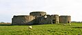
Camber Castle, seen from the north-west
-
Camber Castle in the dry landscape of the 2018 summer.
-
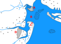
The Camber in the late medieval period. Key: A – Rye; B – the Camber anchorage: C – Camber Castle on Kevill Point; D – Winchelsea; dotted areas – sand dunes and banks
-
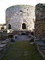
The keep, based on the original artillery tower
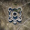
-
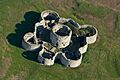
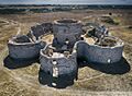
The castle's concentric design seen from the air
-

A replica 16th-century English bronze culverin (near) and an iron portpiece
-
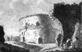
Engraving of the castle ruins in 1785
-
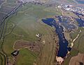
An aerial view of the castle (centre), with the River Brede (left), the modern Castle Water (right) and Rye Harbour (top right)
-
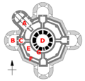
Plan of the castle: A – entrance basion; B – bastion; C – stirrup tower; D – keep; E – courtyard; F – gallery and octagonal wall; G – vaulted ring passage.
Black – initial 1512–14 work; grey – 1539–40 extensions; light grey – 1543–44 redevelopment -
Camber Castle from above in August 2018
