
River Rother, South Yorkshire facts for kids
Quick facts for kids River Rother |
|
|---|---|

The river at Staveley
|
|
| Country | England |
| Physical characteristics | |
| Main source | Pilsley, Derbyshire |
| River mouth | River Don, Rotherham |
| Length | 26.9 miles (43.3 km) |
The River Rother is a river in the northern part of England. It gives its name to the town of Rotherham and the Rother Valley area. The river starts near Clay Cross in Derbyshire. It flows north through Chesterfield, where it connects with the Chesterfield Canal. The Rother then goes through the Rother Valley Country Park and parts of Sheffield. Finally, it joins the River Don at Rotherham in Yorkshire.
For many years, starting in the 1880s, the river became very dirty. This was mainly because of coal mining and the towns that grew around it. The water became so polluted that almost nothing could live in it. By 1974, it was the dirtiest river in the whole River Don area. The pollution came from places that made coke (a type of fuel), from sewage plants that didn't clean water well, and from chemical factories.
Thankfully, a lot of money was spent to clean up the river. Sewage treatment plants were improved, and factories had to clean their waste before putting it into the river. Also, many of the old coke-making plants closed down. These changes helped the river get healthy again. Fish were put back into the river starting in 1994. By 1996, fish were living and reproducing on their own, and people could even start fishing there again!
A small part of the river in Chesterfield used to be used by boats. There are plans to make it navigable again as part of a new development. There are also ideas to use the river's path from Rother Valley Country Park to Rotherham for something called the Rother Link. This link would connect the Chesterfield Canal to the River Don Navigation. The lower part of the river is also managed to prevent floods. Special gates can control the water flow. When these gates are used, nearby low-lying areas (called washlands) usually flood instead of towns.
Contents
What's in a Name? The River Rother's Meaning
The name 'Rother' has an interesting history. The second part of the name, -duβr, comes from an old British language. It means 'water'. You can still see this in the Welsh word dwfr, which also means water.
The first part of the name, rö-, could mean 'great' in that old British language. Or, it could come from the word rūδ, which means 'red' or 'reddish-brown'. So, the River Rother's name might mean 'great water' or 'red water'.
The River's Journey: From Source to Sea
The River Rother starts at Pilsley near Clay Cross in Derbyshire. From there, it flows west for a short distance before turning north. The river's valley is shared with a railway line that crosses the river many times.
Before reaching Chesterfield, other streams join the Rother. These include the Red Lead Mill Brook, Birdholme Brook, and Calow Brook. The River Hipper also joins the Rother on the southern edge of Chesterfield.
The River in Chesterfield
In Chesterfield, a part of the river used to be navigable, meaning boats could use it. The Chesterfield Canal connected to the river here. This allowed boats to reach special docks on the river's western side. The first dock was near the Wharf Lane footbridge. Later, a new dock was built north of the Brimington Road bridge in 1890.
This part of the river is now part of a huge building project called Chesterfield Waterside. This project will create new homes and facilities on land that was once unused. A new, short section of canal is being built to create an island in the middle of the area. A new dock has also been built near where the 1890 one was, but it's not yet connected to the river.
Flowing North: Beyond Chesterfield
North of Chesterfield, between Chesterfield and Tapton, the river flows over a large weir (a small dam). The canal nearby is protected from floods by a special gate. The river and canal stay close as they flow north between New Whittington and Brimington. Here, the River Drone joins the Rother from the west.
At Old Whittington, both the river and canal turn east, then north again at Staveley. Further north, the River Doe Lea joins the Rother from the east. The river then flows past Eckington and Killamarsh.
Rother Valley Country Park and Beyond
The river then reaches the Rother Valley Country Park. Here, the river's path was largely created by people. The park itself is part of a flood defense system. The river was moved to run next to the railway while coal was mined from under the park between 1976 and 1981. After the mining stopped and the pit was filled, the river channel was rebuilt.
The visitor center at the park uses part of an old mill called Bedgrave Mill, built around 1100. This was one of the first mills known to be built on the River Don and its smaller rivers.
Continuing north, the river flows through parts of Sheffield, like Beighton and Woodhouse. Then it enters Rotherham districts like Catcliffe and Treeton. Finally, it meets the River Don at Ickles, Rotherham.
Some parts of the river used to be very polluted. When Rother Valley Country Park was being built, cleaner water had to be brought in from another stream (Moss Brook) to fill the park's lakes. However, with industries closing and the Environment Agency working hard, the River Rother's water quality has greatly improved. The river now has many coarse fish, and fishing clubs are growing along its banks.
There are plans for a new canal called the Rother Link. This canal would use part of the River Rother to connect the Sheffield and South Yorkshire Navigation to the Chesterfield Canal.
Controlling Floods: Protecting Communities

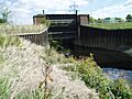
The Environment Agency manages the River Rother to help prevent floods in areas like Catcliffe and Rotherham. They do this using special gates called regulators and areas called washlands. Regulators hold back the river's flow. Washlands are low-lying areas next to the river that are allowed to flood when the water is held back. This helps make sure that floodwaters from the River Don pass through Rotherham before the Rother's water arrives. There are three main regulators: at Canklow, Woodhouse Mill, and Meadowgate.
Before 1958, flooding was a big problem near the lower parts of the river, especially in Beighton, Catcliffe, Treeton, and Woodhouse Mill. When a plan to improve the River Rother was first suggested in 1958, experts realized that if they just made the river wider, the floodwaters would reach the River Don too quickly. This would cause more flooding in Rotherham. So, the plan included creating and managing washlands to hold back extra water during floods.
How Regulators Work
The first regulator was built at Woodhouse Mill. It's a vertical gate that can be lowered to block the river. When it closes, the Woodhouse Mill washlands nature reserve floods. There are no floodbanks between the river and the reserve, so it floods quickly.
The Canklow regulator is also a vertical gate. When it closes, it causes seven washland areas on both sides of the M1 motorway to flood. These areas can hold a lot of floodwater. This regulator was installed in 1969 when the M1 motorway and the A630 road were built across the washlands.
The third regulator is at Meadowgate, inside the Rother Valley Country Park. This one can store even more water. When it's used, the Meadowgate Lake, Nethermoor Lake, and the main lakes in the park flood. The park was designed so that it could flood this way without being damaged. There are also gates to release the stored water back into the river in a controlled way. This regulator is different; its gate lies on the riverbed and rotates upwards when needed.
Major Flood Events
The Meadowgate regulator was used in 2000. This caused the Meadowgate and Nethermoor lakes to flood, but the main lakes stayed dry.
In 2007, there were very severe floods in South Yorkshire. On June 25, 2007, about 80 million cubic meters of rain fell. The River Rother at Rotherham reached its highest level ever recorded. The regulators were operated non-stop to manage the water. However, there was a power cut at the Canklow regulator. The Meadowgate regulator was closed, and all four lakes in Rother Valley Country Park flooded within 12 hours. Most of the car park and the watersports center also flooded. Luckily, the water levels dropped quickly, and not much damage was caused.
After these floods, the Environment Agency decided that the regulators are expensive to keep. They might be removed in the future once some flood banks are changed. This would allow the washlands to fill and empty correctly during floods without needing the regulators.
River Health: From Pollution to Recovery
In 1836, a writer named Laman Blanchard described the Rother as a "beautiful stream." He noted that fish like chub, roach, and perch were caught there. The river was also a main source of salmon for the River Don system.
The river didn't suffer much from the Industrial Revolution until the 1880s. That's when coal mining started to grow rapidly along its smaller rivers. This caused the water quality to get much worse very quickly. The mines themselves released dirty water into the river, full of solids that covered the riverbed and killed plants. The villages around the mines often didn't have good sewage treatment, so sewage also flowed into the river. Rivers like the River Doe Lea, the River Drone, and the Pools Brook became like open sewers, and so did the Rother.
In 1905, a court ordered local authorities to stop polluting the river. They were given three years to build sewage treatment plants. But the population grew faster than the cleanup efforts, and the river continued to get worse. However, a few of its smaller rivers were not polluted. For example, the River Hipper still had brown trout and grayling.
By 1974, the River Rother was the most polluted river in the whole River Don area. For most of its length, it was rated "Grade F" on the Environment Agency's scale of river quality. "Grade A" means very good water quality, while "Grade F" means bad quality with little or no life. The main sources of pollution were coke-making plants, poor sewage treatment, and chemical factories.
Cleaning Up the River
The area around the river is industrial and urban. In 1974, there were 48 sewage treatment plants that discharged into the river. Eleven of these were not working well. By 1996, a program to improve and combine these plants had reduced the number to 29. All the poorly working ones were closed.
The three largest sewage treatment plants are at Old Whittington, Staveley, and Woodhouse Mill. The Old Whittington plant was greatly improved in the late 1980s and again in 1993. It now removes ammonia from the water, which has made the water quality much better since 1993. The Staveley plant was built in 1993 and also removes ammonia. The Woodhouse Mill plant was built in 1979 and replaced several smaller, poorly working plants.
The river was also affected by waste from Staveley Chemicals and Coalite sites. Staveley Chemicals made chlorine and sodium hydroxide. Their waste water contained mercury and ammonia, which are very harmful to fish. In 1987, the plant was releasing about 51 pounds (23 kg) of mercury into the river each year. After a mercury recovery plant was installed, almost no mercury is released now. The Coalite site made chemicals from by-products of a nearby coke plant. It released chlorinated compounds into the river, but these were later treated.
Bringing Life Back to the River
Water quality was also affected by four coke-making plants. These plants significantly increased the ammonia and oxygen demand in the river. The Orgreave plant, for example, was releasing very high levels of ammonia in 1985. This plant closed in 1991, and the water quality has improved a lot since then. Waste from the Avenue coke plant was sent to the Old Whittington treatment works for cleaning. This plant closed in 1992. The Coalite plant also made big improvements to its waste treatment in 1984, 1989, and 1996. The Brookhouse plant was the smallest and closed in the early 1980s. The closure of these coke plants, which were the worst polluters, greatly improved the river's water quality.
In 1993, a study near Rother Valley Country Park found only seven types of invertebrates (small creatures without backbones), and all of them could tolerate a lot of pollution. The river channel in this area had been straightened after coal mining, which wasn't good for supporting life. So, a stone weir (a small dam) was built to help add air to the water and make it flow faster. This helped clean the gravel below the weir. A bay was also built above the weir where fish could hide during floods or pollution events.
In April 1994, a trial release of fish was done. About 2,500 chub and 2,500 roach were released. Anglers soon reported that the fish were spreading along the river. Another 40,000 fish were released that winter. A study in September 1995 showed that the fish were growing well, and barbel were thriving. Brown trout, which are very sensitive to pollution, were also found. This was a clear sign that conditions were getting much better. The next year, more fish were released, and clear evidence was found that fish were breeding in the river. The River Rother had become a place where fish could live and reproduce on their own again. Organized fishing started for the first time in over 100 years!
Current Water Quality
The Environment Agency checks the water quality of rivers in England. Each river gets an overall ecological status: high, good, moderate, poor, or bad. This status is based on things like the types of invertebrates, plants, and fish found. There's also a chemical status, which checks for harmful chemicals. Chemical status is rated good or fail.
Here's how the River Rother's water quality was in 2019:
| Section | Ecological Status | Chemical Status | Overall Status | Length | Catchment |
|---|---|---|---|---|---|
| Rother from Source to Redleadmill Brook | Poor | Fail | Poor | 6.3 miles (10.1 km) | 7.92 square miles (20.5 km2) |
| Rother from Redleadmill Brook to Spital Brook | Moderate | Fail | Moderate | 3.8 miles (6.1 km) | 4.83 square miles (12.5 km2) |
| Rother from Spittal Brook to Doe Lea | Moderate | Fail | Moderate | 9.6 miles (15.4 km) | 13.98 square miles (36.2 km2) |
| Rother from Doe Lea to Don | Moderate | Fail | Moderate | 21.1 miles (34.0 km) | 28.31 square miles (73.3 km2) |
The section from the source to Redleadmill Brook has been rated poor since 2009. The lower Rother, from the Doe Lea to the Don, was rated fail for chemical status in 2013 but then improved. Like many rivers in the UK, its chemical status changed from good to fail in 2019. This was because new chemicals like polybrominated diphenyl ethers (PBDE), perfluorooctane sulphonate (PFOS), and mercury compounds were included in the assessment. These chemicals had not been checked before.
Images for kids
-
Canklow regulator, used to hold back the flow of the river in flood conditions
