
Rother Link facts for kids
Quick facts for kids Rother Link |
|
|---|---|

The River Rother just before it joins the River Don at Rotherham
|
|
| Specifications | |
| Locks | unknown |
| Status | Proposed river navigation |
| Geography | |
| Start point | Rother Valley Country Park |
| End point | Rotherham |
| Connects to | Chesterfield Canal, River Don Navigation |
The Rother Link is a future canal in England. It plans to connect the Chesterfield Canal near Killamarsh to the River Rother. From there, it would link up with the Sheffield and South Yorkshire Navigation. This new waterway would create a fun new route for boats. It would also make it easier for boats to visit the Chesterfield Canal.
Contents
Planning the Rother Link waterway
The idea for the Rother Link first came up in 1995. The Chesterfield Canal Society suggested making a 6-mile (10 km) part of the River Rother suitable for boats. This section would run from Killamarsh to Rotherham.
The Rother Link is now a main goal for the Chesterfield Canal Partnership. This group includes several local councils. They work with British Waterways and the Chesterfield Canal Trust.
How the link will work
Connecting the Chesterfield Canal to the River Rother used to be hard. But now, the canal needs to be moved around new houses in Killamarsh. This makes the connection much easier.
Current plans for the Chesterfield Canal involve a new path. The canal would turn north and go down through five locks. Locks are like water elevators that help boats move between different water levels. These locks would lead to Nethermoor Lake. This lake is part of the Rother Valley Country Park.
From the end of Nethermoor Lake, six more locks would bring the canal back to its original path. There is an easy way from the lake to the River Rother. A special "flood lock" might be needed here. This lock would protect the canal from floods.
The river's journey to Rotherham
The River Rother drops about 46 feet (14 meters) between the Rother Valley Country Park and Rotherham. This means several locks would be needed along the way. The waterway would use parts of the river. It would also have new channels built for the locks.
In 2016, it was suggested that about six broad locks would be built. These locks would be 14 feet (4 meters) wide and 72 feet (22 meters) long. Much of the river's path already has strong banks. These banks are protected by concrete and steel.
If the project happens, old wetlands and wooded areas would be brought back. These natural features were lost when flood control measures were put in place.
Walking and cycling along the river
It's easy to follow the river's path. The Trans Pennine Trail runs right along the river bank. This trail goes from Rotherham to the A631 bridge. Then it follows the valley to Rother Valley Country Park. It continues all the way to Chesterfield.
The Trans Pennine Trail is a long path for walking and cycling. Some parts are even good for horse riding. It connects cities like Liverpool, Leeds, Hull, and Chesterfield.
Benefits of the Rother Link
The Rother Link would bring many good things to the area. It's expected to bring about £2.4 million each year from visitors. This money would help local businesses.
The link would also make it easier for boaters to reach the Chesterfield Canal. Many boaters find it tricky to travel on the tidal River Trent. The Rother Link would offer an easier way.
Another great benefit is a new route for walkers, cyclists, and boaters. It would create a "South Yorkshire Ring" that is about 108 miles (174 km) long. This ring would follow the new link from Rother Valley Country Park to Rotherham. Then it would go down the River Don Navigation. It would continue along the Stainforth and Keadby Canal to Keadby. From there, it would go up the River Trent to West Stockwith. Finally, it would return along the Chesterfield Canal to the country park.
Past ideas for a link
The idea of connecting the Chesterfield Canal to the River Don isn't new. People have thought about it for a long time!
In 1793, an engineer named Benjamin Outram suggested an extension. This extension would connect to the Chesterfield Canal using five locks. But this plan was not built.
In 1810, Richard Gresley proposed another link. This was called the North Eastern Junction Canal. It also planned to connect to the Cromford Canal. But people weren't very excited about this idea.
Later, in 1814, people planning the Sheffield Canal thought about two routes. They liked the southern route better. This was because it would make it easier to build a future link to the Chesterfield Canal.
The idea came up again in 1832. A plan for a Sheffield and Chesterfield Junction Canal was made. This canal would be about 7.7 miles (12.4 km) long and need two locks. The cost was estimated at £46,204. Another report in 1832 updated the cost to £75,870. However, the project didn't get enough money and was never built.
Gallery
-
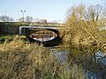
A6021 bridge where the River Rother joins the River Don at Rotherham
-
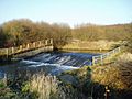
The weir at Beighton on the River Rother


Route Description
The planned Rother Link would start near the Chesterfield Canal at Killamarsh. It would then connect to Nethermoor Lake in the Rother Valley Country Park. From there, it would follow the River Rother.
The river passes under the M1 motorway bridge. It also goes by Catcliffe, where there's a railway bridge. Further along, you'd see the weir at Beighton. Finally, the Rother Link would reach Rotherham, where the River Rother joins the River Don.
