River Rother, West Sussex facts for kids
Quick facts for kids Rother |
|
|---|---|

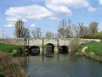
Fittleworth Bridge over the River Rother
|
|
| Country | England |
| Counties | West Sussex, Hampshire |
| District | Chichester |
| Towns | Petersfield, Midhurst |
| Physical characteristics | |
| Main source | Empshott, Hampshire |
| River mouth | River Arun Pulborough, West Sussex |
| Length | 52 km (32 mi) |
| Discharge (location 2) |
|
| Discharge (location 3) |
|
| Basin features | |
| Tributaries |
|
The River Rother is a river in England. It starts in Empshott, Hampshire, and flows into the River Arun at Stopham in West Sussex. The river is about 52 kilometres (32 mi) long. Most of it is in West Sussex, but the first 10 kilometres (6.2 mi) are in Hampshire.
The upper part of the river, from its start to Midhurst, was once used to power watermills. The earliest record of a mill here is from 1086, in the Domesday Book. No mills are working today, but many old mill buildings still stand. Some even have their original machinery. This part of the river also has very old bridges. They were built in the 1400s, 1500s, and 1600s.
The lower part of the river, from Midhurst to the River Arun, was used for boats. After improvements to the River Arun in 1615, boats could reach Fittleworth on the Rother. In 1790, the Arun Navigation was finished. Then, George Wyndham, 3rd Earl of Egremont, made the Rother navigable up to Midhurst. He built eight locks and some small cuts. This work finished in 1794. Many bridges from that time are still there.
However, when the railway came to Midhurst in 1859, fewer boats used the river. By the 1880s, commercial boats stopped using it completely. People still used the river for fun for many years. Stories of boat trips on the old navigation were published in 1914 and 1920. The navigation was officially closed in 1936. This happened after a university student pointed out it was still a public pathway.
The River Rother flows through the South Downs National Park. It is also a special place for wildlife, called a Site of Nature Conservation Importance. Many types of fish live here. The upper river is the only place in Sussex where you can find native white-clawed crayfish. The water quality is usually good. The river's flow is measured at four stations. Water from underground rock layers helps keep the river flowing in summer. This happens even though a lot of water is taken for public use.
Contents
River Rother: A Look at Its Past
After the River Arun was improved in 1615, boats could travel further upstream. This meant they could also use part of the River Rother, reaching as far as Fittleworth. In 1783, an engineer named William Jessop was asked to study the river. He came back in 1790 to survey it again.
In 1791, George Wyndham, 3rd Earl of Egremont, who lived at Petworth House, got a special law passed by Parliament. This law allowed him to improve the River Rother. He owned most of the land along the river. This meant he could choose the best way to improve the river. He could make the channel better or dig new cuts. The only rule was that he couldn't dig through gardens. The fees to use the river were low. The Earl wanted to help the area grow, not just make money.
The lower part of the river, below Midhurst, became navigable in 1794. This part was called the Western Rother Navigation. It was about 11.25 miles (18.11 km) long. Less than 2 miles (3.2 km) of this was new cuts. The rest followed the river's natural path. The river rose 54 feet (16 m) from Stopham to Midhurst. This was done using eight locks. It cost £13,300 to build.
Boats carried coal upstream. Downstream, they carried timber, corn, and special Petworth marble. A small branch canal, the Petworth Canal, connected the river to Petworth. It was 1.25 miles (2.0 km) long with two locks. It ended at Haslingbourne, south of the town. This branch opened in 1793 and cost £5,000. But it was only used for a few years. A new road made it easier to get to Petworth, so the canal was no longer needed.
Unlike many canals, the Earl hired local men to build the navigation. Most of them already worked for him. A clergyman praised him in 1808 for this. It caused less trouble and gave the workers more money. Their wages went up from 8 or 9 shillings (about 40-45p) a week to 14 or 15 shillings (about 70-75p). The Earl spent about £100,000 on waterways during his life. This included projects in Sussex and attempts to build a canal from London to Portsmouth. From 1802 to 1831, the canal made about £550 a year.
In 1859, a railway line opened from Horsham to Petworth. This caused traffic on the river to drop. By the 1880s, commercial boats stopped using the river. It was not officially closed until 1936.
Even after the navigation stopped being used for trade, people still enjoyed the river. A guide from 1895 said you could rent small boats (skiffs) in Midhurst and go fishing. A plumber named William Port rented out boats until 1912, when his boathouse burned down. You could also rent rowing boats at Coultershaw and Fittleworth.
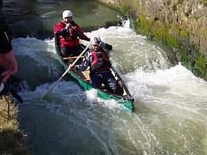
Another book from 1896, A New Oarsman's Guide, suggested canoeing from Iping to the River Arun. This was a 19 miles (31 km) trip, if there was enough water. By then, none of the locks worked. Boats had to be carried around them.
In 1887, part of the river bank near Todham Lock collapsed. This bank was next to the Cowdray estate. The owner of Cowdray, the Earl of Egmont, thought Lord Leconfield of Petworth should pay for repairs. After some discussion, they agreed to share the cost. They fixed the bank and added a floodgate at the top of the lock. Lord Leconfield thought his responsibility for the river ended when the Arun Navigation was officially closed in 1896.
However, in 1903, heavy rain and floods destroyed the floodgate and part of a nearby weir. This caused the river level to drop by 2 feet (0.6 m) through the Earl of Egmont's estate. The Earl sued Lord Leconfield for damages. The court agreed that the navigation was no longer useful. But the two men had to share the cost of rebuilding the floodgate. After that, the Earl would be responsible for its upkeep. He could also dredge (clean out) the river above the lock.
A book called My Holidays on Inland Waterways (1916) described a trip down the river in 1908. The author, P Bonthron, rented a boat from William Port in Midhurst. He and his friends reached Arundel on the River Arun in two days. The boat was then sent back to Midhurst by train. Another story of a similar trip in 1914 was in As the Water Flows (1920). This book described canoe trips on southern English rivers.
The river was finally officially closed because of a university student named Roger Sellman. He pointed out that the river was still legally a public pathway. This meant anyone could pay the fees and expect the owners to rebuild the locks. To avoid this, the estates at Petworth and Cowdray worked together to get the navigation officially declared unnecessary. Even though the River Arun Catchment Board and a canoe club objected, the closure was approved on April 15, 1936. However, in 2003, the Environment Agency said the river's navigation status was "unknown."
River Rother's Water and Wildlife
The River Rother flows through the South Downs, which is a beautiful area. Since 2011, it has been a national park. There are two large underground water stores, called aquifers, in the area. One is made of chalk, south of the river valley. The other is made of Lower Greensand and lies under the whole river. A layer of clay separates these two aquifers.
Water from these aquifers helps keep the river flowing during summer. This is called the base flow. Even so, there have been times when the river flow was very low, like during droughts in the early 1990s and in 1995/96. These low flows harmed the small creatures that live in the river, which are used to measure its health. But these creatures have since recovered. The Environment Agency monitors the river's water levels. They have observation points along the valley and measuring stations at Princes Marsh, Iping Mill, Halfway Bridge (on the River Lod), and Hardham.
The river's flow also increases from water released by several sewage treatment works. The three largest are at Princes Marsh, Petersfield, and Ambersham. They release between 0.22 and 1.10 million imperial gallons (1 and 5 Ml) of water per day. Three others at Rogate, Coultershaw, and Fittleworth release between 0.022 and 0.220 million imperial gallons (0.1 and 1 Ml) per day.
The entire River Rother, including some of its smaller streams, is a Site of Nature Conservation Importance. This means it's recognized as valuable for wildlife. The upper parts of the Rother are important for fish like brown trout, grayling, young sea trout, and salmon. You can also find bullhead, eel, lamprey, minnow, and stone loach. There have been worries about fewer fish. This is partly because soil washes into the river, leaving silt on the riverbed. Low river flows make this problem worse.
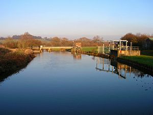
The lower parts of the river have similar fish. But in some areas, especially near weirs, you'll find bream, pike, and roach. The lowest parts of the river have chubb, dace, and perch. To help fish move along the river, especially those that swim upstream to lay eggs, special fish passes have been built around the measuring stations. The only known group of native white-clawed crayfish in Sussex lives in the upper parts of the Rother.
The water quality is generally good. This is helped by the very clean groundwater in the chalk aquifer. However, some small streams in the upper river are polluted by dirty water that isn't allowed to be released. Also, some areas have high levels of nitrates in the water, mostly from farm fertilizers. The Environment Agency has plans to fix these pollution problems from farms and towns.
The natural flow of the river is also affected by water being taken for public use. Water is taken from many places along the river. For example, in the upper parts, over 1.1 million imperial gallons (5 Ml) per day is taken from the aquifer. Another place takes over 2.2 million imperial gallons (10 Ml). Just before the river joins the River Arun, the Hardham Water Treatment Works takes over 2.2 million imperial gallons (10 Ml) per day from the river.
What's in a Name? The River Rother's Etymology
The river gets its name from Rotherbridge, not the other way around. Rotherbridge comes from the old Anglo-Saxon word Redrebruge. This means "cattle bridge." It was also the name of a Saxon administrative area called a Hundred. Before this, the river was known as the Scir.
Exploring the River Rother's Path
The River Rother's journey can be split into two main parts. The first part, from its source to Midhurst, had many mills but was never used by boats. The second part, from Midhurst to its mouth, was once navigable until the 1880s. This section had eight locks, some of which helped boats get around other water mills.
From Source to Midhurst: Mills and Old Bridges
The River Rother starts from several springs near Empshott in Hampshire. The main spring feeds watercress beds. It then flows under Mill Lane, south of the village. It continues east to Greatham Mill. The mill, its house, and a barn are very old, from the late 1700s or early 1800s. They are made of brick and are Grade II listed (meaning they are important historical buildings). All the mill's original machinery is still inside, but it doesn't work because the water has been moved.
The stream then turns southeast. It goes under the A3 West Liss bypass and Greatham Bridge. It is joined by other streams and turns south to Liss railway station. The railway and the river follow a similar path. The river goes under the railway five times before reaching Sheet. At the north of Sheet, the Ashford Stream joins the river, and there's another mill. After passing under the A272 road, it reaches Sheet Mill.
Tillmore Brook joins from the west, and the river turns east. At Durleighmarsh, it passes the ruins of Durford Abbey. This was an old monastery on the north bank. It is a scheduled ancient monument (a protected historical site). The site includes a barn with a water wheel. On the south bank is Durford Mill. The mill house is a grade II listed building, built in 1770. The mill itself has been updated and is not listed.
A bit further downstream, Harting Road crosses the river at Durford Bridge. This bridge was built in the early 1600s and has four rounded arches. It was repaired in 1924. North of Habin, North Lane crosses the river on Habin Bridge. This bridge has four rounded arches and was probably built in the 1600s or even earlier. It's made of stone and was repaired in the 1700s.
North of Dumpford, you'll find Terwick Mill. It's a grade II* listed building, meaning it's very important. It has two mills side by side and worked until 1966. The north mill is a timber-framed building from the 1500s. The south mill was built around 1750. It's now a house, but it still has two iron waterwheels and their machinery. The mill house is also a listed building.
The river turns north to pass east of Trotton. It's crossed by Trotton Bridge, from the early 1600s, which has five arched sections. The river then turns east again at Chithurst. Here, Abbey House, a timber-framed building from the 1400s, and the parish church, mostly from the 1000s, are on the north bank. An 18th-century stone and brick bridge with two arches carries Chithurst Lane over the river.

Continuing east, the river is crossed by Iping Bridge at Iping. This is a narrow stone bridge with five arches from the 1600s. West of the bridge is the site of Iping watermill. A mill was recorded here in the Domesday Book in 1086. By 1665, there were parts of a fulling mill (for cleaning cloth), a wheat mill, and a malt mill. It became a paper mill in the 1700s and worked until it burned down in 1930.
At Stedham, Stedham Lane crosses the river on a stone bridge with six arches. Five are from the 1600s, and one was added later. The river then makes a big loop north, where Stedham Mill used to be. The mill building is gone, but the mill house is a listed building. After the loop, Woolbeding Bridge, on the north edge of Midhurst, is from the 1400s or 1500s. It has four arches and was repaired in 1919. It's a grade II* listed building.
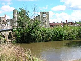
After another loop north, the river flows between Easebourne (northeast) and Midhurst (southwest). The bridge carrying the A272 road has two wide arches. It's hard to see now because a pedestrian bridge was added next to it. One of the arches was also widened in 1912. Below the bridge is the mill house and North Mill. The mill dates to 1840. The river then flows south, passing Cowdray on the east bank. Cowdray is an old fortified house, partly in ruins, and a protected historical site. It's in Cowdray Park, a beautiful landscaped park from the 1800s. On the opposite bank is a motte-and-bailey castle from the 1100s. Below this point, the river was once used by boats.
The end of the Rother Navigation was on a side stream at the south edge of Midhurst. There was a wharf (a place for boats to load/unload) and a basin (a small harbor). An old stone bridge crosses the navigation here. It was built in 1794 and repaired in 1977 to celebrate Queen Elizabeth II's Silver Jubilee.
The first lock was near Little Topham farm. A lock cut (a new channel) went across a loop in the river. Costers Brook joins the river below this lock site. The bridge at South Ambersham was built in 1791. It has a main arch over the navigation and a smaller arch to the north. Moorland Lock was on a straight cut across a large bend in the river.
Lodsbridge Lock also goes around a river bend that fed Lodsbridge Mill. The mill building is from the 1700s and is now a house. The mill house is also a listed building. A modern timber yard is north of the lock site. Lods Bridge, which carries a road over the river, was built when the navigation was made. The River Lod joins the Rother just below this bridge.
A wide spot in the modern river, near the old Midhurst railway line, marks Ladymead Lock. There was a weir (a small dam) to the south and the lock to the north. The fourth lock was Coultershaw Lock. The river here flows south. The mill stream ran east, and the lock was built west of the mill. Coultershaw Bridge now carries the A285 road over the mill stream. Near here is the Coultershaw Beam Pump. It was built in 1782 to bring water to Petworth House. The pump is powered by a water wheel. There were two corn mills and a malt mill here in 1534. The mill was updated in 1910 and destroyed by fire in 1923. A new building replaced it, but it was demolished in 1972. The beam pump, which was under the building, was saved and restored. It now supplies a fountain near the visitor center.
Shopham Lock was another lock cut across a large bend in the river. The bridge at the end of the lock is made of red and grey brick and has one rounded arch. It's from when the navigation was built and looks almost the same today. Nearby, the Petworth Canal went north to Haslingbourne Bridge. Below this cut, a stream from Burton Mill Pond joins the river. This pond supplied an iron forge built in 1789. Shopham Bridge, built in the 1800s, crosses the river here. It's made of red brick with stone details and has three arches.
At Lower Fittleworth, there's another mill building. It's not used and is in poor condition. It was built in 1628 and made bigger in 1742. It's on the grounds of the mill house, which was rebuilt in 1913. The lock cut ran along the southwest side of the mill. Fittleworth Bridge has a southern part built in the 1500s, rebuilt between 1717 and 1739, and changed for boats when the navigation was built. A northern part, next to the millpond, is from 1811-12.
Near where it joins the River Arun, the river makes a big loop south. A new channel was dug from the start of this loop to join the Arun. This channel had a lock. The loop fed Hardham Corn Mill. A lock bypassed the mill and its stream, allowing boats to reach the Hardham Tunnel cut. This tunnel branch was destroyed when a water treatment works was built. The modern weir near the river's mouth is much closer to the junction than the old lock was.
Protecting the River Rother
The Arun & Rother Rivers Trust (ARRT) was started in 2011. Its goal is to improve and protect the River Rother and other nearby waterways. It's a charity that also works on education, fish, wildlife, access, and pollution. The organization was asked in 2012 to create a plan for managing the river area. It worked with other groups to make sure local people's ideas were included in the plan.
How Healthy is the River Rother's Water?
The Environment Agency checks the water quality of rivers in England. Each river system gets an overall "ecological status." This can be high, good, moderate, poor, or bad. This status is based on things like the number and types of small creatures, plants, and fish. They also check the "chemical status," which compares chemical levels to safe limits. Chemical status is either good or fail.
Here's how the River Rother system's water quality was in 2019:
| Section | Ecological Status | Chemical Status | Overall Status | Length | Catchment |
|---|---|---|---|---|---|
| Western Rother (Upstream Petersfield) | Poor | Fail | Poor | 9.4 miles (15.1 km) | 21.91 square miles (56.7 km2) |
| Stanbridge Stream | Moderate | Fail | Moderate | 3.6 miles (5.8 km) | 9.44 square miles (24.4 km2) |
| Western Rother Durford | Moderate | Fail | Moderate | 3.0 miles (4.8 km) | 3.83 square miles (9.9 km2) |
| Harting Stream | Moderate | Fail | Moderate | 3.8 miles (6.1 km) | 4.43 square miles (11.5 km2) |
| Elsted Stream | Moderate | Fail | Moderate | 4.9 miles (7.9 km) | 5.16 square miles (13.4 km2) |
| Hammer Stream (W. Sussex) | Moderate | Fail | Moderate | 3.2 miles (5.1 km) | 9.36 square miles (24.2 km2) |
| Minsted Stream | Moderate | Fail | Moderate | 5.4 miles (8.7 km) | 7.01 square miles (18.2 km2) |
| Lod | Poor | Fail | Poor | 13.8 miles (22.2 km) | 20.58 square miles (53.3 km2) |
| Haslingbourne Stream | Moderate | Fail | Moderate | 5.5 miles (8.9 km) | 6.07 square miles (15.7 km2) |
| Western Rother | Moderate | Fail | Moderate | 34.8 miles (56.0 km) | 51.30 square miles (132.9 km2) |
The water quality is not always "good" for several reasons. These include sewage being released into the river, some changes made to the river channel, the presence of North American signal crayfish (which are an invasive species), and chemicals from farming and land management washing into the water.
Points of Interest Along the River Rother
| Point | Coordinates (Links to map resources) |
OS Grid Ref | Notes |
|---|---|---|---|
| Source of River Rother | 51°04′03″N 0°56′56″W / 51.0675°N 0.9490°W | SU737303 | |
| Greatham Mill | 51°04′04″N 0°54′34″W / 51.0679°N 0.9094°W | SU765304 | |
| River by Liss Station | 51°02′38″N 0°53′36″W / 51.0439°N 0.8934°W | SU776277 | |
| Sheet Mill | 51°00′42″N 0°55′03″W / 51.0118°N 0.9175°W | SU760241 | |
| Durford Mill | 51°00′13″N 0°53′24″W / 51.0036°N 0.8901°W | SU779232 | |
| Terwick Mill | 50°59′35″N 0°49′02″W / 50.9930°N 0.8173°W | SU831221 | |
| Stedham Mill | 51°00′06″N 0°46′13″W / 51.0017°N 0.7702°W | SU863232 | |
| Site of Midhurst Wharf | 50°59′05″N 0°44′05″W / 50.9847°N 0.7347°W | SU889213 | Upper end of navigation |
| Little Topham Lock | 50°58′49″N 0°42′30″W / 50.9802°N 0.7083°W | SU907208 | |
| Moorlands Lock | 50°58′58″N 0°41′15″W / 50.9827°N 0.6875°W | SU922211 | |
| Lodsbridge Lock | 50°58′59″N 0°40′18″W / 50.9830°N 0.6716°W | SU933212 | |
| Ladymead Lock | 50°58′23″N 0°39′01″W / 50.9731°N 0.6504°W | SU948201 | |
| Coultershaw Lock | 50°57′58″N 0°37′04″W / 50.9661°N 0.6177°W | SU971194 | |
| Shopham Lock | 50°57′38″N 0°36′07″W / 50.9605°N 0.6019°W | SU982188 | |
| Fittleworth Lock | 50°57′21″N 0°33′53″W / 50.9559°N 0.5648°W | TQ008183 | |
| Stopham Lock | 50°57′13″N 0°32′08″W / 50.9535°N 0.5356°W | TQ029181 | |
| Jn with River Arun | 50°57′09″N 0°31′43″W / 50.9524°N 0.5286°W | TQ034180 |
 | DeHart Hubbard |
 | Wilma Rudolph |
 | Jesse Owens |
 | Jackie Joyner-Kersee |
 | Major Taylor |


