
Petworth Canal facts for kids

The Petworth Canal was a waterway in England that didn't last very long. It opened in 1795 but was taken apart in 1826, only 31 years later! A powerful landowner, the Earl of Egremont, had his workers build this canal. It was about 1¼ miles long and connected to the Rother Navigation. The canal had two locks, which are like water elevators that raise or lower boats, each lifting boats by about 8 feet and 6 inches. The water for the canal came from the Haslingbourne Stream, which still flows in parts of the old canal bed today. The original idea was to make the canal much longer, connecting it all the way to the Wey Navigation near Shalford.
Contents
Building the Canal
Building the Petworth Canal started early in 1795. About twenty workers, called navvies, dug the canal. By August, the gates for the locks were being put in place, and a bridge was built at Haines Lock. The stone used for the bridges and locks came from nearby quarries in Fittleworth and Upperton. Special stones called coping stones, which are used on top of walls, were brought by barge from other locks near Midhurst. The canal was ready for boats by October 1795.
Big Plans for the Canal
The Earl of Egremont had a grand vision for the Petworth Canal. He wanted to create a safe water route that would link London, on the River Thames, with the south coast and the important naval base at Portsmouth. At that time, shipping goods by sea was risky because of dangerous places like the Goodwin Sands, where one of the Earl's own ships was wrecked. Also, during wars with France, there were military dangers at sea.
Why Extend the Canal?
The first plan was to extend the canal through the Shimmings Valley to Hamper's Green, which is on the north side of Petworth. From there, it would go north to join the Wey Navigation at Shalford. A famous canal engineer named William Jessop thought a route could be found through several towns like Northchapel, Shillinglee, Dunsfold, Alfold, and then following the Cranleigh stream to Bramley and Shalford. There was even a suggestion for a branch from Alfold to Horsham.
Farming and Finances
A writer interested in farming, Arthur Young, supported the canal idea. He believed it would help bring lime to farms, which would make the soil better and help crops grow. However, the Earl's surveyor, Thomas Upton, did a more detailed study in 1793. He found that the 32-mile route would have to climb about 220 feet to cross into Surrey. This would need many locks, with nine locks just to climb 58 feet to the north side of Petworth. Upton suggested that extending the Arun Navigation by 17 miles would be more practical. Even during the "Canal Mania" period, when many canals were being built, it became clear that extending the Petworth Canal would be too expensive and not worth the cost.
What Was Carried on the Canal?
The main goods transported on the Petworth Canal were chalk, coal, and timber.
- Coal: Coal from places like Newcastle or South Wales would arrive on large ships at Arundel. From there, it was moved onto smaller barges to be carried up the canal.
- Chalk: Chalk was brought up the River Arun from pits that the Earl owned near Houghton and Amberley.
- Timber: Wood and wood products, such as charcoal (used for fuel) and oak bark (used for tanning leather), were sent out from the Petworth area.
There was a lime kiln at Haslingbourne wharf, where lime was made and then sometimes sent down the canal by barge. However, most of the trade from Petworth went to Coultershaw wharf on the Rother Navigation. Even though Coultershaw was further from Petworth, it was on a well-maintained road to Chichester. Also, using the Petworth Canal didn't cost extra, but it meant barge masters had to go through two more locks. Sometimes, it was cheaper to transport goods by cart to and from the River Arun, which was free to use below Pallingham, avoiding the tolls on the Rother Navigation.
Why the Canal Closed
In 1824, the canal was cleaned out, and its banks were repaired. But in 1826, locks on the Rother Navigation needed urgent repairs. The Earl decided to close the Petworth Canal, which wasn't used very much, and reuse the materials from its locks. The locks were completely taken apart that summer. This decision didn't follow the legal rule that landowners had to keep the waterway working. After the canal closed, the section across the field below Haines Lock was filled in.
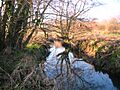
The Canal Today

Today, the old wharf at Haslingbourne has completely disappeared. An electricity sub-station and an old water treatment plant are now on the site, which is used for storing construction machines.
Below Haslingbourne Cottages, the Haslingbourne Stream still flows in the old canal bed. This part of the canal was cut through sandstone, creating a shaded, narrow gorge. This area is rich in mosses and lichens.
After leaving this cutting, at the site of the Upper Lock, the canal follows a straight path across low, wet ground. This area is now a fenced-off nature reserve. When you reach the site of Haines Lock, you can hear the stream flowing through a broken weir hidden in the plants. Here, the stream turns east into its natural path. The west bank of the canal runs into the pasture for about twenty meters, and you can just make out where the leveled canal used to be. Further on, where the Haslingbourne Stream gets close to the canal again, you can see the raised banks forming a straight line across the floodplain towards the river. A pond near the river marks the spot of an old weir and tumblebay.
Images for kids
-
The canal near Haines Cottages
-

The canal channel on the Rother floodplain
