River Lod, West Sussex facts for kids
Quick facts for kids River Lod |
|
|---|---|

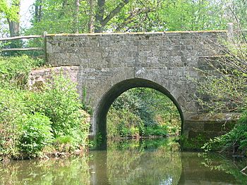
Bridge over the River Lod at Lords Wood Barns dated 1779
|
|
| Country | England |
| Physical characteristics | |
| Main source | Marley Heights Haslemere, Surrey 140 m (460 ft) |
| River mouth | River Rother Lods Bridge |
| Basin features | |
| Basin size | 52 km2 (20 sq mi) |
The River Lod is a small river in the north-west of Sussex, England. It helps drain an area of about 52 square kilometers (20 square miles). The river starts high up on Marley Heights, near Haslemere, about 140 meters (460 feet) above sea level.
From its source, the River Lod flows west past a place called Linchmere. Then it turns south towards Furnace Pond. This pond was once very important for making iron. The river then flows south-east, passing south of Fernhurst and through Lickfold and Lurgashall.
The river used to power Lurgashall Mill, which is now at the Weald and Downland Living Museum. After the mill, the river flows south between tall banks. It only overflows these banks after very heavy rain. Finally, it joins the River Rother at a spot called Lods Bridge.
Contents
How Iron Was Made Here
North Park Furnace: A Historical Ironworks
A long time ago, people made iron using a special furnace called a blast furnace. This furnace was located where Fernhurst and Linchmere meet. To power the large bellows that helped the furnace work, they needed water.
An artificial lake, covering about 2.5 hectares (6.2 acres), was built on the river. This lake held the water needed for the furnace. There was also a smaller pond about 400 meters (1,300 feet) north-west of the furnace. This extra pond held reserve water. Having a steady supply of water was very important for making iron without stopping.
The Old Mill and Its Story
Lurgashall Mill: Grinding Grain for Flour
Another artificial lake was created between Lurgashall and Lodsworth. This lake supplied water to power Lurgashall Mill. This mill was used to grind grain and make flour.
Today, you can visit the mill at the Weald and Downland Open Air Museum. It was moved there so people could still see how it worked in the past.
A Bridge with History
Lords Wood Barns: From Farm to Offices
On the east bank of the River Lod, near Lords Wood, are some old barns. These barns were once part of a place called Lodge Farm. In 1996, these old barns were changed into offices for a company. This project helped save the oldest barn from falling apart.
The bridge over the river here also needed repairs. One side of the bridge had sunk several centimeters. It was fixed and strengthened so it could support a new road built through the wood. The long-distance walking path called The Serpent Trail also crosses the river at this historic bridge.
Keeping the River Clean
Understanding Water Quality
The Environment Agency checks the water quality of rivers in England. They give each river system an overall "ecological status." This status can be high, good, moderate, poor, or bad. To figure this out, they look at several things.
They check the "biological status," which means they look at the types and numbers of tiny creatures like invertebrates (animals without backbones), flowering plants, and fish in the water. They also check the "chemical status." This means they measure how much of different chemicals are in the water and compare them to safe levels. Chemical status is either "good" or "fail."
River Lod's Water Quality in 2016
In 2016, the water quality of the River Lod was measured:
| Section | Ecological Status | Chemical Status | Overall Status | Length | Catchment |
|---|---|---|---|---|---|
| Lod | Poor | Good | Poor | 13.8 miles (22.2 km) | 20.58 square miles (53.3 km2) |
The main reasons why the River Lod's water quality was not "good" include sewage being released into the river. Also, nutrients from farms and land management practices can run off into the water. These things can make the water less healthy for plants and animals.
 | May Edward Chinn |
 | Rebecca Cole |
 | Alexa Canady |
 | Dorothy Lavinia Brown |

