Cranbrook, Kent facts for kids
Quick facts for kids Cranbrook |
|
|---|---|
 |
|
| Population | 6,717 (2011 census) |
| OS grid reference | TQ775365 |
| Civil parish |
|
| District |
|
| Shire county | |
| Region | |
| Country | England |
| Sovereign state | United Kingdom |
| Post town | CRANBROOK |
| Postcode district | TN17 |
| Dialling code | 01580 |
| Police | Kent |
| Fire | Kent |
| Ambulance | South East Coast |
| EU Parliament | South East England |
| UK Parliament |
|
Cranbrook is a historic town in the area of Cranbrook and Sissinghurst. It is located in the beautiful Weald of Kent, in South East England. The town sits about halfway between the larger towns of Maidstone and Hastings. It is also about 38 miles (61 km) southeast of central London.
Smaller villages like Sissinghurst, Swattenden, Colliers Green, and Hartley are part of the same local area. In 2011, about 6,717 people lived in the Cranbrook area.
Contents
- Discovering Cranbrook's Past
- How Cranbrook is Governed
- Cranbrook's Location and Landscape
- People Living in Cranbrook
- Cranbrook's Economy and Businesses
- Arts and Community Life
- Famous Landmarks
- Getting Around Cranbrook
- Schools and Learning
- Places of Worship
- Sports and Activities
- Famous People from Cranbrook
- Weather in Cranbrook
- See also
Discovering Cranbrook's Past
The name Cranbrook comes from old English words. Cran bric means "Crane Marsh." This suggests it was a marshy area where cranes, or more likely herons, used to gather. Over many years, the spelling changed from Cranebroca around 1100 to its current form, Cranbrook.
People have lived and worked here for a very long time. In Roman times, there was a big iron-making site near Little Farningham Farm. The Roman Fleet, called the Classis Brittanica, might have even helped manage this work.
Cranbrook became important for making cloth in the Middle Ages. King Edward III brought weavers from Flanders (now part of Belgium) to help. Cranbrook was perfect because it had fuller's earth, a special clay used to clean wool. It also had many streams to power mills that cleaned and thickened the cloth. Iron-making was also a big industry here, dating back to Roman times.
In 1290, Cranbrook was given permission to hold a market. This helped the town grow and become a busy trading place.
The Legend of Baker's Cross
There's a famous story about Baker's Cross, a spot on the edge of town. It's named after John Baker, who was an important official for Queen Mary I. Queen Mary was Catholic, and John Baker was known for being strict with Protestants.
The legend says that John Baker was riding to Cranbrook to have two local Protestants executed. But then, he heard news that Queen Mary had died. Some say he heard the church bells ringing, others say a messenger told him. He immediately turned back. The place where this happened is still called Baker's Cross today.
Even though the legend says he died there, John Baker actually died in his home in London.
After World War II, more houses were built around the old town center. Today, many of the old buildings in the town center are protected because they are historically important.
How Cranbrook is Governed
Since 1974, Cranbrook has been part of the Borough of Tunbridge Wells. This is the local council that helps run the area.
The local council for Cranbrook is called the Cranbrook and Sissinghurst Parish Council. It used to be just Cranbrook Parish Council, but it changed its name in 2009. The council offices are in the Old Fire Station on Stone Street.
Cranbrook's Location and Landscape
Cranbrook is located on the A229 road, which connects Maidstone to Hastings. It's about five miles north of Hawkhurst. Baker's Cross is on the eastern side of the town.
The area around Cranbrook has special geology. It's part of the Hastings Beds, which are layers of sand and clay. These layers are harder than the surrounding land, so they form the hills of the High Weald. This geology was important for Cranbrook's history. It provided iron ore for iron-making and fuller's earth for the cloth industry.
People Living in Cranbrook
In 2011, the census showed that 6,717 people lived in Cranbrook. A census is like a big count of everyone living in a country.
Cranbrook is sometimes called the smallest town in Kent. However, there is an even smaller place called Fordwich that also has a town council.
Cranbrook's Economy and Businesses
After the cloth industry became less important, farming became the main way people made a living in Cranbrook.
Banks started to open in Cranbrook in the early 1800s. The first one opened in 1803, but it closed quickly. Another bank, the Cranbrook Bank, opened in 1804.
A local family, the Tooth family, started a brewery at Baker's Cross. They even exported beer to Australia! Later, the brewery was sold and became known as Sharpe & Winch. This brewery was eventually bought by another company in 1927.
Arts and Community Life
In the 1800s, a group of artists called the "Cranbrook Colony" lived and worked here. They were known for painting everyday scenes of family life in rural Kent. They showed things like cooking, washing, and children playing.
The Queen's Hall Theatre is part of Cranbrook School. It hosts many different theatre groups, including the famous Cambridge Footlights. The Cranbrook Town Band, started in the 1920s, is a brass band that plays concerts in the Queen's Hall and St Dunstan's Church.
There have been many ideas to create a community center in Cranbrook. These plans aim to provide spaces for community groups, a day care center, and even public toilets. In 2016, the local council approved a plan to create new shops, homes, and a community center.
Famous Landmarks
Cranbrook has many old buildings, some dating back to the Middle Ages. At Wilsley Green, there's a very old house and cloth hall from the late 1300s. Many other medieval cloth halls can be found around the town, some now used as hotels or other businesses.
Glassenbury Park is an old manor house from the late 1400s. The Wilsley Hotel was built in 1864 as a home for the artist John Callcott Horsley. He was famous for designing the very first Christmas card! The town's war memorial was put up in 1920.
Windmills of Cranbrook
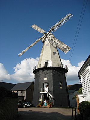
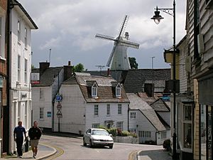
Cranbrook is famous for its windmills. Over the years, there have been four windmills in the area. Only one, the Union Mill, still stands today. It is a very tall and impressive building that can be seen from far away.
The Union Mill was built in 1814. It was run by the Russell family for 128 years. Today, it is owned by Kent County Council and is kept in working order. You can find it a short distance southeast of the church.
Other windmills in the area no longer exist. Cranbrook Common smock mill was taken down in 1902. Another smock mill on Windmill Hill is thought to have been moved to Sissinghurst around 1814.
Getting Around Cranbrook
The A262 and A229 roads pass near Cranbrook, connecting it to other towns. Local buses, run by Arriva Southern Counties, serve the town.
Cranbrook used to have its own train station, but it closed in 1961. The closest train station now is at Staplehurst.
Schools and Learning
Cranbrook has several schools for different age groups. Rainbow Pre-school helps younger children get ready for school. Cranbrook Church of England Primary School is for younger students. Colliers Green Primary School is also in the area. Dulwich Preparatory School is a private school that started during World War II.
Cranbrook School is a grammar school for older students (ages 13-18). It was founded way back in 1518! Many students at this school live there as boarders. The school has an observatory named after Piers Sellers, a former student who became a NASA astronaut. It has a powerful telescope used by a local astronomy club.
High Weald Academy used to be a comprehensive school, but it closed in 2022.
Places of Worship
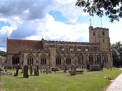
St Dunstan's Church is often called the "Cathedral of the Weald." Its tall tower, finished in 1425, has a wooden figure of Father Time. The church also has a clock that was a test version for the famous Big Ben clock in London.
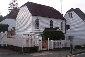
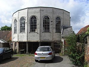
There are other churches in Cranbrook too. The Cranbrook Strict Baptist Chapel was built in 1787. Cranbrook Congregational Church, built in 1857, has a beautiful Neo-Gothic style. The Catholic St Theodore's Church opened in 1958.
Sports and Activities
Cranbrook has a long history with sports. In 1652, a court case in Cranbrook mentioned "a certain unlawful game called cricket." The court decided that cricket was actually allowed! Kent County Cricket Club even played some matches here in the 1850s and 1860s.
Cranbrook Juniors Football Club (CJFC) plays football matches on Saturday mornings. Cranbrook Rugby Club (CRFC) has teams for different age groups, from young children to adults.
The Weald Sports Centre offers many facilities. It has tennis courts, an indoor sports hall, a swimming pool, and a dance studio. If you like running, the Cranbrook joggers club explores routes around Angley Woods and Bedgebury Forest.
Famous People from Cranbrook
Many interesting people have connections to Cranbrook:
- Rev William Robert Fountains Addison (1883–1962), a brave soldier who received the Victoria Cross medal.
- Harry Hill, (1964–), a well-known comedian who went to school in Cranbrook.
- Piers Sellers, (1955–2016), the first British-born astronaut, who also studied in Cranbrook.
- Tim Smit, (1954–), the person who started the amazing Eden Project.
- Peter West, (1920–2003), a famous TV presenter and sports commentator.
Weather in Cranbrook
| Climate data for Cranbrook | |||||||||||||
|---|---|---|---|---|---|---|---|---|---|---|---|---|---|
| Month | Jan | Feb | Mar | Apr | May | Jun | Jul | Aug | Sep | Oct | Nov | Dec | Year |
| Mean daily maximum °C (°F) | 7 (44) |
7 (45) |
10 (50) |
13 (56) |
17 (62) |
21 (69) |
22 (71) |
22 (71) |
19 (66) |
14 (58) |
10 (50) |
7 (45) |
14 (57) |
| Mean daily minimum °C (°F) | 1 (33) |
1 (33) |
2 (35) |
4 (39) |
6 (43) |
9 (49) |
12 (53) |
11 (52) |
9 (49) |
6 (42) |
3 (38) |
2 (35) |
6 (42) |
| Average precipitation mm (inches) | 64 (2.5) |
48 (1.9) |
41 (1.6) |
53 (2.1) |
48 (1.9) |
41 (1.6) |
61 (2.4) |
58 (2.3) |
53 (2.1) |
71 (2.8) |
79 (3.1) |
66 (2.6) |
680 (26.9) |
| Source: Weatherbase | |||||||||||||
See also
 In Spanish: Cranbrook (Kent) para niños
 | William L. Dawson |
 | W. E. B. Du Bois |
 | Harry Belafonte |


