Ashdown Formation facts for kids
Quick facts for kids Ashdown FormationStratigraphic range: Late Berriasian to Valanginian |
|
|---|---|

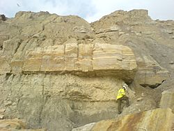
An exposure of the Ashdown Formation on the East Sussex coast.
|
|
| Type | Geological formation |
| Unit of | Wealden Group |
| Sub-units | Fairlight Clays |
| Underlies | Wadhurst Clay Formation |
| Overlies | Durlston Formation |
| Thickness | typically in the range 200-230 m |
| Lithology | |
| Primary | Siltstone, Sandstone |
| Other | Mudstone, Clay |
| Location | |
| Country | |
| Extent | Weald Basin |
| Type section | |
| Named for | Ashdown Forest |
The Ashdown Formation is a special layer of rock. It is part of a larger group of rocks called the Wealden Group. This rock layer is also the oldest part of the Hastings Beds. These rock groups form the main part of the Weald area. You can find them in the English counties of East Sussex and Kent.
Other rock layers in the Hastings Beds are the Wadhurst Clay Formation and the Tunbridge Wells Sand Formation. The Hastings Beds are part of an even bigger group called the Wealden Supergroup. This supergroup lies under much of South East England. The rocks of the Weald in East Sussex, including the Ashdown Formation, formed a long time ago. This was during the Early Cretaceous Period. This period lasted about 40 million years, from 140 to 100 million years ago. The Ashdown Formation itself formed about 140 million years ago. It gets its name from the Ashdown Forest in Sussex.
What the Ashdown Formation is Made Of
The Ashdown Formation is mostly made of three types of rock. These are sandstones, siltstones, and mudstones. In the eastern part of the area, the lowest parts of the formation have more clay. As you go higher up, the top 30 to 50 meters become sandier. The clays often have cool purple and brick-red colors.
In the past, people sometimes called these different parts 'Fairlight Clays' and 'Ashdown Sands'. But now, scientists see it as one big formation. This is because the clay layers don't stretch across the whole Weald area. Even so, maps from the British Geological Survey often show where the clays and sands are. The whole formation is usually between 180 and 215 meters thick.
The bottom of the Ashdown Formation sits on top of another rock layer. This layer is called the Greys Limestones Member of the Purbeck Beds. However, you can't see this boundary anywhere in the Weald today. The top of the Ashdown Formation is a thick sandstone layer. It's known as the Top Ashdown Sandstone. Above this is a very coarse sandstone called the Top Ashdown Pebble Bed. This pebble bed is part of the Wadhurst Clay Formation. The Top Ashdown Sandstone is a very important marker. It helps geologists identify rock layers across the region. It is usually between 1.2 and 8 meters thick. Other important marker beds in the formation include the Cliff End Sandstone and the Lee Ness Sandstone.
Where to See the Ashdown Formation
You can see the Ashdown Formation best along the cliffs. These cliffs stretch for about 8 kilometers between Hastings and Pett Level. Part of this area is a special place called a Site of Special Scientific Interest. This means it's protected because of its important geology. It can be tricky to get to these cliffs safely. This is because of the tides in the English Channel and the cliffs being unstable.
In this area, you can follow the rock layers from Lee Ness Ledge. You can see the different marker beds clearly. You can also see where the Ashdown Formation meets the Wadhurst Clay. This happens near Hastings Castle to the west and Cliff End to the east. The clay parts, which used to be called 'Fairlight Clays', look different from the sandy parts. The sandy parts, or 'Ashdown Sands', have clear layers of sandstone and siltstone.
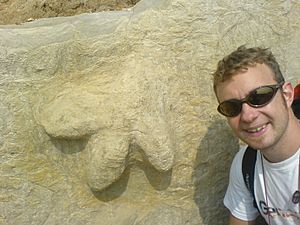
Lee Ness Ledge is famous for its Lee Ness Sandstone. It's also known for many well-preserved fossilized dinosaur footprints. You can often find footprints from the Iguanodon dinosaur there!
Why the Cliffs Fall Down

The coast between Hastings and Pett Level has had many landslides. These have happened recently and in the past, going back to the 1700s. You can see them in places like Covehurst Wood and the Fairlight, Ecclesbourne, and Warren Glens. These landslides happen for a few reasons. One reason is the different types of rock in the Ashdown Beds. Another reason is how waves hit the bottom of the cliffs.
When the tide is high, waves crash into the soft, clay-rich parts of the cliffs. This wears away the bottom of the cliffs. Then, the sandstones and siltstones above lose their support and fall down. This can cause big rock falls. If sandstones are mixed with silts and clays, it can lead to different types of landslides. These include rotational landslides, block slides, and mud flows.
Normally, the fallen rocks and dirt should protect the bottom of the cliff from more waves. But these rocks and sediments get moved along the beach by ocean currents. This leaves the cliffs open to the waves again. So, they are still likely to have more landslides.
|
 | Misty Copeland |
 | Raven Wilkinson |
 | Debra Austin |
 | Aesha Ash |


