
Yorkshire Wolds facts for kids
Quick facts for kids Yorkshire Wolds |
|
|---|---|

A winter view across the Yorkshire Wolds
|
|

Location in Northern England
|
|
| Location | Northern England |
| Coordinates | 54°00′22″N 0°26′24″W / 54.006°N 0.440°W |
The Yorkshire Wolds are a range of low hills in the north-eastern part of England. They are found in the areas known as the East Riding of Yorkshire and North Yorkshire. The name "Wolds" also refers to the whole area where these hills are located.
On their western side, the Wolds rise up to a steep slope called an escarpment. This slope then drops sharply down to a flat area known as the Vale of York. The highest point on this escarpment is Bishop Wilton Wold, which is 246 meters (807 feet) above sea level. To the north, across the Vale of Pickering, you can see the North York Moors. To the east, the hills become flat and turn into the plain of Holderness.
The biggest town in the Wolds is Driffield. Other important places include Pocklington, Thixendale, and Kilham. Kilham was once the main "capital" of the Wolds. The highest village in the Yorkshire Wolds is Fridaythorpe, sitting at 168 meters (550 feet) above sea level.
Contents
What are the Yorkshire Wolds Made Of?
The hills of the Yorkshire Wolds are made from a type of rock called limestone. This limestone formed a long, long time ago, during the Cretaceous period, when this area was covered by a warm, shallow sea. The chalk is part of what scientists call the Chalk Group.
This chalk rock forms a curved shape that runs from the River Humber estuary (near Kingston upon Hull) northwards past Market Weighton to the Malton area. From there, it turns east towards the North Sea. When it reaches the coast, the chalk forms impressive cliffs. Some of the most famous cliffs are at Speeton Cliffs, Bempton Cliffs, and Flamborough Head. The area around Flamborough Head is even a special protected place called a Heritage Coast.
South of the Humber River, the same chalk rocks continue into the Lincolnshire Wolds. The chalk layers are like a giant cake, with different types of chalk stacked on top of each other. The older, harder chalk forms the lower parts of the hills, while the younger chalk forms the higher parts and the flat areas on top.
The Wolds are also special because they were not covered by ice during the last ice age. This means they don't have the thick layers of till (rock and dirt left by glaciers) that you find in other nearby areas.
Nature and Landscape
Most of the Yorkshire Wolds is a high, gently rolling area. It has many deep, steep-sided valleys with flat bottoms. These valleys were carved out by glaciers long ago. The chalk rock in the hills lets water drain away very well. This means that most of these valleys are dry, and it's hard to find surface water anywhere in the Wolds.
When you look at the Wolds from above, the valleys are often hidden. This makes the landscape seem much flatter than it actually is. Because of this unusual shape, farming here is a bit "upside-down." Farmers often keep animals like sheep and cows grazing in the valleys, while they grow crops on the flatter hilltops.
Weather in the Wolds
The Yorkshire Wolds are in the northern part of England. This means they have a mild, wet climate, which is typical for places near the sea. The weather can change quickly from day to day. The Gulf Stream, a warm ocean current, helps keep the region mild for its location.
Because the Wolds are higher than the land around them, they are a little cooler. In winter, snow can drift and cause problems. On average, the Wolds get about 729 millimeters (28.7 inches) of rain each year, with rain falling on about 128 days. January is usually the coldest month, and December is the wettest. August is the warmest month, and February is the driest.


Places to Explore
Northern Wolds and Flamborough Head

The Wolds meet the sea at Flamborough Head. Here, the chalk cliffs drop over 400 feet (130 meters) straight down into the North Sea. South of Flamborough is the seaside town of Bridlington. To the north, the tall cliffs at Speeton look out over Filey Bay. Further inland, the high Wolds slope overlooks the Vale of Pickering.
A small stream called the Gypsey Race flows through this area in a valley known as the Great Wold Valley. This stream empties into Bridlington Harbour. Sometimes, in dry weather, parts of the Gypsey Race disappear underground and then reappear further downstream.
Another interesting feature here is Danes Dyke. This is a huge ditch with two raised banks that stretches across Flamborough Head. It's about 18 meters (20 yards) wide and 6 meters (20 feet) deep. Its exact purpose is a mystery, but it's definitely not Danish!
Bempton Cliffs is a very important place for seabirds. It's a nature reserve run by the RSPB (Royal Society for the Protection of Birds).
Apr2006.jpg)
Some villages to note include Flamborough village, and North Landing and South Landing on Flamborough Headland. The village of Reighton has many buildings made from the local chalk. Hunmanby was once a big market town.
Many villages are found at the bottom of the northern Wolds slope. Each village parish includes some chalk hillside, fertile land, and marshy areas in the Vale of Pickering. Fordon is one of England's smallest villages. Rudston is home to Britain's tallest standing stone, which you can see in the churchyard.
Driffield Area
On the eastern side of the Wolds, there are many villages stretching from Bridlington to Driffield. These villages are often located where springs come out of the ground, marking the natural edge between the chalk Wolds and the clay area of Holderness. Driffield is in the middle of the Wolds and is an important market town. It's often called the "Capital of the Wolds."

Interesting villages include Nafferton, which has a pretty mill pond fed by springs. Near Ruston Parva is Danes Graves, an archaeological site with about 500 small round burial mounds from the Iron Age. Burton Agnes has the ruins of a manor house from 1170 AD and a beautiful Elizabethan Hall. Kilham was a busy market town in the Middle Ages. The area around Kilham has a long history, with an Iron Age cemetery, a Roman road (now called Woldgate), and an Anglo-Saxon cemetery all close by. Sledmere village is an "estate" village, meaning it was built around Sledmere House, which has been home to the Sykes family since the 1700s.
Southern Wolds

In the south, the Wolds are at their narrowest. They are located between the flat land of Holderness to the east and the Vale of York to the west. The Humber River cuts through the chalk, separating the Yorkshire Wolds from the Lincolnshire Wolds to the south. In Roman times, people crossed the Humber here by walking or riding through the water. Today, the Humber Bridge crosses the estuary.
This area has excellent farmland and many pretty villages. Some notable ones are Walkington with its village pond, and Bishop Burton with its whitewashed cottages and large pond. Skidby has a working windmill from 1821, which is now a museum about farming. North Newbald is in a narrow valley and has a famous Norman church.
Central Wolds
The western slope of the Wolds reaches its highest point at Garrowby Hill. This area has many attractive wooded valleys, with small streams flowing down to the Vale of York. The market towns of Pocklington and Market Weighton are located between the Wolds and the vale.
Large parks and grand houses can be found along the slope, such as Garrowby Hall and Londesborough Hall. The village of Millington is in a beautiful spot within Millington Dale. The road along the top of the dale offers amazing views. The village of Kiplingcotes is famous for the annual Kiplingcotes Derby horse race, which is said to be the oldest horse race in England.
Western Wolds

From Garrowby Hill northwards to Ganton, the high slope of the Wolds curves around. It looks out over the Vales of York and Pickering. Villages in this area are often found at the bottom of the slope or in the upper part of the Great Wold Valley. Rillington is a nice village with a stream and a nearby park at Scampston. At Knapton village, there's a hall and park. Above the village, in Knapton Plantation, is Staple Howe, an Iron Age site.
The twin villages of East and West Heslerton are further along the A64 road. West Heslerton is a well-known archaeological site, where many ancient objects from different time periods have been found. Wharram Percy is one of the most famous deserted medieval village sites in the UK.
History and Ancient Discoveries
The Yorkshire Wolds are full of amazing archaeological finds. There are many sites from the Neolithic (New Stone Age), Bronze Age, and Roman-British periods all across the area.
The fertile chalk soils, good grazing land, light tree cover, and stone for making tools made this area very appealing to early settlers during the Neolithic period. Along with other important places like Wessex and Orkney, the Yorkshire Wolds is a key area for understanding how the Neolithic period developed in Britain. It became a major place for people to live during this time.
Most people lived in isolated farms rather than large settlements. However, we have found more evidence of burial sites and special monuments. Recently, long burial mounds (called long barrows) at Fordon and Kilham have been dated to around 3700 BC. A famous round burial mound from this time is the huge Duggleby Howe. A henge monument (a circular earthwork) from the Neolithic period has been found at Maidens Grave Rudston. The Rudston Monolith is also thought to be from this time. There's also a large group of Neolithic ritual sites near the eastern end of the Great Wold Valley.
More than 1,400 Bronze Age round burial mounds have been found in the Yorkshire Wolds. These mounds usually contain one or more burials, along with items that were buried with the person. They can be found alone or, more often, grouped together to form cemeteries. Even though many of these sites have been flattened by farming over time, they are still visible today.
The Romans arrived in this area around 71 AD. They built a road network from their base at Brough on the Humber River. One road went towards York, and another went to Malton. Both of these roads crossed the Wolds. At first, the local people (called the Parisi) were not much bothered by the Romans. But over time, they started to adopt Roman ways of life and use Roman goods. There are Roman villa sites (large country houses) in the Wolds at Rudston, Harpham, and Wharram-le-Street.
Walkington Wold, near the village of Walkington in the southern Wolds, is the site of an Anglo-Saxon execution cemetery. This is the only known example of such a site in northern England.
Culture and Art
The writer Winifred Holtby, who was born in Rudston, lived in the Wolds area. She described the Wolds as "fold upon fold of the encircling hills, piled rich and golden."
The Yorkshire Wolds Versatile Brass is a music group that performs for local communities in the region.
The famous artist David Hockney has featured the Yorkshire Wolds in many of his paintings. These paintings were shown in a big exhibition called 'A Bigger Picture' in 2012.
A two-part BBC television show called Yorkshire Wolds Way was first shown in January 2017. It followed a journey along the Yorkshire Wolds Way walking path.
The Wolds Way Walking Path
The Yorkshire Wolds Way is one of England's nine National Trails. It is a long-distance footpath that goes all the way along the Wolds. It starts at the Humber Bridge in Hessle and ends at Filey on the coast. This path is managed by an organization called Natural England.
Images for kids
-
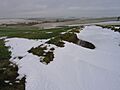
A winter view across the Yorkshire Wolds
-
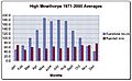
Sunshine and rainfall recordings made at High Mowthorpe on the western scarp of the Wolds
-
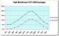
Temperature recordings made at High Mowthorpe on the western scarp of the Wolds
-
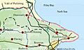
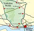
Map of the northern area of the Yorkshire Wolds
-
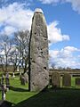
The Rudston Monolith, Britain's tallest standing stone.
-
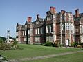
Burton Agnes Hall
-
The southern area of the Yorkshire Wolds
-
Wharram Percy deserted medieval village
See also
 In Spanish: Wolds de Yorkshire para niños
