Great Wold Valley facts for kids
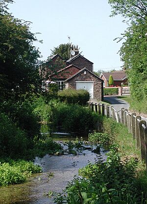
The Great Wold Valley is a wide valley in the Yorkshire Wolds in northern England. It's home to the Gypsey Race, a special stream that doesn't always flow. This stream starts near Wharram-le-Street and flows east. It travels through the northern Yorkshire Wolds. Finally, it reaches the sea at Bridlington.
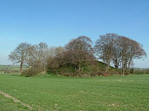
Long ago, during the Neolithic period (the New Stone Age), people thought the Great Wold Valley was a very important place. They used it for worship. You can still find many ancient sites here. The Gypsey Race stream takes two sharp turns. It goes south at Burton Fleming and then east again at Rudston. This stream is quite mysterious. It can flood even when it hasn't rained much. This happens because of how water moves underground. People in ancient times might have thought this was magical. This could be why so many important Stone Age sites are found along its path. These include the Rudston Monolith and old burial mounds. Some famous mounds are Willy Howe, Duggleby Howe, and Wold Newton. The word "Howe" means a small hill or a man-made mound.
The Valley's Natural Features
The ground beneath the valley is made of chalk. This chalk formed a very long time ago. It was created during the Cretaceous period. This was the time when dinosaurs roamed the Earth. On the valley sides, you'll find layers of wind-blown sand. In the valley bottom, there's a mix of soil and broken chalk. This material washed down from the hills during the Ice Age.
Before the Ice Age, the Great Wold Valley was where the River Ure flowed into the sea. But huge ice sheets blocked the river's path. This changed the River Ure's course forever.
How People Shaped the Valley
The Great Wold Valley holds many clues about ancient people. It shows how they lived and used the land. As mentioned, it was a key place for worship in prehistoric times. Many important ancient sites are protected here. Rudston village was a major center for prehistoric activity. Four ancient pathways, called cursus, meet near the village.
The Argham Dyke is an old earthwork. It dates back to the Bronze Age. It crosses the area near Rudston. We also know that people lived here during the Iron Age and Roman times. Aerial photos show old fields, tracks, and farms. A Roman villa has also been found south-west of Rudston.
Today's fields look different. They were created in the 1700s and 1800s. This was when large areas of shared land were divided up. Farmers moved out of villages to live on their own farms. These farms were often built on high ground. Trees were planted around them to protect them from the wind. Near Bridlington, you can find places for fun and tourism. These include camping sites, hotels, and fishing lakes.
Wildlife and Nature
Streams that flow only sometimes are called 'gypsey springs'. You can find them all over the Yorkshire Wolds. The Gypsey Race in the Great Wold Valley is the most famous one. It's a chalk stream. This means it flows over chalk bedrock. It's home to many plants like bur-reed.
West of Boynton, there's a special area called Boynton Willow Garth SSSI. It's a mix of different natural places. You'll find wet marshy land, bushes, woodland, and flowing water. In the more open parts of the valley, you can see plants like meadowsweet. Under the trees in the woodland, you might spot wood avens.
The Gypsey Race starts in the upper valley near Duggleby Howe. This part of the valley is wide and flat. The valley floor is about 50 meters above sea level. The sides rise to 150 meters. Sometimes, the stream disappears underground. Most of the land here is used for farming crops. Some areas are grasslands. Hedges separate the fields. They also act as pathways for wildlife.
 | Sharif Bey |
 | Hale Woodruff |
 | Richmond Barthé |
 | Purvis Young |


