Lincolnshire Wolds facts for kids
Quick facts for kids Lincolnshire Wolds |
|
|---|---|
 
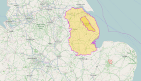
The Lincolnshire Wolds (top), location within Lincolnshire (bottom)
|
|
| Location | Lincolnshire, England |
| Area | 560 km2 (220 sq mi) |
| Established | 1973 |
| Governing body | Lincolnshire Wolds Countryside Service |
The Lincolnshire Wolds are a beautiful area of low hills in the county of Lincolnshire, England. They stretch alongside the North Sea coast, from the Humber Estuary in the north-west down to the Lincolnshire Fens in the south-east. This special place is known as an Area of Outstanding Natural Beauty (AONB). It is the highest land in eastern England between Yorkshire and Kent.
Contents
What are the Lincolnshire Wolds Made Of?
The Wolds are mostly made of a type of rock called limestone. This limestone formed from tiny sea creatures during the Cretaceous period, which was a very long time ago. This rock is part of what is called the Chalk Group.
Underneath the chalk are other layers of sedimentary rock. These layers formed from sand, mud, and other materials settling at the bottom of ancient seas. All these rock layers gently slope towards the east. They create a steep slope, or 'scarp', that runs from Barton-upon-Humber south-east towards Spilsby.
The chalk layers you see include:
- White Chalk Subgroup
- Burnham Chalk formation
- Welton Chalk Formation
- Grey Chalk Subgroup
- Ferriby Chalk Formation
- Hunstanton Chalk Formation
The lower parts of the Wolds' steep western side are made of the thinner Hunstanton and Ferriby Chalk. The Welton Chalk forms most of the gentler eastern slopes. In some areas, especially in the north, you can also find Kimmeridge Clay Formation at the bottom of the scarp. Further south, other rock layers appear, like the green-brown Carstone Formation.
Many dry valleys cut into the Wolds. These valleys were formed during past ice ages. Water flowing over frozen ground carved out the western valleys. Some eastern valleys were created by water flowing under glaciers. During the last ice age, ice did not cover the Wolds themselves. However, an earlier ice age left behind layers of clay, silt, sand, and gravel in the central and southern parts. Some parts of the Wolds, like at Saxby All Saints, have also had landslides.
Exploring the Geography of the Wolds
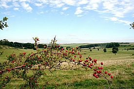
The Lincolnshire Wolds are known for their low hills and unique dry, open valleys.
The Lincolnshire Wolds can be divided into four main parts:
- the main area of chalk hills in the north
- the north-west scarp (a steep slope)
- an area of ridges and valleys in the south-west
- the clay lands in the south-east
Near the village of Goulceby, you can find the Red Hill nature reserve. It's special because its soil and the chalk underneath are an unusual red colour.
The highest point in all of Lincolnshire is called Wolds Top. It's located just north of Normanby le Wold and is about 168 metres (551 feet) above sea level. You can find a special marker there called a trig point.
Other notable hills in the Wolds include:
- Castcliffe Hill - 139 metres (456 feet)
- Gaumer Hill - 129 metres (423 feet)
- Meagram Top - 58 metres (190 feet)
- Warden Hill - 113 metres (371 feet)
- Tetford Hill - 142 metres (466 feet)
- Hoe Hill - 127 metres (417 feet)
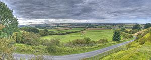
From the Wolds, you can enjoy amazing views across the flat fens and salt marshes of Lindsey and Holland. On a clear day, you might see many famous structures. These include the Belmont mast, Boston Stump, Grimsby Dock Tower, the Humber Bridge, Lincoln Cathedral, and St James' Church in Louth. You might also spot the radar station near Normanby, Tattershall Castle, and the wind turbines on the coast near Mablethorpe.
Rivers and Waterways
Several rivers flow through or start in the Lincolnshire Wolds. Here are some of them:
| Name | Source | Source Elevation (m) | Mouth | Mouth Elevation (m) | Notes |
|---|---|---|---|---|---|
| River Bain | Ludford | 130 | River Witham, Dogdyke | 2 | |
| Great Eau | North Sea, Saltfleet Haven | ||||
| River Lud | North Sea, North Coates | Also known as the Louth Navigation because it was made into a canal. | |||
| River Lymn | Belchford | 91 | North Sea, Gibraltar Point | 0 | |
| River Rase | Tealby | 118 | River Ancholme, Bishopbridge | 6 | |
| River Waring | Belchford | 100 | River Bain, Horncastle | 28 |
A Special Protected Area: Area of Outstanding Natural Beauty
The Lincolnshire Wolds were officially named an Area of Outstanding Natural Beauty (AONB) in 1973. This means the area has special protection to keep its natural beauty safe. The Lincolnshire Wolds Countryside Service helps manage and look after this area.
The Wolds AONB covers about 560 square kilometres. The Countryside Service also looks after a wider area called the Lincolnshire Wolds Character/Natural Area. This larger area includes the AONB and other nearby parts of the Wolds.
The AONB crosses the borders of several local councils. These include Lincolnshire County Council, East Lindsey District Council, West Lindsey District Council, and North East Lincolnshire Council. Signs with hills and trees mark the boundaries of the AONB on roads leading into the area.
People and Places in the Wolds
The Wolds are not very crowded and have a quiet, rural feel. Several small market towns are located around the edges of the Wolds:
- Alford
- Horncastle is often called the "gateway to the Wolds" on tourist signs. It's just outside the southern part of the AONB.
- Louth is known as "the capital of the Wolds."
- Market Rasen
- Caistor
- Spilsby
Many place names in the Wolds show a strong Viking influence from the area's history. You can also find many 'lost villages' from the Middle Ages. These were settlements that people left because of changes in how land was used, poor soil, or diseases.
Several important roads and paths cross the Wolds. Caistor High Street follows an old Roman road and is now the B1225. It runs from Caistor to Baumber. The ancient Bluestone Heath Road is an old path that crosses the Wolds from west to east. Several main "A" roads also go through the AONB.
Today, the Wolds are a popular place for tourists to visit. The area is connected to the famous poet Tennyson, who was born in Somersby. Farmers are also encouraged to offer tourist activities. The roads of the Wolds are very popular with motorcyclists. The area is also home to Cadwell Park, one of the UK's top race circuits.
The Wolds are also great for walkers. The Viking Way is a long-distance footpath that starts in Barton-upon-Humber. It crosses the Lincolnshire Wolds and continues into Rutland. There is also a youth hostel in the middle of the Wolds at Woody's Top, near the village of Tetford.
 | Georgia Louise Harris Brown |
 | Julian Abele |
 | Norma Merrick Sklarek |
 | William Sidney Pittman |


