
River Witham facts for kids
Quick facts for kids River Witham |
|
|---|---|

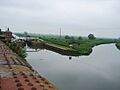
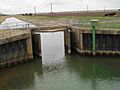
The Grand Sluice at Boston, where the River Witham flows into The Haven.
|
|

Path of the River Witham [1]
|
|
| Country | United Kingdom |
| Country within the UK | England |
| Counties | Lincolnshire, Leicestershire |
| Cities | Lincoln |
| Towns | Grantham, Boston |
| Physical characteristics | |
| Main source | South Witham, Lincolnshire 130 m (430 ft) 52°45′20″N 0°41′27″W / 52.755622°N 0.690858°W |
| River mouth | The Haven, Boston, Lincolnshire 0 m (0 ft) 52°57′52″N 0°00′36″W / 52.964541°N 0.010042°W |
| Length | 132 km (82 mi) |
| Discharge (location 2) |
|
| Basin features | |
| Basin size | 3,817 km2 (1,474 sq mi) |
| Tributaries |
|
| Progression : River Witham — The Haven — North Sea | |
The River Witham is a river mostly found in Lincolnshire, England. It starts near South Witham and flows through Grantham and Lincoln. Finally, it reaches Boston and empties into The Haven, which is a tidal part of The Wash. The name "Witham" is very old and its meaning is not fully known.
People have used the River Witham for travel and transport since the Iron Age. In Roman times, it was important for moving goods. A canal called the Fossdyke was built to connect the Witham to the River Trent. This helped Lincoln become a major Roman city. After a big flood in 1014, the river's mouth moved, and Boston grew into an important port.
Over the years, people built sluices (water gates) to stop the sea from flooding the land. The biggest one, the Great Sluice, was built in 1766. It helped keep the river level steady above Boston. Many drains connect to the Witham, with special doors that close if the river gets too high. Today, boats can travel on the river from Lincoln to Boston. There are locks at Lincoln, Bardney, and the Grand Sluice.
Contents
The River's Journey


The River Witham starts high up near South Witham, about 130 meters (340 feet) above sea level. It flows north, passing under the A1 road. This road often follows the river's path. Near Great Ponton, the Cringle Brook joins the Witham. The river then flows through Grantham, where it is already much lower, at about 52 meters (170 feet) above sea level.
After Grantham, the river turns west through Marston. It then flows north again, passing Claypole. For about 3 miles, it forms the border between Lincolnshire and Nottinghamshire. The River Brant joins it before the Witham reaches Lincoln, where it is only about 5 meters (16 feet) above sea level.
The upper parts of the river are important for farming and for wildlife. You can find fish like roach and pike, small animals like water voles, and native crayfish here.
In Lincoln, the river flows into a lake called Brayford Pool. It then goes under the old High Bridge. This bridge is quite small, which can make it hard for boats to pass. It also limits how much water can flow through during floods. To help with floods, there's a channel called the Sincil Dyke. This channel helps divert water around the city center.
From Lincoln, the river turns east, then south, cutting through an area of higher ground called the Lincoln Gap.
A long walking and cycling path, called the Water Rail Way, follows the river from Lincoln to Boston. This path uses old railway tracks and river paths. It's part of National Cycle Route 1 and has cool sculptures by local artists along the way. These sculptures show animals like Lincoln longwool sheep and Lincoln Red cows.
River History
.jpg)
The name "Witham" is very old, even older than Anglo-Saxon or Roman times. Its exact meaning is a mystery. Some think it means "river plain." In ancient times, it was called the Grant Avon, meaning "divine stream."
People have used the river for travel since the Iron Age. Amazing old items have been found in the river, like the Witham Shield (an Iron Age shield) and the Fiskerton Boat (an old log boat). These are now in museums.
The Witham was very important for the Romans. Lincoln (Lindum) was a key Roman city. To help move goods, the Romans built the Fossdyke canal to connect the Witham to the River Trent. This gave Lincoln a way to reach the east coast and other major rivers.
Over time, the river's path changed. In 1014, a huge flood caused the Witham to flow into The Haven at Boston. This helped Boston grow into a busy port in the 12th and 13th centuries, trading wool and salt.
The river sometimes got blocked with silt, making it hard for boats to pass. So, people started building sluices and barriers from 1142 onwards. In 1743, engineers surveyed the river to plan improvements. They suggested a new, straighter channel to avoid the river's winding path above Boston.
Making the River Easier to Use
In the 1760s, a big project began to improve the river. Engineers like John Grundy Jr. and John Smeaton helped plan it. They decided to build a "Grand Sluice" and a new, straighter channel. Work started in 1763, and the Grand Sluice was finished in 1766. It cost a lot of money, but it helped control water levels and prevent floods.
The Grand Sluice was a huge structure. It kept the water level high above Boston and had big flood gates. This project also led to the creation of the Witham Navigable Drains, a network of channels that helped turn marshy land into farmland. Today, these channels are managed by special boards to prevent flooding.
Later, in 1791, engineers looked at improving the river again, especially around Lincoln's old High Bridge. This bridge was very narrow and shallow. They decided to lower the riverbed under the bridge to make it easier for boats to pass.
The Grand Sluice Today
When it was finished in 1766, the Grand Sluice had three wide channels and a lock for boats. The lock was made bigger in 1881. Today, the old gates have been replaced with modern steel gates.
River Improvements and Railways
By 1802, the river needed more work. New locks were built at Stamp End and Bardney. A new channel was also dug near Fiskerton. At this time, boats were mostly sailing vessels or barges pulled by horses.
In 1816, the first steam packet boat, named Witham, started operating on the river. These steam boats soon became very popular.
When railways arrived in Lincoln in 1848, they changed everything. The Great Northern Railway (GNR) took over the river navigation. The railway line from Lincoln to Boston ran right next to the river. The railway company made train travel very cheap to attract passengers away from the river boats. By 1863, the steam packet boats had stopped running. Freight traffic on the river also dropped a lot.
Even though river traffic decreased, the railway company still had to maintain the river. Today, the river is managed by the Canal & River Trust.
Boating on the Witham Today
Today, the River Witham is mainly used by pleasure boats. Commercial boats mostly stop at the port of Boston. Boats can pass through the Grand Sluice lock, but only at certain times when the tide is right. This is because the sea level changes a lot.
The Witham is navigable from Brayford Wharf in Lincoln to Boston. There are two locks between Boston and Lincoln: one at Bardney and the Stamp End Lock in Lincoln. The biggest challenge for boats in Lincoln is the High Bridge, also known as the Glory Hole. This medieval bridge is only about 4.5 meters (15 feet) wide and 2.6 meters (8.5 feet) high. During floods, it can be impossible to pass. It's a very old and important historical building.
There are traffic lights near the Stamp End Lock in Lincoln. Green means the river flow is normal and boats can go. Red means the flow is high, so be careful. Flashing red means the flow is very high, and boats should not use that section.
Connecting Waterways
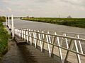
Several drains connect to the River Witham. These drains have special flood doors that close if the river level gets too high. Some of these drains can be explored by adventurous boaters. The Kyme Eau also connects to the Witham, and it will eventually link to the Sleaford Navigation. At Antons Gowt, a lock leads into the Witham Navigable Drains, which are used to prevent flooding in the fenlands north of Boston.
Water Quality
The Environment Agency checks the water quality of rivers in England. They give each river a rating: high, good, moderate, poor, or bad. This rating looks at things like the types of plants, animals, and fish in the water, and the levels of chemicals.
In 2016, parts of the River Witham had different water quality ratings:
| Section | Ecological Status | Chemical Status | Overall Status | Length |
|---|---|---|---|---|
| Witham - headwaters to conf Cringle Bk | Poor | Good | Poor | 13.3 miles (21.4 km) |
| Witham - conf Cringle Bk to conf Brant | Moderate | Good | Moderate | 35.4 miles (57.0 km) |
| Witham - conf Brant to conf Catchwater Drain | Moderate | Good | Moderate | 4.1 miles (6.6 km) |
| Witham 1st and 3rd IDBs draining to the River Witham | Moderate | Good | Moderate | 33.3 miles (53.6 km) |
| Lower Witham | Moderate | Good | Moderate | 10.8 miles (17.4 km) |
| Witham | Bad | Good | Bad |
The water quality is not always "good" because of things like sewage, changes made to the river for drainage, and water running off farms. In 2018, there was a very serious pollution event when a company accidentally released a chemical into the river. This caused over 100,000 fish to die. The company was told to fix the damage, and many new fish were released into the river to help it recover.
Points of Interest
| Point | Coordinates (Links to map resources) |
OS Grid Ref | Notes |
|---|---|---|---|
| Source | 52°45′39″N 0°41′29″W / 52.7608°N 0.6914°W | SK884189 | |
| South Witham bridge | 52°45′58″N 0°37′39″W / 52.7660°N 0.6275°W | SK927195 | |
| A1 bridge, Colsterworth | 52°49′05″N 0°37′25″W / 52.8181°N 0.6235°W | SK928254 | |
| A52 bridge, Grantham | 52°54′15″N 0°37′54″W / 52.9041°N 0.6317°W | SK921349 | |
| Railway bridge, Barkston | 52°58′18″N 0°37′51″W / 52.9716°N 0.6309°W | SK920424 | |
| Long Bennington bridge | 52°58′18″N 0°37′51″W / 52.9716°N 0.6309°W | SK920424 | |
| A17 bridge, Beckingham | 53°04′35″N 0°41′48″W / 53.0764°N 0.6967°W | SK874540 | |
| Haddington bridge | 53°09′16″N 0°37′40″W / 53.1545°N 0.6278°W | SK918628 | |
| Jn with River Brant | 53°09′46″N 0°34′37″W / 53.1627°N 0.5769°W | SK952637 | |
| Brayford Pool | 53°13′41″N 0°32′38″W / 53.2281°N 0.5438°W | SK973711 | |
| Stamp End Lock, Lincoln | 53°13′41″N 0°31′47″W / 53.2280°N 0.5296°W | SK982711 | |
| Bardney Lock | 53°12′59″N 0°20′54″W / 53.2164°N 0.3483°W | TF103700 | |
| Jn with Horncastle Canal | 53°05′00″N 0°11′48″W / 53.0832°N 0.1967°W | TF208555 | canal derelict |
| Jn with Sleaford Navigation | 53°04′10″N 0°11′46″W / 53.0695°N 0.1961°W | TF209539 | |
| Jn with Witham Navigable Drains | 53°00′29″N 0°03′51″W / 53.0081°N 0.0641°W | TF299473 | |
| Grand Sluice | 52°58′54″N 0°01′50″W / 52.9818°N 0.0306°W | TF323445 | Start of The Haven |
| Jn with The Wash | 52°55′56″N 0°04′36″E / 52.9322°N 0.0768°E | TF396392 |
Images for kids
-
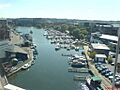
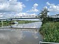
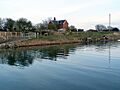
Brayford Pool: Where the Witham meets the Fossdyke.
-
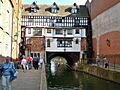
The medieval High Bridge in Lincoln, called The Glory Hole because it's so low.
-
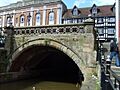
The downstream view of the Glory Hole.
-
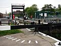
Stamp End Lock in Lincoln.
-
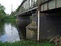
Five Mile Bridge, near Fiskerton.
-
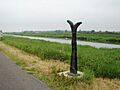
A Sustrans signpost on the cycle path next to the Witham.
-
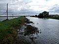
Flooding at Short Ferry in July 2007.
-
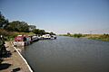
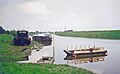
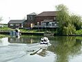
Moorings on the River Witham by Bardney Lock.
-
Both courses of the river at Bardney Lock.
-
Bardney sugar factory, which used to use the river.
-
Stixwold Ferry in 1967.
-
The former railway station at Southrey.
-
Sluice gate for the Kyme Eau.
-
Day mooring at Southrey.
-
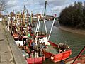
People taking part in the Boston Rowing Marathon near Stixwould.
-
Old and new bridges at Tattershall.
-
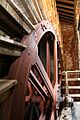
The Scoop wheel of the Dogdyke Engine.
-
Riverside pub at Dogdyke, where the Horncastle Canal used to join.
-
Langrick Bridge.
-
The Haven, the tidal waters below the Witham.


Tributaries
- Foston Beck
- River Brant
- Fossdyke Navigation, a canal that uses part of the lower River Till
- Barlings Eau
- River Bain
- Kyme Eau, a part of the River Slea that flows through the fens
The following flow into The Haven:
- South Forty-Foot Drain
- Maud Foster Drain (part of Witham Navigable Drains)
- Hobhole Drain (part of Witham Navigable Drains)
See also
 In Spanish: Río Witham para niños
