
River Till, Lincolnshire facts for kids
Quick facts for kids River Till |
|
|---|---|

The bridge carrying Broxholme Lane over the River Till
|
|
| Country | England |
| Counties | Lincolnshire |
| Physical characteristics | |
| Main source | Corringham 66 ft (20 m) |
| River mouth | Brayford Pool, Lincoln 13 ft (4.0 m) 53°13′48″N 0°32′56″W / 53.2300°N 0.5488°W |
The River Till is a river found in Lincolnshire, England. It eventually flows into the River Witham. The river starts by draining land to the east of Gainsborough. In its middle part, the river has high banks because the water level is often higher than the land around it. Special pumps move water from lower drainage ditches into the river. The lower part of the river, from a small village called Odder near Saxilby to the city of Lincoln, was made into a canal. This might have happened as far back as Roman times and is now part of the Foss Dyke.
Most of the River Till is looked after by the Environment Agency. This is because it is a "main river." The upper part of the river and the drainage ditches nearby are managed by the Upper Witham internal drainage board. To help protect Lincoln from floods, a special gate called a sluice was built at a place called Till Washlands. When there's a risk of flooding, this gate closes. Other gates then let water spread out onto nearby farmland. This stops the city from flooding. These flood defences were first used in 2000. They successfully protected Lincoln during heavy floods in 2007.
There are some problems with the water quality in parts of the river. This is mainly due to water running off farms, changes made to the river channel, and water released from sewage treatment plants. In 2011, an area of the river near Saxilby was taken over by an invasive plant called Azolla. To fix this, an environmental project released about 8,000 Azolla weevils (a type of beetle) into the river. These weevils only eat the Azolla fern. Once they eat all the fern, they die off naturally without harming other plants or animals.
Contents
Journey of the River Till
The River Till begins as several small streams. These streams are near Corringham, Lincolnshire, which is east of Gainsborough. The river flows south, going under a bridge near Heapham Windmill. This windmill is a very old building from around 1878. The river then flows west of Heapham village.
Sturgate Airfield is on the east side of the river. The river turns east for a short bit, then south again. It flows under Cow Lane and passes by Upton Sewage Treatment Works. It then goes under Glentworth Road, east of Kexby. The river continues to Willingham by Stow. Here, it flows around the edge of the village and under two more bridges. Another sewage treatment works is located on the river's eastern bank. South of the village, another stream joins the Till. This stream flows under the B1241 Stow Road.
The river then turns southeast, going under another small road. It turns south again towards Squire's Bridge on Ingham Road in Stow. The river flows east of Sturton by Stow. It is crossed by a small road at Thorpe Bridge and by the A1500 road. This road used to be a Roman road. The Till passes east of Bransby and is joined by another stream from its eastern side. Then, it flows west of Broxholme.
Northeast of Saxilby, Broxholme Lane crosses the river. The river then flows through a special flood defence gate called a sluice. This sluice helps to flood nearby lands on purpose. This stops the city of Lincoln from flooding. After the sluice, there is a pumping station for land drainage. Another bridge, also carrying Broxholme Lane, crosses the river. The A57 road runs along the north side of the Foss Dyke. It crosses the Till where the Till joins the Foss Dyke.
The last part of the River Till is usually called the Foss Dyke. This section can be seen as the Till's lower part that was made into a canal. People often think the Foss Dyke was built in Roman times, but its current shape is from the 1700s. This part of the river flows southeast. There is a marina called Burton Waters, built next to a housing area. The Lincoln to Gainsborough railway line runs along the south bank. Both the river and the railway are crossed by the A46 road. A bridge carries the Foss Dyke over a drainage channel called the Main Drain. The A57 road crosses again as the river enters Brayford Pool. This is a wider part of the River Witham in the middle of Lincoln.
River Till's History and Flood Protection
The River Till drains an area of Lincolnshire. This area stretches from Gainsborough in the northwest to Lincoln in the southeast. In Lincoln, the Till joins the River Witham at Brayford Pool. The river is surrounded by earth banks on both sides. These banks make the river wider and stop floodwater from spreading onto the land. These banks go from Stow Road Bridge to where the Till meets the Foss Dyke.
Lincolnshire had very bad floods in 1795. The River Trent broke its banks, flooding about 20,000 acres of land between the Trent and Lincoln. This included swampy areas at Broxholme and land at Saxilby. Lincoln High Street acted like a dam, holding the water west of the city. Water levels on the Foss Dyke were about 8 feet higher than normal. The floodwater stayed there for almost three weeks.
After this disaster, a law was passed in 1804. This law created two drainage boards. The Lincoln West (North District) board was in charge of about 1,540 acres around the Foss Dyke and River Till. The Lincoln West (South District) board looked after 2,330 acres along the upper Witham. These boards had to build banks and drain the land. The banks of the Till were made longer in the 1900s. However, most of the banks below Tillbridge were already there by 1886.


Water from land south of the Till used to drain into the Sincil Dyke through a tunnel under the River Witham. To drain land to the north better, the North District board was allowed to build a cast-iron tunnel under the Foss Dyke at Bishop Bridge. They also built a main drain to connect it to the South District's main drain. They also built a higher drain to catch water running off high ground. This drain empties into the Foss Dyke at Bishop Bridge. When this work was finished, the drainage system was much like it is today.
Many drains had special gates called sluice doors. These doors opened and closed automatically or by hand. Before 1930, some water was pumped from the land at Broxholme and Saxilby by landowners. But during floods, water levels in the main drains rose quickly. The pumps often could not be used when they were needed most.
A new law in 1930 made things simpler. The Witham and Steeping Rivers Catchment Board became responsible for the whole area. The Upper Witham Internal Drainage Board was set up to manage land drainage from 1933. The old North and South District Boards were removed. Over the years, different groups managed the rivers. These included the Lincolnshire River Board, the Lincolnshire River Authority, Anglian Water Authority, the National Rivers Authority, and finally the Environment Agency from 1996. The Environment Agency now looks after most of the Till and its main drains. The Upper Witham internal drainage board is responsible for the upper river and many smaller drainage ditches.
About 20,000 people live in parts of Lincoln that can flood. Many of the city's factories and half of its shops are also at high risk. Lincoln had big floods in 1947 and 1958. The amount of water from the River Till was a major reason for the 1958 floods. After these events, studies were done in 1977 to find ways to stop flooding in the city.
This led to building two special areas called washlands. One is where the River Brant joins the River Witham, south of Lincoln. The other is on the River Till, northwest of Lincoln. Work started in 1984. These two areas can hold back about 340 million cubic feet of floodwater. In both places, a low bank was built across the river valley. The river flows through a control sluice, which can limit how much water goes downstream. Gates in the banks can be opened to let water flood the Till washlands. This stops river levels in the city from getting too high. The water from the washlands is then released when levels in the city return to normal. Pumps help drain the washlands. The whole project was finished in 1991.
The washlands were first used in 2000. There was some local flooding in rural areas, but storing the water stopped major damage in Lincoln. A much more serious flood happened in 2007 because of very heavy rain. But the flood defences worked as planned. The River Till reservoir filled to 85 percent before water levels went down. The washlands were partly filled again in January 2008. A study in 2010 suggested that the washlands should be made even bigger. This would help them deal with the possible effects of climate change.
River Till Water Quality
The Environment Agency checks the water quality of rivers in England. Each river gets an overall "ecological status." This can be high, good, moderate, poor, or bad. Many things are used to decide this. These include the types and numbers of invertebrates (like insects), flowering plants, and fish. Chemical status is also checked. This compares the amount of different chemicals to safe levels. Chemical status is either "good" or "fail."
Here is how the water quality of the River Till system was in 2016:
| Section | Ecological Status | Chemical Status | Overall Status | Length | Catchment | Channel |
|---|---|---|---|---|---|---|
| Tributary of Till | Poor | Good | Poor | 3.0 miles (4.8 km) | 6.62 square miles (17.1 km2) | |
| Till (Witham) | Moderate | Good | Moderate | 8.8 miles (14.2 km) | 13.60 square miles (35.2 km2) | heavily modified |
| Fillingham Beck | Moderate | Good | Moderate | 1.5 miles (2.4 km) | 9.39 square miles (24.3 km2) | heavily modified |
| Lower Till | Moderate | Good | Moderate | 6.8 miles (10.9 km) | 19.62 square miles (50.8 km2) | heavily modified |
| Fossdyke Canal, River Till section | Good | Good | Good | 4.3 miles (6.9 km) | artificial |
The water quality is not always good for several reasons. These include water running off farms, changes made to the river channel for drainage, and sewage being released into the lower parts of the river.
In 2011, about 2.5 miles of the Till near Saxilby were covered by a plant called Azolla. This is a fast-growing water fern that came to Britain from America in the 1840s. It was used in garden ponds. In the river, it formed thick mats. These mats stopped other river plants and animals from getting enough oxygen and light. To fight this, the Environment Agency released 8,000 Azolla weevils (Stenopelmus rufinasus) into the affected area. These weevils only eat the Azolla fern. They were expected to grow quickly into millions of weevils in a few weeks. Because they only eat Azolla, they die out naturally once the fern is gone. This means they do not harm other native plants or animals. Earlier attempts to clear the weed by machines in June 2011 had not worked well.
Images for kids
-
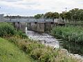
The Till Washlands main sluice allows the flow of the river to be stopped during a flood event.
-
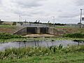
The west sluice allows washland to be flooded to the west of the river to protect the city of Lincoln.
