Witham Navigable Drains facts for kids
Quick facts for kids Witham Navigable Drains |
|
|---|---|

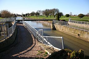
Cowbridge Aqueduct carries the Stonebridge Drain over the Cowbridge Drain
|
|
| Specifications | |
| Maximum boat length | 70 ft 0 in (21.34 m) |
| Maximum boat beam | 10 ft 0 in (3.05 m) |
| Locks | 2 (3 other locks are defunct) |
| Status | Navigable in summer |
| Navigation authority | Witham Fourth District IDB |
| History | |
| Original owner | Witham Fourth Drainage District |
| Principal engineer | various |
| Date of act | 1801 |
| Date of first use | 1780s |
| Geography | |
| Start point | Anton's Gowt, Boston |
| End point | various |
The Witham Navigable Drains are a network of waterways in Lincolnshire, England. They are part of a much bigger system that helps drain water from the land. This area is managed by the Witham Fourth District Internal Drainage Board.
The district covers about 97 square miles (250 km²) of flat, low-lying land called fens. There are over 438 miles (705 km) of drainage ditches in total. But only about 60 miles (97 km) of these can be used by boats. You can usually only navigate these drains in the summer. In winter, the water levels are kept lower to prevent flooding. This means boats can get stuck easily. You can get onto the drains from the River Witham at Anton's Gowt Lock.
Contents
What are the Fens?
The area where these drains are located is called fenland. Most of it is very flat, almost at sea level. It's surrounded by the River Witham to the south and west. To the north, you'll find places like Coningsby and Spilsby.
The fenland is split into two main parts: the East Fen and the West Fen. A strip of higher ground separates them. This higher ground is where villages like Stickford and Sibsey are located. Historically, much of this land was a huge common. People from nearby villages could let their animals graze there. But they could only do this in summer. In winter, the fens would often flood.
A History of Draining the Land
For hundreds of years, this area has faced problems with flooding. Water came from both rivers and the sea. People started building defenses against floods as early as the 11th and 12th centuries. Monks built sea banks to protect their farms.
In the 13th century, special groups called Commissions of Sewers were set up. Their job was to fix drainage problems. They could hire workers and decide how to pay for the work. Big floods in 1394 led to a new floodgate being built at Waynflete.
Early Drainage Efforts
In the 16th century, people tried to make the drains bigger. The Maud Foster drain was dug in 1568. But by 1631, it wasn't enough, and there was a lot of flooding. Some people, called "Adventurers," were hired to improve the Maud Foster drain. They were given land in return for their work. They spent a lot of money and got a lot of land.
However, not everyone was happy. In 1642, many locals who used the land for grazing formed a mob. They destroyed sluices, houses, and crops. This included the new Maud Foster sluice. The Adventurers tried to get help from the government, but the locals won in court. This meant the drains stayed ruined for many years.
The Maud Foster drain was widened again in 1734. In 1762, the Witham Fourth Drainage District Commissioners were created. They were in charge of drainage for some areas.
Using Drains for Boats
As the drains became wider, people started thinking about using them for boats. In 1779, someone suggested building a lock at Anton's Gowt. A lock is like a water elevator that helps boats move between different water levels. Money wasn't available then, so simple "land doors" were used. The lock was finally finished in 1813.
Modern Engineering for the Drains
In the late 1700s, engineers like John Smeaton and John Rennie studied the fens. They looked for ways to improve drainage. Sir Joseph Banks, a famous scientist, pushed for a solution. In 1800, John Rennie suggested building new drains and sluices. A sluice is a gate that controls water flow.
His plan led to an Act of Parliament in 1801. This law allowed for major engineering work. Key projects included:
- The West Fen Catchwater Drain (about 13.4 miles or 21.6 km long).
- The East Fen Catchwater Drain (about 9.4 miles or 15.1 km long).
- The Stonebridge Drain (about 4.2 miles or 6.8 km long).
- Improvements to the Maud Foster drain and a new sluice.
- The Hobhole Drain (about 13.5 miles or 21.7 km long) with a new sluice.
Most of the main drains you can navigate today were built or improved during this time. The Hobhole Sluice opened in 1806, and Rennie's new Maud Foster Sluice was ready in 1807.
The Power of Pumps
The first time a steam engine was used for fen drainage was at Hobhole sluice in 1806. A small 6-horsepower engine pumped water out to help build the sluice's foundations.
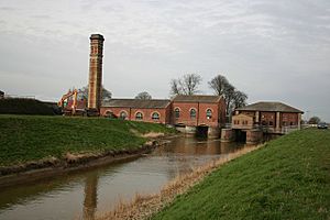
In the 1860s, steam engines became more common. They were used to pump water from the fens. This was important because the land was slowly sinking. In 1867, a big pumping station was built at Lade Bank. It had two powerful steam engines that could pump 350 tons of water per minute!
Later, these steam engines were replaced by diesel engines. Today, many pumps use electricity. In the 1980s and 1990s, some pumping stations were beautifully restored. The Witham Fourth District IDB even won an award for their design work.
Boating on the Drains
In the past, these drains were used to bring coal to the fens and take farm products out. Now, they are mostly used for pleasure cruising. This means people use them for fun boat trips.
Cruising is usually only possible from April to October. During these months, water levels are kept higher for irrigation (watering crops). From October to April, the levels are lowered to handle heavy rainfall. This makes the water too shallow for most boats. Also, the water levels can change quickly, which can be tricky for boaters.
Anton's Gowt lock is quite large, 75 feet (23 m) long and 18 feet (5.5 m) wide. However, most of the drains are not wide enough for such big boats. The only other working lock is at Cowbridge. It is 70 feet (21 m) long and 10 feet (3 m) wide. This lock lets boats get onto the Maud Foster drain and visit Boston. From Cowbridge Lock, you can also explore the Lincolnshire Wolds using other drains.
Some drains, like Cowbridge Drain and Hobhole Drain, used to be navigable. But they are now cut off because East Fen Lock has been filled in. Another lock near Lade Bank pumping station was turned into a sluice.
Boating can have challenges. Some bridges are very low, less than 6 feet (1.8 m) high. If the water level rises, boats might not fit under them. Also, sometimes there aren't places to turn around at the end of a drain. Weeds can also grow thick in some channels, making it hard to move. But sometimes, a drain that was full of weeds gets cleared for drainage, and then it's suddenly open for boats again!
Interesting Structures Along the Drains
Many of the structures built by John Rennie in the early 1800s are still standing. They are important historically, so they are now Grade II listed. This means they are protected because of their special value.
You can see red-brick bridges with stone tops. On the Hobhole Drain, Freiston Bridge has three arches. Other bridges like Ings Bridge and Station Bridge have a single arch. The original Hobhole Sluice, built in 1805, is still there.
On the Cowbridge Drain, Baker's Bridge has three arches. Mastin's Bridge has one arch. On the Maud Foster Drain, Rawson's Bridge is an original single-arch bridge. Bargate Bridge carries the A16 road over the drain in Boston. Part of this bridge was widened in 1972, but they used the original design.
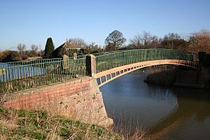
Two old footbridges made of cast iron in 1811 are still around. They were made by the Butterley Company. One is Hospital Bridge in Boston, and the other is near Cowbridge Lock. You can even see "CAST AT BUTTERLEY 1811" stamped into their metal beams! The Maud Foster sluice is also mostly original. It has three arches with wooden gates that are raised and lowered by pulleys. The entrance lock at Anton's Gowt is also a listed structure.
A special bridge called Nunn's Bridge crosses the Hobhole Drain. Built in 1948, it was the first bridge in Britain made of pre-stressed concrete that was poured right on site.
Location Map
| Point | Coordinates (Links to map resources) |
OS Grid Ref | Notes |
|---|---|---|---|
| Antons Gowt Lock | 53°00′32″N 0°03′50″W / 53.009°N 0.064°W | TF300474 | |
| Maud Foster Sluice | 52°58′05″N 0°00′47″W / 52.968°N 0.013°W | TF335430 | |
| Hobhole Pumping Station | 52°56′20″N 0°01′52″E / 52.939°N 0.031°E | TF366399 | |
| Cowbridge Lock | 53°00′18″N 0°01′19″W / 53.005°N 0.022°W | TF328471 | |
| Lade Bank Pumping Station | 53°04′12″N 0°03′25″E / 53.070°N 0.057°E | TF379544 | |
| Revesby Bridge | 53°07′26″N 0°03′00″W / 53.124°N 0.050°W | TF306603 | |
| Leverton Pumping Station | 53°00′14″N 0°08′12″E / 53.0039°N 0.1366°E | TF434473 | |
| Wrangle Pumping Station | 53°02′08″N 0°11′17″E / 53.0355°N 0.1881°E | TF468509 | |
| Bennington Pumping Station | 52°58′44″N 0°06′38″E / 52.9788°N 0.1105°E | TF418444 | |
| Thorpe Culvert Pumping Station | 53°07′16″N 0°11′49″E / 53.1211°N 0.1970°E | TF471604 |
 | Delilah Pierce |
 | Gordon Parks |
 | Augusta Savage |
 | Charles Ethan Porter |


