South Forty-Foot Drain facts for kids
Quick facts for kids South Forty-Foot Drain |
|
|---|---|

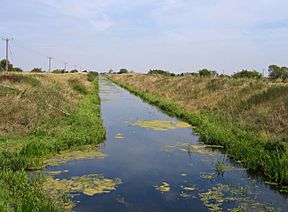
The South Forty-Foot Drain at Pointon, between Boston and Guthrum Gowt. Here its origin as a drainage channel is very evident.
|
|
| Specifications | |
| Maximum boat length | 70 ft 0 in (21.34 m) |
| Maximum boat beam | 20 ft 0 in (6.10 m) |
| Locks | 1 (1 or 2 more locks will be required when the drain is joined to the River Glen) |
| Maximum height above sea level | −1 ft (−0.30 m) |
| Status | Under restoration |
| Navigation authority | Environment Agency |
| History | |
| Original owner | Black Sluice Commissioners |
| Principal engineer | Earl of Lindsey |
| Date of act | 1765 |
| Date of first use | 1846 |
| Date completed | 1770 |
| Date closed | 1971 |
| Date restored | March 2009 |
| Geography | |
| Start point | The Haven, Boston |
| End point | Guthram Gowt |
The South Forty-Foot Drain, also known as the Black Sluice Navigation, is a very important channel. It helps drain water from a large area of low-lying land called the Black Sluice Level in the Lincolnshire Fens. This area is in eastern England, between a place called Guthram Gowt and the Black Sluice pumping station in Boston.
The idea for the Drain started way back in the 1630s. This was when the first plan to make the Fen land good for farming began. A person called the Earl of Lindsey led this effort. Since then, the Drain has been steadily improved. For a long time, water flowed out into The Haven (a river) by itself when the tide was low. But in 1946, the Black Sluice pumping station was built to pump the water out.
The Drain was used by boats until 1971. That's when the entrance lock was removed because the pumping station was being improved. Now, the Environment Agency is upgrading it again so boats can use it. This is part of a bigger project called the Fens Waterways Link. A new entrance lock was finished in December 2008. This lock lets boats travel on the first 12 miles (19 km) of the Drain. The next part of the project will connect the Drain to the River Glen. This will allow boats to travel all the way to Spalding.
Contents
History of the South Forty-Foot Drain
The Lincolnshire Fens are very flat and low. They have often been flooded for hundreds of years. People have always tried to stop this flooding. In the Middle Ages, a ditch called the Midfen Dyke was built to drain the area. But by the 1500s, it was more of a boundary marker than a drain. It marked the border between two old areas of Lincolnshire, Holland and Kesteven.
The first big effort to drain the land southwest of Boston happened from 1635 to 1638. This area is now called the Black Sluice Area. The Earl of Lindsey made a deal to drain 36,000 acres (146 km²) of land for farming. The Earl and a group of people called "Adventurers" paid for the work. In return, they received grants of land.
The work cost £45,000. It included building a sluice (a gate to control water) near Boston, called Skirbeck Sluice. They also built the first 8 miles (13 km) of the South Forty-Foot Drain. This ran from Boston to Great Hale. Two more drains, called the Double Twelves, were built from there to Guthram. The Clay Dyke Drain was also built.
Local people, called fenmen, were not happy. They made a living from fishing and hunting wild birds. Commoners also had rights to graze animals on the common land when it wasn't flooded. They tried to get Parliament to help them. But after three years, they gave up on legal action. Instead, they took direct action. They destroyed much of the work, including buildings and crops. They even burned Skirbeck Sluice. The Earl of Lindsey's contract was cancelled. It was another 100 years before anyone tried to drain the area again.
In 1720, another person, Earl Fitzwilliam, tried to drain Holland Fen. He also wanted to stop flooding from the River Witham. He built a drain that ran next to the River Witham. It ended at Lodewick's Gowt, a sluice he built on the Witham. This drain was called Earl Fitzwilliam's drain for many years. Now, it's known as the North Forty-Foot Drain. But this plan wasn't completely successful either.
Better Drainage with New Sluices
In 1762, a new law was passed by Parliament. It set up groups of people to manage drainage in different areas. In 1763, a huge flood covered much of the land southwest of Boston. Because of this, the Black Sluice Drainage and Navigation Act 1765 was created. This law set up the Black Sluice Commissioners. They could collect taxes and carry out drainage work. Their plan was very similar to the Earl of Lindsey's original idea.
Engineers Langley Edwards and John Landen designed the work. A new sluice, called the Black Sluice, was built in Boston. It replaced the old Skirbeck Sluice. The new sluice had three openings, 40 feet (12 m) wide in total. The first 8 miles (13 km) of the Drain were cleaned out. Beyond that, the Main Drain was improved by digging a new 14-mile (23 km) channel. This extended the South Forty-Foot Drain all the way to Guthram. About 65 miles (105 km) of smaller streams were also improved. The work cost more than expected, but it was finished by 1770. A historian later wrote that the work was "well-designed" and "entirely answered expectation."
Around the same time, the Grand Sluice was built on the River Witham in 1766. This stopped tidal water from entering the river and flooding Holland Fen. Improvements to The Haven in Boston also helped. They lowered the water levels at the Black Sluice. This made the South Forty-Foot Drain work even better.
Water was pumped into the Drain using many windmills with scoop wheels. Maps from 1783 show 46 such mills. They drained 32,000 acres (130 km²) of farmland. But big floods in 1810 and 1820 showed that more improvements were needed.
Modern Drainage and Pumping Stations
In 1846, a new Black Sluice was built. It included a 20-foot (6.1 m) wide lock for boats. This new sluice was built lower than the old one. This made the South Forty-Foot Drain steeper, helping water flow faster. Many smaller drains were also improved.
The year 1846 also marked the start of using steam engines for pumping water. Ten years later, a map showed nine steam-powered and eight wind-powered drainage engines in use. Later, oil and paraffin engines replaced steam and wind engines. By 1935, there were 15 such engines.
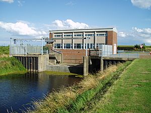
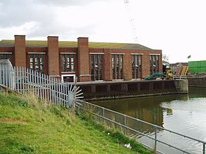
In 1939, the Black Sluice and the South Forty-Foot Drain came under the control of the Rivers Board. Even with World War II happening, a big project was completed in 1946. This project built the Black Sluice pumping station. It also widened 11 miles (18 km) of the Drain. The pumping station had three huge pumps. Each was powered by a 900-horsepower (670 kW) diesel engine.
In the 1950s, electric pumps started to replace oil and paraffin engines. More pumping stations were built to improve drainage for an extra 11,000 acres (45 km²) of land. In the 1960s, even more improvements were made. Two extra pumps were added at the Black Sluice. The Drain was widened further. This work helped prevent flooding during very wet weather in 1968/69. The upgraded pumping station can now pump 800,000 gallons (3,000,000 litres) of water per minute!
Control of the Drain and sluice changed hands over the years. It went to the National Rivers Authority in 1990 and then to the Environment Agency in 1995.
Even with all these improvements, serious flooding happened in 1999. The bank of the Drain broke near Pinchbeck. Workers quickly repaired it before homes were flooded. After this, a review was done. It suggested improving some of the banks. However, money for the work wasn't available at that time.
What the Drain Does
The South Forty-Foot Drain also acts like a border for much of its length. South of Donington High Bridge, it separates South Kesteven from South Holland. North of Donington, it separates the borough of Boston from North Kesteven.
The main job of the Drain is to collect water. It gathers water pumped from the Kesteven Fens, the Holland Fens, and the Weir Dyke. This water flows north and east to the Black Sluice in Boston. From there, it's released into the tidal waters of The Haven. The Weir Dyke got its name from a weir (a small dam) that used to let water overflow from the Bourne Eau when there was too much water. This weir is no longer needed since a pumping station was built in 1966.
The Environment Agency is in charge of the South Forty-Foot Drain and the Black Sluice pumping station. They also manage most of the smaller channels that flow into the Drain. The Black Sluice Internal Drainage Board manages the smaller drainage ditches in the Fens. They maintain 34 pumping stations and three gravity stations in the area. Many of these pump water directly into the Drain.
Boating on the Drain
Before 1971, boats could use the Drain. In 1939, it was listed as being open for 21 miles (34 km). Boats up to 70 feet (21 m) long and 18 feet (5.5 m) wide could use it up to Donington Bridge. Beyond that, the water was shallower. Only commercial boats were allowed to use it; pleasure boats were not.
Navigation stopped in 1971 when the lock was closed and removed. Not many people protested at the time. More recently, groups like the East Anglian Waterways Association suggested making the Drain navigable again. This would be part of a larger plan to improve leisure activities in the Fens. A study was done, and the plan was officially adopted as the Fens Waterways Link in 2004.
This big project involves 150 miles (240 km) of waterways. About 50 miles (80 km) will be new routes for boats. The rest will be existing waterways that are improved. When finished, it will connect the Rivers Witham, Glen, Welland, Nene and Great Ouse. The Environment Agency called it the biggest waterway improvement project in Europe.
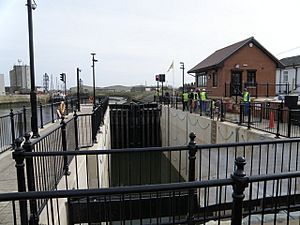
In 2007, they got money to build the link between Boston and Spalding. Work on a new lock next to the Black Sluice pumping station in Boston started in February 2008. It was finished in December 2008 and officially opened in March 2009. This lock cost £8.5 million. It lets boats travel between The Haven and the South Forty-Foot Drain. The lock has special gates that weigh 12.1 tonnes each.
The new lock opened up almost 12 miles (19 km) of waterway. New places for boats to moor (tie up) were built. These are at The Haven, near the Black Sluice pumping station, at Swineshead Bridge, and at Hubbert's Bridge.
At first, boats could only go as far as Donington High Bridge. This is where the Swaton Eau joins the Drain, making it wide enough for boats to turn around. Beyond the bridge, the Drain was only for canoes and kayaks. However, in 2009, eight narrow boats successfully traveled further. They reached Kingston's Bridge, about 3.7 miles (6.0 km) past Donington. There, the outlets from pumping stations made the Drain wide enough for a 70-foot (21 m) boat to turn.
The Environment Agency has renamed the Drain the Black Sluice Navigation. If you want to use it, you need a license from the Environment Agency. There are no permanent places to moor boats, so licenses are for one or seven days.
Water levels in the Drain are kept lower in winter. This is because there's more rain, and the Drain needs to handle more water. In summer, water levels are kept higher for boats. This change usually happens at the beginning of April.
Old Ideas for Connections
The idea of connecting the South Forty-Foot Drain to the River Nene is not new. Plans for such a link were first suggested in 1809. There were proposals for new canals that would connect different waterways. These ideas were discussed again in 1815 and 1828, but nothing ever came of them.
Where the Drain Goes
| Point | Coordinates (Links to map resources) |
OS Grid Ref | Notes |
|---|---|---|---|
| Tongue End | 52°45′14″N 0°17′20″W / 52.754°N 0.289°W | TF155187 | Weir Dyke near where Bourne Eau joins the River Glen |
| Guthram | 52°47′17″N 0°15′54″W / 52.788°N 0.265°W | TF170225 | Engine Drain and Weir Dyke join to form South Forty-Foot Drain (SFF) |
| Caswall's Bridge | 52°49′55″N 0°16′16″W / 52.832°N 0.271°W | TF165274 | Pumping stations on both sides of the SFF |
| Kingston's Bridge | 52°50′56″N 0°16′34″W / 52.849°N 0.276°W | TF162293 | The Twenty Foot Drain is a re-used part of the Lindsey Level works |
| Donington High Bridge | 52°54′18″N 0°15′25″W / 52.905°N 0.257°W | TF173356 | SFF will be widened from here to Guthram as part of Fens Waterways Link |
| Eau End | 52°56′02″N 0°14′31″W / 52.934°N 0.242°W | TF182388 | The drain to the east was a part of the Medieval Midfen Dyke |
| Wragmer Stake | 52°57′22″N 0°13′26″W / 52.956°N 0.224°W | TF184413 | The SFF turns to the north east |
| Bicker Haven | 52°58′01″N 0°12′07″W / 52.967°N 0.202°W | TF208426 | The SFF turns east to Boston |
| North Forty-foot drain | 52°58′12″N 0°02′42″W / 52.970°N 0.045°W | TF314431 | The junction between the two systems |
| Black Sluice | 52°57′58″N 0°01′34″W / 52.966°N 0.026°W | TF326428 | End of the SFF and Site of a new lock |
 | Kyle Baker |
 | Joseph Yoakum |
 | Laura Wheeler Waring |
 | Henry Ossawa Tanner |


