
River Glen, Lincolnshire facts for kids
Quick facts for kids River Glen |
|
|---|---|

The pumping station at Tongue End, which marks the head of navigation, and the point at which the Bourne Eau joins the River Glen.
|
|
| Country | England |
| Physical characteristics | |
| Main source | Ropsley and Boothby Pagnall |
| River mouth | River Welland, below Spalding |
The River Glen is a river in Lincolnshire, England. A small part of it also flows through Rutland near Essendine.
Contents
What's in a Name? The River Glen's Story
The name of the River Glen likely comes from an old Celtic language. This is the same language family that modern Welsh, Cornish, and Breton come from.
Interestingly, the Glen and its nearby river, the Welland, seem to have been named to show how different they are. The Welland flowed from areas with sandy soil that often had a lot of iron. This meant the Welland carried a lot of sediment (like mud and sand) down to the Fens. In modern Welsh, the word gwaelod means "bottom" or "sediment." So, the Welland might have been named for its silty, muddy water.
In contrast, the River Glen flowed from areas with clay and limestone. These areas often had woodland or grassland, so the Glen didn't pick up as much sediment. The modern Welsh word for "clean" is glân. This suggests the River Glen was named for its clear, clean water.
Where Does the River Glen Flow?

The River Glen actually starts in two main branches, both in the low hills of Jurassic rocks in western Lincolnshire.
The East Glen River
The East Glen starts as several small streams near Ropsley and Great Humby. It flows south, passing by Ingoldsby and Bulby, before reaching Edenham. Sometimes, people call the East Glen the River Eden because it flows through Edenham. It continues south through Toft and Manthorpe, where you can see old bridges from the early 1800s. Then it turns east to meet the West Glen at Wilsthorpe, Lincolnshire.
The West Glen River
The West Glen also begins from several streams near Old Somerby and Boothby Pagnall. It flows mostly parallel to the East Glen, passing through villages like Bitchfield, Burton-le-Coggles, Corby Glen, and Creeton. It then reaches Essendine, where it turns east towards Greatford. In Greatford, an old stone bridge from the late 1700s crosses the river.
How the Rivers Join and Change
Most of the water from the West Glen doesn't actually join the East Glen anymore. Instead, it flows along a channel called the Greatford Cut to join the River Welland further upstream. This change was made during World War II as part of a big project to control flooding. This project also included digging the Coronation Channel, which helps divert the Welland around Spalding. The Coronation Channel was finished in 1953 and named after the crowning of Queen Elizabeth II.
When the East and West Glen rivers finally meet, they are only about 35 feet (11 meters) above sea level. From there, the combined river flows north past Fletland Mill, an old grain mill built in 1759. It then goes under the A15 road at Kate's Bridge. The old bridge here has a carving of a woman's head, which is thought to be "Kate."
As the river continues, it becomes a typical "high level carrier" for the Fens. This means it's built up with banks on both sides, and its water level is often higher than the land around it. At Tongue End, the water from the Bourne Eau joins the Glen. The river from here to its end is navigable for about 11.5 miles (18.5 km). There used to be a way for boats to go from the Glen to the Bourne Eau, but now a pumping station sits between them to help drain the land.
The River Glen then flows northeast through Pinchbeck and Surfleet. It finally reaches a tidal entrance sluice where it joins the River Welland. Boats can only pass through this sluice when the river and tidal levels are the same.
A Look Back: The River Glen's History
The River Glen has a long history. An old book called Historia Brittonum, written around the 9th century, says that the famous King Arthur fought his first battle against the Anglo-Saxons at the mouth of a river called Glein. Some historians believe this Glein was actually the River Glen.
Compared to the River Welland, there aren't as many old records about the Glen. In 1662, a writer named Dugdale described the Glen as the smallest river he had seen. He noted that it mainly served to carry its own water and the water from the Bourne Eau, kept between two strong banks. This shows that the lower part of the river was already built up with banks a long time ago.
Both the Bourne Eau and the Glen often flooded, causing their banks to break. People tried to fix this with laws like the Black Sluice Act of 1765. The history of boats on the Glen is closely linked to the Bourne Eau, as Bourne was an important town. In 1781, trustees were appointed to clean the river and charge tolls for boats to use it. Goods like corn and wool were sent down the river to Boston, while coal and groceries came back up.
However, river traffic started to decline quickly when railways arrived. A railway from Boston to Spalding opened in 1848, and lines to Bourne opened later. By the 1860s, a sluice was built at Tongue End, stopping boats from going between the Glen and the Bourne Eau. Even though the right to navigate was only officially removed in 1962, this change effectively ended most trade on the river.
Before the route to Bourne closed, boats called lighters, which could carry 15 tons, used to travel as far as Kate's Bridge. There are also signs of old boat moorings at Greatford Hall.
In 1734, a smart engineer named John Grundy designed a plan to drain a large area of fenland near Spalding. His plan included building a reservoir and a sluice at Surfleet. The idea was to release water from the reservoir at low tide to help clean and deepen the river channel, which would improve drainage. This sluice was replaced by the current one in 1824.
How Clean is the River Glen's Water?
The Environment Agency checks the water quality of rivers in England. They give each river an overall "ecological status" (how healthy the environment is) and a "chemical status" (how clean it is from chemicals).
In 2016, the water quality of different parts of the River Glen system was:
- West Glen - Upper: Poor ecological status, good chemical status.
- The Tham: Moderate ecological status, good chemical status.
- West Glen - conf West Glen trib to conf East Glen River: Moderate ecological status, good chemical status.
- Grimsthorpe Park Brook: Good ecological status, good chemical status.
- East Glen River: Poor ecological status, good chemical status.
- Glen: Moderate ecological status, good chemical status.
The main reasons why the water quality isn't always "good" include:
- Sewage being released into the river.
- Physical changes made to the river channels (like straightening them).
- Taking too much water from underground sources.
- Poor management of farmland and rural areas next to the river.
Points of Interest Along the River Glen
| Point | Coordinates (Links to map resources) |
OS Grid Ref | Notes |
|---|---|---|---|
| Surfleet Seas End sluice | 52°50′45″N 0°06′04″W / 52.8458°N 0.1012°W | TF279292 | close to mouth |
| A16 bridge, Surfleet | 52°50′27″N 0°07′21″W / 52.8409°N 0.1226°W | TF265286 | |
| Pinchbeck railway bridge | 52°49′04″N 0°10′06″W / 52.8179°N 0.1684°W | TF235260 | |
| Guthram Gowt | 52°47′13″N 0°15′45″W / 52.7869°N 0.2624°W | TF172224 | |
| Tongue End pumping station | 52°45′16″N 0°17′22″W / 52.7544°N 0.2894°W | TF155187 | outfall from Bourne Eau |
| Fletland Mill | 52°42′59″N 0°22′04″W / 52.7165°N 0.3677°W | TF103144 | |
| Junction of East and West Glen | 52°42′24″N 0°22′49″W / 52.7066°N 0.3804°W | TF095133 | |
| Edenham bridge | 52°47′06″N 0°25′45″W / 52.7849°N 0.4293°W | TF060219 | East Glen |
| East Glen source | 52°53′29″N 0°31′37″W / 52.8915°N 0.5270°W | SK991336 | Ropsley |
| Start of Greatford Cut | 52°41′31″N 0°23′56″W / 52.6919°N 0.3990°W | TF083116 | to Welland at Market Deeping |
| Essendine bridge | 52°42′07″N 0°26′50″W / 52.7019°N 0.4473°W | TF050127 | West Glen |
| Corby Glen bridge | 52°48′43″N 0°31′29″W / 52.8120°N 0.5247°W | SK995248 | West Glen |
| West Glen source | 52°53′31″N 0°33′35″W / 52.8919°N 0.5596°W | SK970336 | Old Somerby |
Images for kids
-
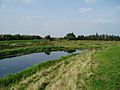
The bend in the river at Guthram Gowt, where the junction with the proposed Fens Link will probably be located.
-
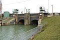
Surfleet Sluice, built in 1824, where the Glen meets the River Welland


