Bourne Eau facts for kids
Quick facts for kids Bourne Eau |
|
|---|---|

The location of the terminus of the Bourne Eau Navigation at Bourne
|
|
| Specifications | |
| Length | 3.5 miles (5.6 km) |
| Original number of locks | 2 |
| Status | Unnavigable |
| History | |
| Original owner | Bourne Eau trustees |
| Date of act | 1781 |
| Date closed | 1860s |
| Geography | |
| Start point | St Peters Pool, Bourne |
| End point | Tongue End |
| Connects to | River Glen, Lincolnshire |
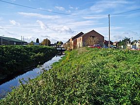
The Bourne Eau is a small river in Lincolnshire, England. It starts from a special kind of spring called an artesian spring in the town of Bourne. From there, it flows east until it joins the River Glen at a place called Tongue End.
Long ago, this river powered three water mills in Bourne. One of these mills is now a heritage center, teaching people about the past. Near Eastgate, the river gets much wider. This was once a busy port for boats in the 1700s and 1800s.
The Bourne Eau is an important part of the drainage system for the surrounding fen lands. These low-lying lands are used for farming. Boats stopped using the river in the 1860s.
The spring that feeds the river gets its water from a deep underground rock layer called a limestone aquifer. This water is very pure and has been used for drinking water in Bourne and Spalding. In the late 1980s, after not much rain, the spring and river dried up.
To fix this, a project in 1992-1993 repaired many old boreholes. These were holes where artesian water was leaking away. By plugging or fixing 30 of these holes, water returned to the spring and the river.
The river acts as a natural border, separating North Fen from South Fen. Both areas were enclosed for farming in the 1770s. Water from North Fen flowed into the South Forty-Foot Drain. Steam pumps were added in 1845 to help with drainage. The Black Sluice Internal Drainage Board (IDB) now manages this area's drainage.
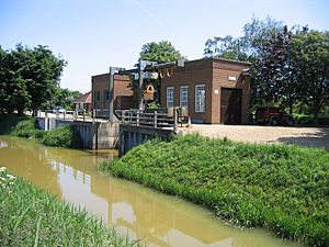
For South Fen, a special tunnel called Gilbert Heathcote's tunnel was built. It carries water under the River Glen. Different engines were used to pump water through this tunnel. After a gas engine broke in 1942, a new pumping station was built. It now pumps water into the River Glen. The Welland and Deepings IDB is now in charge of drainage in South Fen.
Contents
Journey of the Bourne Eau: From Spring to River Glen
The town of Bourne is surrounded by the River Glen. The Bourne Eau starts at a place called The Wellhead, or St Peter's Pool, in Bourne. This is a natural artesian spring. It brings water up from about 165 feet (50 meters) below the ground.
This spring once supplied water for Bourne Castle's defenses. It also powered the town's three mills. One part of the river flows east along the castle's southern edge. Another part flows north, then east and south, circling the castle site. Both branches meet again near Baldock's Mill.
The river then goes under South Street through an old tunnel. It flows along Church Lane, where an old cast-iron bridge from 1832 crosses it. Next to Church Lane is the historic St Peter and St Paul church. This church was built in 1138.
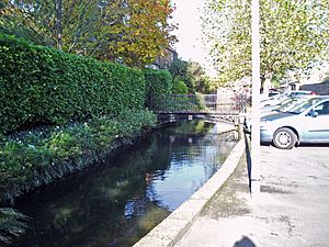
The river goes under more gardens through another old tunnel. When it comes out, it turns south. It flows behind the church and then east, past gardens on Coggles Causeway. A longer, newer tunnel built in the 1960s carries it under the Abbey Lawn sports complex.
After the tunnel, the river passes under Queen's Bridge. Then it runs next to Eastgate. Halfway along Eastgate, the channel widens a lot. This wide part was the main dock when the Bourne Eau was used by boats.
The ancient Roman Car Dyke also passed through Bourne. A modern channel now connects the southern part of the Car Dyke to the river's wide basin. The Anchor Inn, an old pub from the 1700s, sits on the north bank. The A151 Cherry Holt Road crosses the river at May's Sluice.
The river then enters South Fen. Here, another channel links to the Car Dyke on its north bank. Water from Bourne's sewage treatment works also joins the river here. The river is built up with banks on both sides. Smaller drains run alongside these banks. An old railway bridge used to cross the river here, carrying trains to Spalding.
The Bourne Eau finally flows into the River Glen at Tongue End. This name comes from the narrow piece of land between the river banks. Most of the river's water, apart from the spring, comes from the Car Dyke. The Car Dyke collects surface water from higher ground. It sends this water through the Bourne Eau and River Glen to the sea. This stops the water from flooding The Fens.
History of the Bourne Eau: From Ancient Times to Today
The part of the river that flows through South Fen was clearly built by people. It sits higher than the land around it. We don't know exactly when this was first done. In the 1200s, it was called Bourne Ald Ea or Brunne Ea. Orders were given to clean and raise its banks.
In 1765, there was bad flooding when the banks of both the Bourne Eau and River Glen broke. After this, the Black Sluice Commissioners became responsible for the river's north bank. This group was created by an Act of Parliament to manage drainage in the Fens. The north bank was a big problem because it was built on soft peat. This made it hard to raise the bank, and the Bourne Fens often flooded.
In 1781, a new law allowed improvements to the 3.5-mile (5.6 km) river section from the River Glen to Bourne. This law suggested the river had been used by boats before, but had become blocked with mud. Twelve trustees were put in charge. They had to keep the channel 30 feet (9 meters) wide and 5 feet (1.5 meters) deep.
They could charge tolls for boats using the river. The main goods carried were coal and wool, sent to Boston. Boats returning brought coal and groceries. A coal dock was built on Eastgate in the early 1800s. There was also a regular boat service to Spalding market. However, this service was sometimes unreliable due to too much or too little water.
The river had two locks. One was near the River Glen, and the other was closer to Bourne. To help with the north bank problems, flood gates were built at Tongue End. These gates stopped high water from the Glen from flowing back into the Bourne Eau. This helped navigation for a while.
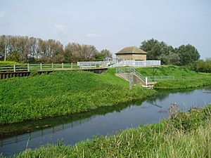
However, trains soon became popular. A railway from Boston to Spalding opened in 1848. A branch line to Bourne opened in 1866. By 1857, boats rarely used the river. The flood gates were replaced by a sluice in the 1860s, which effectively ended boat traffic. The law allowing navigation was removed in 1962. In 1966, the sluice was replaced by a pumping station.
Milling History: Powering Bourne's Mills
The Bourne Eau has powered mills since at least 1086. The Domesday Book recorded three mills in the village back then. In the late 1800s, there were still three corn mills. Cliffe's Mill was demolished in 1910. Notley's Mill, a flour mill, survived until 1973.
Baldock's Mill still stands today. It has been turned into a heritage center. The current building was built in 1800. The mill used to grind animal feed from corn. It had two water wheels. One was a large wooden wheel, 15 feet (4.6 meters) across. The other was a smaller metal wheel.
In 1973, Baldock's Mill became a protected historic building. Students from Bourne Secondary School helped with early restoration work. Bourne United Charities owns the building. Since 1983, the Civic Society has leased it. They have slowly turned it into a heritage center. It celebrates the town's history and its people.
In 2002, the Civic Society decided to restore the water wheels. The large wheel could not be fully rebuilt due to changes in the building. However, the smaller wheel now works. It powers a generator that provides heating for the center.
Water Supply: How Bourne Eau Provides Drinking Water
A lot of the water in the Bourne Eau comes from the spring at St Peters Pool. This spring used to produce about 4.5 million gallons (20.5 million liters) of water every day. It was so pure that it was bottled and sold as mineral water long ago.
Today, the flow has decreased, making the river smaller. Anglian Water has two boreholes near Abbey Road. They are allowed to take up to 25 million liters of water per day. They usually take about 16 million liters. This water is cleaned and disinfected. Then it is pumped into the public water supply. Most of it goes through a large pipeline to Spalding.
Spalding has been getting water from the underground aquifer below Bourne since 1894. Many boreholes were drilled around Bourne by 1969, about 130 of them. Most of these have since been sealed up. Only Anglian Water now operates boreholes in the town.
In the late 1960s, engineers realized that too much water was being taken from the aquifer. This was not sustainable. Several studies were done to check the situation. At the same time, there was not much rain, which meant the aquifer wasn't refilling quickly.
New housing in Peterborough was expected to need a lot more water. It was thought this could come from the aquifer. However, a law from 1963 required licenses for all water abstraction. Investigations showed that too much water was already being taken. The aquifer could supply about 68 million liters per day. But licenses allowed 139 million liters to be taken, even though only 77 million liters were actually taken.
Because of this imbalance, a different water source had to be found for Peterborough. This led to the building of Rutland Water, a large reservoir.
These conditions caused water levels in the aquifer to drop. This was especially bad in the mid-1970s, when river flows were very low. Water abstraction was reduced, and river flows increased. But the lack of water in the River Glen caused most of the fish to die. Fish populations still hadn't recovered ten years later.
The Bourne Eau dried up completely in 1972. A group of 30 young people helped clean up the muddy river bed. At that time, some "wild" artesian boreholes were found. These were holes where water was constantly leaking away without control. Attempts to fix one were difficult, so no more action was taken then.
After four years of low rainfall in the late 1980s, the Bourne Eau dried up again. The National Rivers Authority started a project to seal or repair 30 wild boreholes. These were located east of Bourne. The work took place from August 1991 to October 1992. Most of these boreholes were drilled in the late 1800s. They supplied water to isolated farms after the fens were drained.
The repairs were expected to keep 7.5 million liters of water in the aquifer during dry times. During normal conditions, it could save as much as 18 million liters. A clear benefit was that water started flowing into St Peters Pool again. The Bourne Eau flowed for the first time in several years. A very wet winter in 1992 also helped this.
Land Drainage: Keeping the Fens Dry for Farming
Once the Bourne Eau leaves Bourne town, it flows through fenland. Until 1772, the land on both sides of the river was managed as one area. But a law passed in 1772 divided the North Fen (north of the river) and the South Fen (south of the river) into two separate drainage areas.
Before this, landowners paid fees to the Black Sluice Commissioners for drainage work. Another law in 1776 covered the North Fen. It made sure that the Well Head spring would be protected. Its water would continue to flow into the Bourne Eau.
Maintaining the south bank of the river was hard. There wasn't enough soil within 120 feet (37 meters) of the bank to make repairs. The 1776 law extended this distance to 180 feet (55 meters).
The North Fen drained naturally into the South Forty-Foot Drain. But landowners wanted better drainage. They planned to use steam engines to pump water from the fen into the South Forty-Foot Drain. The Black Sluice Commissioners disagreed. They worried it would stop other fens from draining properly.
The argument took a long time to settle. But the landowners finally got a law passed in 1841. This law gave responsibility for the North Fen to trustees representing the landowners. Importantly, the law allowed these trustees to build steam pumping engines. The law mentioned that earlier wind-powered engines had been built but were later removed.
To prevent the South Forty-Foot Drain from being overwhelmed, a gauge was set up. Pumping had to stop if water levels went too high. A second law in 1843 transferred the maintenance of the North Fen's drainage to the Bourne Fen Trust.
The first pumping engine was built at Guthram Gowt in 1845. It was a 30-horsepower (22 kW) steam engine. It powered a large scoop wheel, 15 feet (4.6 meters) in diameter. This scoop wheel was replaced in 1895 by a 20-inch (51 cm) pump. The steam engine was replaced by a gas engine in 1918.
In 1933, a diesel engine was added to help the gas engine. Both engines were replaced by an electric pump in 1968.
Draining the South Fen was tricky. It was surrounded by the Bourne Eau and the River Glen, both with high banks. In the early 1600s, a solution was found: a tunnel was built under the River Glen. This tunnel, known as Gilbert Heathcote's tunnel, allowed water to drain into the Slacker Dyke. From there, it flowed to Pode Hole.
The South Fen was enclosed in 1772. A law in 1738 meant it no longer paid taxes to the Adventurers. Another law made sure that if the Deeping Fen Trust ever lowered the Glen's riverbed, they would also have to lower the tunnel. Horses were used to power scoop wheels to help drain the fen.
In 1871, the South Fen Drainage District was created. They rented a portable engine to drive a scoop wheel. In 1872, they bought their own engine. A centrifugal pump was added in 1887 to help the scoop wheel.
In 1893, a new 10-horsepower (7.5 kW) portable engine replaced the old one. A new scoop wheel was made in 1904. The drainage district grew in 1910, becoming the Bourne South and Thurlby Fen Drainage Board. To manage this larger area, a gas engine was built closer to the tunnel. This engine worked until it broke down in 1942.
The fen became part of the Deeping Fen Drainage District in 1943. Portable pumps were used until a new pumping station was built in 1949. This new station had two electric pumps. In 1973, the Baston, Langtoft and the Deepings Internal Drainage Board (IDB) was replaced by the Welland and Deepings IDB.
What's in a Name: The Meaning of Bourne Eau
The name Bourne Eau has an interesting history. In the 1200s, it was called Bourne Ald Ea or Brunne Ea. The word Eau looks French, but it's not unique in English river names. It seems to have become common in the 1700s.
The older spelling was Ea. This comes from an Old English word ǣ, which means "moving water." The word Bourne comes from the Old English words burne or burna, meaning "spring" or "fountain." So, Bourne Eau basically means "spring water" or "river from a spring."
 | Laphonza Butler |
 | Daisy Bates |
 | Elizabeth Piper Ensley |


