
Rutland facts for kids
Quick facts for kids
Rutland
|
|||||||||||||||||||||||||||||||||||||||||||||
|---|---|---|---|---|---|---|---|---|---|---|---|---|---|---|---|---|---|---|---|---|---|---|---|---|---|---|---|---|---|---|---|---|---|---|---|---|---|---|---|---|---|---|---|---|---|
|
|
|||||||||||||||||||||||||||||||||||||||||||||
|
|||||||||||||||||||||||||||||||||||||||||||||
| Motto(s): | |||||||||||||||||||||||||||||||||||||||||||||

Rutland shown within England
|
|||||||||||||||||||||||||||||||||||||||||||||
| Sovereign state | United Kingdom | ||||||||||||||||||||||||||||||||||||||||||||
| Constituent country | England | ||||||||||||||||||||||||||||||||||||||||||||
| Region | East Midlands | ||||||||||||||||||||||||||||||||||||||||||||
| Established | 1204 | ||||||||||||||||||||||||||||||||||||||||||||
| Established by | Edward the Confessor | ||||||||||||||||||||||||||||||||||||||||||||
| Time zone | UTC±00:00 (Greenwich Mean Time) | ||||||||||||||||||||||||||||||||||||||||||||
| • Summer (DST) | UTC+01:00 (British Summer Time) | ||||||||||||||||||||||||||||||||||||||||||||
| Members of Parliament | 1 MP | ||||||||||||||||||||||||||||||||||||||||||||
| Police | Leicestershire Police | ||||||||||||||||||||||||||||||||||||||||||||
| Largest town | Oakham | ||||||||||||||||||||||||||||||||||||||||||||
|
|||||||||||||||||||||||||||||||||||||||||||||
.jpg)

.jpg)

Rutland (pronounced RUT-land) is a special county in the East Midlands of England. It is sometimes called Rutlandshire. It shares borders with Leicestershire to the north and west, Lincolnshire to the north-east, and Northamptonshire to the south-west. Oakham is its biggest town.
Rutland covers an area of about 382 square kilometres (147 square miles). It has a population of 41,049 people. This makes it the second-smallest ceremonial county in England by population, after the City of London.
The county is mostly rural, meaning it has a lot of countryside. The only towns are Oakham (with about 12,149 people) and Uppingham (with about 4,745 people). The largest village in the east is Ketton. For local government, Rutland is a unitary authority. This means it has one main council that handles most local services. Rutland has always been the smallest county in England. Its county council motto, Multum in Parvo, means "much in little".
Rutland's landscape has low, rolling hills. The highest point is 197 metres (646 feet) high in Cold Overton Park. In the 1970s, a large artificial lake called Rutland Water was built in the middle of the county. It is now a nature reserve, a safe place for wildfowl (water birds) in winter, and a home for ospreys. Older buildings in Rutland are often made from local limestone or ironstone. Many have roofs made of Collyweston stone slate or thatch.
There is not much proof of people living here in prehistoric times. However, a large Roman mosaic and a farm complex found near Ketton suggest that Romans lived here. The Angles settled here from the 5th century. Later, Rutland became part of Mercia, an old Anglo-Saxon kingdom. Rutland was not mentioned as a separate county until 1179. During the Domesday Survey, it was considered part of Nottinghamshire and Northamptonshire. In the High Middle Ages, much of the county was covered by forests and used for hunting. This hunting tradition still continues today. The county's main industry is farming, especially growing wheat. Wool was very important in the 16th century. There is also a limestone quarry near Ketton. Rutland bitter is a special type of ale from the village of Langham.
Contents
What Does Rutland Mean?
Rutland was called Roteland in the Domesday Book. This name means "land belonging to Rōta," which was an Old English person's name. People from Rutland are traditionally called "raddlemen." This might be because the county was once a source of red ochre, also known as raddle.
Rutland's Past
The titles Earl of Rutland and Duke of Rutland are old English noble titles. They are held by the Manners family and come from the historic county of Rutland. The Earl of Rutland became a Duke in 1703, and the titles were combined. The family's main home is Belvoir Castle in Leicestershire.
The job of High Sheriff of Rutland started in 1129. There has been a Lord Lieutenant of Rutland since at least 1559. Oakham Castle was built around 1180–1190. It is known as "one of the nation’s best-preserved Norman buildings" and is a Grade I listed building.

By the 19th century, Rutland was divided into smaller areas called hundreds. These were Alstoe, East Rutland, Martinsley, Oakham, and Wrandike.
Rutland was part of different poor law unions and rural sanitary districts (RSDs). These were Oakham, Uppingham, and Stamford. Under the Poor Laws, the Oakham Union workhouse was built in 1836–37. It could house 100 people who needed help. This building later became the Catmose Vale Hospital and is now part of Oakham School.

In 1894, new laws changed how local government worked. Rural sanitary districts were split along county lines to form rural districts. For example, parts of Oakham and Uppingham RSDs in Rutland became the Oakham Rural District and Uppingham Rural District.
Oakham Urban District was created in 1911 but was later removed in 1974.
In the 1950s and 60s, there were plans to change local government in England. Some ideas suggested splitting Rutland. Part of it might have joined a new county of Cambridgeshire, and the western part might have joined Leicestershire. However, the final plan was less drastic. Rutland became a single rural district within the administrative county of Leicestershire.
Rutland as a District of Leicestershire (1974–1997)
Rutland became a non-metropolitan district of Leicestershire on April 1, 1974. This happened under the Local Government Act 1972. Originally, Rutland was supposed to merge with the area that is now the Melton borough. This was because Rutland did not have the required population of at least 40,000 people. But, the final plans allowed Rutland to be an exception and stay separate.
Rutland as a Unitary Authority (1997–Present)

In 1994, a review of local government suggested that Rutland should become a unitary authority. This change happened on April 1, 1997. Since then, Rutland County Council has been in charge of almost all local services in Rutland. The only exceptions are the fire and police services, which are run with Leicestershire and Leicester City councils. Rutland also got back its own lieutenancy and shrievalty. This meant it became a ceremonial county again.
Rutland was also a postal county until 1974. Then, the Royal Mail included it in the Leicestershire postal county. After a long effort, Royal Mail agreed to bring back a postal county of Rutland in 2007. This happened in January 2008.
Rutland's Population
The population of Rutland was 37,369 in the 2011 Census. This was an 8% increase from 34,563 in 2001. The population grew again by almost 1% in the 2021 Census, reaching 41,049 people.
| Year | Population |
|---|---|
| 1831 | 19,380 |
| 1861 | 21,861 |
| 1871 | 22,073 |
| 1881 | 21,434 |
| 1891 | 20,659 |
| 1901 | 19,709 |
| 1991 | 33,228 |
| 2001 | 34,560 |
| 2011 | 37,400 |
| 2021 | 41,049 |
In the 2021 Census, there were about 21,072 men and 19,977 women living in Rutland.
The county's population in 2021 was made up of:
- 94.8% White (38,909 people)
- 1.5% Asian (647 people)
- 1.3% Black (552 people)
- 1.8% Mixed (744 people)
- 0.5% Other (198 people)
The religious makeup of the county in the 2021 Census was:
- 55.4% Christianity (22,728 people)
- 37.1% No religion (15,239 people)
- 0.6% Islam (258 people)
- 0.2% Sikhism (67 people)
- 0.3% Hinduism (125 people)
- 0.4% Buddhism (150 people)
- 0.1% Judaism (53 people)
- 0.5% Other (201 people)
- 5.4% Not stated
In 2006, it was reported that Rutland had the highest fertility rate of any English county. This means women in Rutland had more children on average.
A survey in December 2006 showed that people in Rutland were very active in sports. About 27.4% of the population took part in sports or fitness activities at least three times a week.
In 2012, a report by the Office for National Statistics found Rutland to be the "happiest county" in mainland UK.
Rutland's Geography

The rocks and soil in Rutland are special. They have given their name to the Rutland Formation. This formation was made from muds and sand carried by rivers. It has bands of different colours, each with many fossil shells at the bottom. A very well-preserved fossil of a sauropod dinosaur called Cetiosaurus oxienensis was found at Great Casterton. You can see it at Leicester Museum & Art Gallery. Below the Rutland Formation is a type of rock called Lincolnshire limestone. You can see the best examples of these rocks at the Ketton Cement Works quarry near Ketton.
Rutland Water is a very important feature in Rutland. It is a large artificial lake in the middle of the county. It is almost split in two by the Hambleton Peninsula. The western part of the county is in the Vale of Catmose. When construction started in 1971, Rutland Water became Europe's largest man-made lake. It was finished in 1975, and it took another four years to fill with water. This lake has been voted Rutland's favourite tourist attraction.

The highest point in Rutland is at Cold Overton Park. It is 197 metres (646 feet) above sea level, near the western border. The lowest point is near the eastern border, in farmland northeast of Belmesthorpe. It is only 17 metres (56 feet) above sea level. This part of the county is on the edge of The Fens and is drained by the West Glen.
Rivers in Rutland
Rutland's Economy
There are 17,000 people of working age in Rutland. Most of them work in Public Administration, Education, and Health (30.8%). Close behind are those working in Distribution, Hotels, and Restaurants (29.7%). About 16.7% work in Manufacturing.
Important employers include Lands' End in Oakham and the Ketton Cement Works. Other big employers are two Ministry of Defence bases: Kendrew Barracks (formerly RAF Cottesmore) and St George's Barracks (formerly RAF North Luffenham). There are also two public schools, Oakham and Uppingham, and one prison, Stocken. The former Ashwell prison closed in 2011 but has been bought by Rutland County Council and is now the Oakham Enterprise Park.
Rutland used to provide iron ore for the Corby steel works. However, these quarries closed in the 1960s and early 1970s. This led to the famous walk of "Sundew", a very large digging machine, from Exton to Corby. This event was even shown on the children's TV show Blue Peter.
Farming is still very important, with a lot of wheat grown on the rich soil. Tourism is also growing in the county.
The Ruddles Brewery was Langham's biggest business until it closed in 1997. Rutland bitter is one of only three UK beers that has a special protected status. This means it can only be called "Rutland bitter" if it meets certain rules. In 2010, a new Rutland Bitter was launched by Oakham's Grainstore Brewery.
Rutland is one of the least economically disadvantaged areas in England. This means it has low levels of poverty and unemployment compared to other places.
In March 2007, Rutland became only the fourth Fairtrade County. This means it supports fair prices and good working conditions for producers in developing countries.
Getting Around Rutland
A small part of the East Coast Main Line railway goes through Rutland's north-east corner, near Essendine. It was on this part of the track that a train pulled by the locomotive Mallard set the world speed record for steam locomotives on July 3, 1938. It reached a speed of 125.55 miles per hour (202.05 km/h).
Rutland was the last county in England without a direct train service to London. However, East Midlands Trains started running a service from Oakham railway station to London St Pancras in April 2009.
Through the Rutland Electric Car Project, Rutland was the first county to offer a public charging network for electric vehicles across the whole county.
Rutland in Books and TV
Rutland's small size has led to some funny references. For example, Rutland Weekend Television was a TV comedy show hosted by Eric Idle. The parody rock band The Rutles, who first appeared on Rutland Weekend Television, are supposedly from Rutland.
The events in several books by Peter F. Hamilton (like Misspent Youth and Mindstar Rising) take place in Rutland. The author lives there. Adam Croft also writes a crime series set in Rutland, starting with What Lies Beneath (2020).
Rutland was the last county in England without a McDonald's restaurant. However, in January 2020, plans for a McDonald's restaurant on the edge of Oakham were approved. The restaurant opened on November 4, 2020.
Rutland's Traditions
Rutland has some interesting traditions:
- Letting of the Banks (Whissendine): This is when pasture land is rented out. It traditionally happens in the third week of March.
- Rush Bearing and Rush Strewing (Barrowden): Reeds are collected from the church meadow the day before St Peter's Day. They are then placed on the church floor in late June or early July.
- Uppingham Market was given permission to exist by King Edward I in 1281.
- Horseshoe Tradition: According to tradition, any royal family member or noble person passing through Oakham must give a horseshoe to the Lord of the Manor of Oakham. The horseshoe has been Rutland's symbol for hundreds of years.
Learning in Rutland
Harington School provides education for students aged 16 and over in the county. Rutland County College closed in 2017.
Places to Visit in Rutland
- Barnsdale Gardens
- Lyddington Bede House
- Oakham Castle
- Rutland County Museum, Oakham
- Rutland Railway Museum, Ashwell
- Rutland Water
- Tolethorpe Hall
- The Viking Way (a long-distance walking path)
- Rutland Water Nature Reserve
Images for kids
-
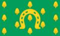
The flag of Rutland
-
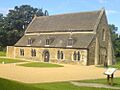
Oakham Castle
-
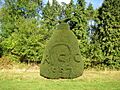
Topiary with date at Clipsham Yew Tree Avenue, marking Rutland's re-establishment in 1997
-

Rutland Water
-
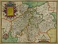
Hand-drawn map of Northampshire, Bedfordshire, Cambridgeshire and Rutland by Christopher Saxton from 1576
See also
 In Spanish: Rutland para niños
