
Corby facts for kids
Quick facts for kids Corby |
|
|---|---|
 Corby town centre in 2009 |
|

Corby
|
|
| Area | 19.5125 km2 (7.5338 sq mi) |
| Population | 68,164 (2021) |
| • Density | 3,493/km2 (9,050/sq mi) |
| OS grid reference | SP882885 |
| Civil parish |
|
| Unitary authority |
|
| Ceremonial county | |
| Region | |
| Country | England |
| Sovereign state | United Kingdom |
| Post town | CORBY |
| Postcode district | NN17, NN18 |
| Dialling code | 01536 |
| Police | Northamptonshire |
| Fire | Northamptonshire |
| Ambulance | East Midlands |
| EU Parliament | East Midlands |
| Website | Corby Town Council |
Corby is a town and civil parish in Northamptonshire, England. It is about 23 miles (37 km) north-east of Northampton. In 2021, Corby had a population of 68,164 people.
Corby was once known as "Little Scotland." This was because many Scottish workers moved there for jobs in the steelworks. The town has been updated with new buildings and facilities. These include the Corby railway station and Corby International Pool, which opened in 2009. The Corby Cube opened in 2010. It has a 450-seat theatre, a public library, and other community spaces.

Contents
Corby's Past
Early Days
People have lived in the Corby area for a very long time. Tools and items from the Mesolithic and Neolithic periods have been found. Human remains from the Bronze Age were discovered in 1970. The first permanent settlement appeared around the 8th century. Danish invaders arrived and named the place "Kori's by," meaning Kori's settlement.
The town was recorded as "Corbei" in the Domesday Book of 1086. Corby's symbol, the raven, comes from another meaning of this old word. The Danish roots are remembered in the name of a housing area called Danesholme.
In 1226, King Henry III gave Corby the right to hold two yearly fairs and a market. Later, in 1568, Queen Elizabeth I gave Corby a special charter. This charter meant local landowners did not have to pay tolls (fees for using roads) or dues (an early form of tax). It also gave all men the right to refuse to serve in the local army. A popular story says the Queen granted this charter after villagers rescued her while she was hunting in Rockingham Forest.
The Corby Pole Fair is a special event held every 20 years since 1862. It celebrates this old charter. The next Pole Fair is planned for 2022.
From Village to Industrial Town
People have been digging for iron ore in the Corby area since Roman times. In the 1800s, an ironstone industry grew when railways arrived. Large amounts of ironstone were discovered. By 1910, an ironstone works was built.
In 1931, Corby was a small village with about 1,500 people. It quickly grew into a large industrial town. This happened when Stewarts & Lloyds, the company that owned the ironstone works, decided to build a huge steelworks there. Construction began in 1934. This brought many workers from all over the country, especially from Scotland and Ireland. The first steel was made in October 1935. For many years, the steelworks was the most important part of the town. By 1939, the population had grown to about 12,000. At this time, Corby became an urban district, no longer just a village.
War and Growth
During the Second World War, the Corby steelworks was expected to be attacked by German bombers. However, only a few bombs were dropped, and no one was hurt. This might be because the area was hidden by thick, dark clouds. These clouds were made by burning oil and latex to hide the bright glow of the steel furnaces. The steelworks helped the war effort by making steel tubes. These tubes were used in Operation Pluto to supply fuel to Allied forces in Europe.
In 1950, Corby had 18,000 people. It was named a New Town. William Holford designed the town to be car-friendly, with lots of open spaces and woodlands. In the 1950s, Corby grew even more, with many people moving from Scotland.
Steel Industry Changes
In 1967, the British steel industry became owned by the government. The Corby steelworks became part of British Steel Corporation. In 1975, the government decided to stop making steel in Corby. By the end of 1981, over 5,000 jobs were lost at British Steel in Corby. More job cuts followed, leading to 11,000 jobs lost in total. This meant that over 30% of people were unemployed. However, steel tube making continued, using steel brought in from other places.
The song "Steeltown" by Big Country is about the job losses in Corby.
New Beginnings
After the steel industry declined, new businesses came to Corby. The government made it an "Enterprise Zone," which helped attract companies. By 1991, unemployment was back to the national average. Corby's recovery was helped by its central location and grants from the European Union.
North of Corby, there is a large industrial estate. It includes a 350MW power station built in 1994. The Rockingham Motor Speedway was built in 2001.
Becoming a City?
In 2012, Corby tried to become a city. This was part of Queen Elizabeth II's Diamond Jubilee celebrations. However, Corby did not get city status.
Community and Culture
Corby has a unique population because of the many Scottish people who moved there. The link with Scotland is very strong. In 2001, about 18.9% of Corby's population was born in Scotland. It is thought that another third of the population are Scottish or have Scottish family.


Many people in Corby value their Scottish heritage. There are Scottish social clubs and sports clubs. Many people support the Rangers and Celtic football clubs. Shops sell Scottish foods, and a supermarket even had Gaelic signs for a while. An annual Highland Gathering is held in the town. It features traditional Scottish sports, music, and dancing.
A local story says that Corby sells more of the Scottish soft drink Irn-Bru than any other place outside Scotland. One supermarket in Corby reportedly sells 17 times more Irn-Bru than any other store in England.
In November 2010, the Corby Cube opened in the town centre. It has a new council chamber, a registrar office, and a public library. The Cube also has a 450-seat theatre and a smaller studio theatre. It hosts live shows, music, and comedy. The theatre also shows films twice a week.
A crater on Mars was named after Corby. This happened because of a funny conversation during the Apollo 11 mission in 1969. The astronauts were told that a man in Corby won a porridge eating contest.
Local Media
Local news and TV shows for Corby are provided by BBC East and ITV Anglia. Radio stations include BBC Radio Northampton, Heart East, Smooth East Midlands, and Corby Radio. Corby’s local newspaper is the Northamptonshire Evening Telegraph.
Sports and Fun
Corby is home to Adrenaline Alley, one of Europe's largest urban sports venues. Members of Team GB have trained there for the Olympic Games.
Corby Town F.C. (football club) plays its home games at Steel Park. They are known as "The Steelmen." The club also has women’s, youth, and walking football teams.
Other sports clubs in Corby are named after the original owners of the town’s former steelworks, Stewarts & Lloyds. These include football, rugby union, cricket, and bowls clubs.
Corby also has the Corby East Midlands International Swimming Pool. It opened in 2009 and is home to the town's swimming club. Corby Athletic Club is based at the Rockingham Triangle Stadium. The town also has a Tennis Centre and clubs for Table Tennis and various combat sports. A parkrun (a free, weekly 5k run) is held at West Glebe Park.
Getting Around
Roads
Corby is located near the A43, A427, and A6003 roads. It is about 6 miles (10 km) from the A14 at Kettering. Corby is within a two-hour drive of four international airports. Because it is a new town, Corby's roads are different from older towns. It has several dual carriageways (roads with two lanes in each direction). Most main roads have wide areas next to them and high speed limits. Pedestrians often use underpasses to cross these roads.
Buses

Corby has six bus routes under the Corby Star name. Route X4 connects the town with Peterborough, Kettering, Northampton, and other places. National Express also provides long-distance bus services to the north and Scotland.
Trains

For many years, Corby did not have a railway station. A new station opened on February 23, 2009. East Midlands Railway runs trains every half hour to London St Pancras. These trains go through Kettering and Wellingborough. The route to London became electric in May 2021. There is also a limited service during busy times that goes north to Oakham and Derby.
Jobs and Learning
Jobs

Since the 1980s, the number of unemployed people in Corby has returned to the national average. Many jobs in Corby are in manufacturing. This is higher than the average for the region. Most industries are located in special industrial estates on the edge of town. Companies like Fairline Boats and Weetabix Limited (who make Weetos) have operated here. RS Components is also based near Rockingham Speedway.
Schools

The Corby campus of Tresham Institute of Further and Higher Education offers courses for students aged 16 and older, and for adults. The closest universities are in Northampton and Leicester.
Brooke Weston Academy opened in 1990. It has consistently achieved high exam results. It became a City Academy in 2008.

Corby has five secondary schools: Brooke Weston Academy, Lodge Park Academy, Corby Business Academy, Kingswood Secondary Academy, and Corby Technical School. Corby Business Academy has a special unit for children with severe special educational needs. All four schools have sixth forms for students aged 16 and over.
Corby also has 17 primary schools. Some are Church of England schools, and some are Roman Catholic schools.
Town Improvements
Corby is undergoing a lot of improvements. The North Northants Development Company is working with the local council to update the town centre. The population of Corby is expected to double in the next 30 years. New housing areas are being built, such as Prior's Hall and Oakley Vale.
In October 2007, Corby's new shopping area, Willow Place, opened. The Corby East Midlands International Pool opened in July 2009.
"The Saxon Crown" is a pub and hotel in Corby town centre. It used to be a Cooperative store. Its name refers to Corby's history, as the town's name comes from Kori, a Danish leader.
Toxic Waste Case
In July 2009, Corby Borough Council was found responsible for exposing pregnant women to toxic waste. This happened during the cleanup of the old British Steel Corporation steelworks. The exposure caused birth defects in their children. This was an important ruling because it was the first time a court found that air pollution could cause such birth defects.
Corby's Location
 |
Leicester, Melton Mowbray, Nottingham | Oakham, Grantham | Stamford, Spalding | |
| Market Harborough, Rugby, Coventry | Oundle, Peterborough | |||
| Northampton, Oxford | Kettering, Wellingborough, Milton Keynes, Bedford | Huntingdon, St Neots, Cambridge |
Weather in Corby
Like the rest of the British Isles, Corby has a maritime climate. This means it has cool summers and mild winters. The nearest weather station that kept records was in Caldecott, about 3 miles (5 km) north-northwest of Corby.
The lowest temperature ever recorded there was -23.3°C (-9.9°F) in January 1987. The highest temperature was 35.0°C (95.0°F) in August 1990.
| Climate data for Caldecott 1961–1990 (Weather station 3 miles (5 km) to the North of Corby) | |||||||||||||
|---|---|---|---|---|---|---|---|---|---|---|---|---|---|
| Month | Jan | Feb | Mar | Apr | May | Jun | Jul | Aug | Sep | Oct | Nov | Dec | Year |
| Mean daily maximum °C (°F) | 6.1 (43.0) |
6.5 (43.7) |
9.4 (48.9) |
12.2 (54.0) |
16.0 (60.8) |
19.2 (66.6) |
21.2 (70.2) |
20.9 (69.6) |
18.4 (65.1) |
14.4 (57.9) |
9.4 (48.9) |
7.0 (44.6) |
13.3 (55.9) |
| Mean daily minimum °C (°F) | 0.1 (32.2) |
0.1 (32.2) |
1.3 (34.3) |
2.9 (37.2) |
5.6 (42.1) |
8.5 (47.3) |
10.4 (50.7) |
10.3 (50.5) |
8.4 (47.1) |
5.8 (42.4) |
2.5 (36.5) |
0.8 (33.4) |
4.7 (40.5) |
| Average precipitation mm (inches) | 52 (2.0) |
40 (1.6) |
48 (1.9) |
48 (1.9) |
47 (1.9) |
48 (1.9) |
45 (1.8) |
58 (2.3) |
46 (1.8) |
46 (1.8) |
52 (2.0) |
56 (2.2) |
586 (23.1) |
| Mean monthly sunshine hours | 46.2 | 58.0 | 97.5 | 126.6 | 174.2 | 180.6 | 175.7 | 168.0 | 129.8 | 96.4 | 59.5 | 41.1 | 1,353.6 |
| Source: Met Office | |||||||||||||
Twin Towns
Corby is connected with other towns around the world. These are called twin towns:
- Châtellerault, France
- Velbert, Germany
- Shijiazhuang, China
Arms
|
Images for kids
-
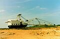
The Sundew dragline excavator was a local landmark
-
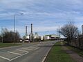
Corby's CCGT power station
-
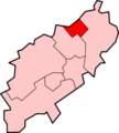
Map of the former Borough of Corby


See also
 In Spanish: Corby para niños
