
Northampton facts for kids
Quick facts for kids Northampton |
|
|---|---|
| Town and civil parish | |
|
Clockwise from top: Northampton Guildhall; All Saints' Church; Market Square; Abington Park and; the National Lift Tower |
|

Northampton
|
|
| Population | 249,093 (2021 census) |
| Civil parish |
|
| Unitary authority |
|
| Ceremonial county | |
| Region | |
| Country | England |
| Sovereign state | United Kingdom |
| Post town | NORTHAMPTON |
| Postcode district | NN1—NN7 |
| Dialling code | 01604 |
| Police | Northamptonshire |
| Fire | Northamptonshire |
| Ambulance | East Midlands |
| EU Parliament | East Midlands |
| UK Parliament |
|

.jpg)


Northampton (![]() i/nɔːrˈθæmptən/) is a large town and civil parish in Northamptonshire, England. It is the main town of Northamptonshire and the administrative centre for West Northamptonshire. The town sits on the River Nene, about 60 miles (97 km) north-west of London. It is also about 50 miles (80 km) south-east of Birmingham. Northampton is one of England's biggest towns. In 2021, its urban area had a population of 249,093 people.
i/nɔːrˈθæmptən/) is a large town and civil parish in Northamptonshire, England. It is the main town of Northamptonshire and the administrative centre for West Northamptonshire. The town sits on the River Nene, about 60 miles (97 km) north-west of London. It is also about 50 miles (80 km) south-east of Birmingham. Northampton is one of England's biggest towns. In 2021, its urban area had a population of 249,093 people.
People have lived in the Northampton area since the Bronze Age. Later, Romans and Anglo-Saxons settled here. In the Middle Ages, Northampton became very important. It had Northampton Castle, where kings sometimes lived and where the Parliament of England often met. Medieval Northampton also had many churches, monasteries, and even a university. The town was surrounded by walls.
King Richard I gave Northampton its first town charter in 1189. This allowed the townspeople more control over their own affairs. In 1215, King John appointed the town's first mayor. Northampton was also the site of two medieval battles, in 1264 and 1460.
During the English Civil War, Northampton mostly supported the Parliamentarians (known as Roundheads). Because of this, King Charles II ordered the town's walls and most of its castle to be destroyed. In 1675, the Great Fire of Northampton also ruined much of the old town. However, Northampton was quickly rebuilt. It grew fast in the 1700s with new industries. The town continued to expand in the 1800s when the Grand Union Canal and railways arrived. It became a major centre for making shoes and leather goods.
After the World Wars, growth slowed down. But in 1968, Northampton was named a New Town. This led to a lot of new building and development, which continues today. Northampton has tried four times to become a city (in 1992, 2000, 2002, and 2022), but it is still a town.
Contents
- Exploring Northampton's Past: A Journey Through Time
- Northampton's Location and Surroundings
- Who Lives in Northampton? Understanding the Population
- Northampton's Economy and Shopping
- Culture and Entertainment in Northampton
- Famous Buildings and Landmarks in Northampton
- Getting Around Northampton: Transport Links
- Learning in Northampton: Schools and University
- Notable People from Northampton
- Northampton's Twin Towns
- Freedom of the Borough
- Images for kids
- See also
Exploring Northampton's Past: A Journey Through Time
How Did Northampton Get Its Name?
The first time Northampton was written down was in 914. It was called Ham tune. The word "North" was added later to tell it apart from other towns named Hampton, like Southampton. In the Domesday Book (1086), the town was called Northantone. This name slowly changed to Norhamptone by the 1200s, and then to Northampton by the 1600s.
Early Settlements: From Bronze Age to Anglo-Saxons

Northampton has been a place where people lived for a very long time. The earliest signs of settlement are from the Bronze Age. In the Briar Hill area, archaeologists found evidence of a Neolithic camp. This camp had a large circular earthwork where farmers gathered for ceremonies around 3500 BC to 2000 BC.
During the British Iron Age, people often lived in protected hill forts. Hunsbury Hill is an example of this. It has a circular ditch and a bank with a timber wall, covering about 160 acres (65 hectares). This dates back to around 400 BC. In the Roman period, a small farming settlement likely existed in the Duston area. Pieces of Roman pottery have been found there.
After a Danish invasion, the centre of the town became a stronghold called a burh. The Anglo-Saxons probably built it. By 878, the Danes controlled this stronghold. It became a base for one of the Danish armies. A ditch was dug around the settlement, and it was protected by earth ramparts. The Danes made it a military and administrative centre as part of the Danelaw. However, the Danish army of Northampton surrendered to Edward the Elder, the Saxon King of Wessex, in 921.
In the 800s, a saint named Regenhere of Northampton was buried here. By 918, Northampton had an earl and an army. Their territory reached the River Welland. Edward the Elder made Northampton the centre of one of the new shires. The town grew as a river port and trading centre. In 940, it successfully defended itself against invading Danish forces from Northumbria. But it was burned down in 1010 by a Danish army. It was burned again in 1065 by rebellious northern earls. Despite this, the Domesday Book recorded Northantone with 316 houses and about 2,000 people. This made it a similar size to Warwick and Leicester.
Medieval Northampton: Castles, Kings, and Conflicts

After the Norman Conquest in 1066, Northampton became very important. Its central location in England made it a key spot for government. It was also a good meeting place for political, social, religious, and military events.
Northampton Castle was likely built by Simon de Senlis around 1084. He was the first Earl of Northampton. It started as an earth and timber fort, then was rebuilt in stone. The castle became a royal home from King Henry I's time until King Richard II. King John often stayed there. He even moved the Treasury to the castle in 1205.
Many Parliaments (32 in total) were held at the castle. The last one was in 1380. Important events at the castle included the trial of Thomas Becket in 1164. Also, the Treaty of Edinburgh–Northampton (peace with Scotland) was declared there. Royal tournaments and feasts also took place at the castle.
Simon de Senlis is also thought to have built the medieval town walls. These walls surrounded about 245 acres (99 hectares) and had four main gates. The circular shape of the main roads around the town centre still shows where these walls once stood. De Senlis founded the Cluniac Priory of St Andrew's. He also built The Church of the Holy Sepulchre, which is one of only four remaining round churches in England. His son, Simon II de Senlis, built St Peter's Church. He also founded Delapré Abbey, another Cluniac priory, which is still standing.
Northampton was first controlled by officials working for the King. They collected taxes and enforced laws. This changed on November 18, 1189, when King Richard I gave the town its first charter. This was in exchange for money to pay for his crusades. The charter gave the townspeople more rights and independence. In 1215, King John allowed William Tilly to be the town's first Mayor. He also ordered "twelve of the better and more discreet" residents to join him as a council. This shows how important Northampton was, as only London, York, and King's Lynn had mayors at that time.
In 1261, the medieval University of Northampton was started by King Henry III. If it had continued, it would be the third oldest university in England. However, students from the university supported Simon de Montfort, who was rebelling against the King. Also, advisors told Henry III that Northampton was a threat to Oxford's learning. So, Henry III closed the university in 1265.
Markets and fairs were very important for the town's economy. The Market Square became prominent in 1235. King Henry III ordered that goods should be sold there instead of in the churchyard of All Saints. Street names like Corn Hill and Gold Street show the types of trades that happened there. Cloth and wool were important industries, but they later declined.
In 1277, some Jewish residents were executed, and the rest were forced out of town. Archaeological sites include a medieval Jewish cemetery.
The First Barons' War caused a lot of damage to Northampton. Royal forces destroyed much of the town. The Second Barons' War also broke out. The First Battle of Northampton happened in 1264. King Henry III attacked the town, looted it, and took prisoners.
In 1349, the Black Death killed more than half of Northampton's population. By 1377, the population was only 2,200. The town was losing its wealth and importance. In 1460, the Second Battle of Northampton took place during the War of the Roses. The Yorkists won, and King Henry VI was captured. By 1484, the Mayor said Northampton was "in great desolation and ruin." The Dissolution of the Monasteries in 1538 caused even more destruction. The Plague also severely affected Northampton in 1638, killing 665 people.
From Civil War to Industrial Growth

By the time of the English Civil War, Northampton strongly supported Parliament. Even though the Earl of Northampton supported King Charles I, the townspeople backed Oliver Cromwell's Roundhead army. Northampton had a history of religious disagreement, and Puritanism was strong there. The town council refused to send troops to the King in 1632 and would not pay the unpopular ship money tax in 1636.
When the war started in 1642, Northampton became the main Parliamentarian garrison for the south-east Midlands. The old royal castle was its headquarters. In 1643, Prince Rupert attacked Northampton but was pushed back. Oliver Cromwell visited in 1645. General Fairfax marched from the town to Naseby, where King Charles I's army was defeated.
During the Civil War, Northampton made over 4,000 pairs of leather shoes and 600 pairs of cavalry boots for the Parliamentarian armies. Another 2,000 pairs were made for Cromwell's New Model Army in 1648. The shoe industry boomed in and around the town for a long time after this.
The war ended with Parliament winning. England became a Commonwealth for ten years. After King Charles II returned to power in 1660, he punished Northampton. He ordered the town's walls to be destroyed and part of its castle to be pulled down in 1662. The castle was then used as a court and jail, but it fell into disrepair.

The town centre was largely destroyed by the Great Fire of Northampton in 1675. Sparks from an open fire in a thatched cottage caused it. Strong winds spread the fire eastwards, burning three-quarters of the town centre in 24 hours. Most buildings were made of wood and thatch, which made things worse. About 600 buildings were destroyed. Only stone buildings like the Welsh House (built 1595) and Hazelrigg House (built 1662) survived.
After the fire, an Act of Parliament was passed to rebuild the town. Local people and businesses raised about £25,000. The town centre was rebuilt around the Market Square. Streets were made wider, and new buildings were made of brick and stone with tiled roofs to prevent future fires. King Charles II even donated timber from royal forests to help. In 1678, the Sessions House and County Hall were among the first buildings finished. A Georgian town with new houses, shops, and workshops grew from the ashes. In 1742, Edward Cave opened Marvel's Mill, the world's first cotton mill powered by a water wheel, on the River Nene.
A military base, Gibraltar Barracks, was built in 1797. By the end of the 1700s, Northampton was a major centre for making shoes and leather goods. In 1801, the population was 7,020. It more than doubled to 15,351 by 1831. This was because the Napoleonic Wars created a huge demand for footwear. At that time, one-third of adult men in Northampton were shoemakers. The town grew beyond its old walls, and factories became more common in the mid-1800s.

The River Nene was made navigable up to Northampton in 1762. This allowed cheap transport of coal and other goods. In 1815, the Grand Union Canal reached the town, connecting it to the River Nene. This gave Northampton a direct link to coalfields and major cities like Birmingham, Manchester, and London.
The first railway line to Northampton opened in 1845. It was a branch from the main London and Birmingham Railway. The town's first station, Bridge Street station, opened then. Later, Castle station opened in 1859 on part of the old Northampton Castle site. Castle station was rebuilt and expanded in 1880, and the castle's remains were removed for a goods shed. Today, only Castle station (now called Northampton railway station) serves the town.
Tram lines were laid in 1881 and electrified in 1903. An early bus service ran to Wellingborough. From 1919, motor buses connected the town to nearby villages, bringing more people to the market.
Iron ore quarries existed around the town in the 1800s and 1900s. Some were within the current town area, from Kingsthorpe to Hardingstone. Remains of these quarries can still be seen at Hunsbury Hill. An ironworks operated by the river, using ore from these quarries, until 1921.
Northampton Today: Growth and Modern Life

After World War I, the shoe industry declined, even though the town's factories supplied millions of boots to the armed forces. The town expanded in the 1920s. Northampton Power Station was built, supplying electricity to areas as far away as Wolverton. Many council houses were built, especially to the east, north, and south of the town. These areas, like Abington and Far Cotton, became part of the borough in 1901. However, population growth slowed as people moved outside the town's boundaries.
After World War II, Northampton changed a lot. The M1 motorway opened in 1959, and in 1968, Northampton was named a New Town. These events, along with the rail link, helped Northampton grow as a place where people live and travel to work in London. The Northampton Development Corporation (NDC) was set up in 1968. It spent £205 million to build new homes and industrial areas. These were mainly for new residents from the London area.
Older buildings in the town centre were pulled down or redeveloped. This included the former Greyfriars bus station and the Grosvenor Centre. Although growth was slower than planned, the population grew from 105,421 in 1961 to 157,217 by 1981. Over 15,000 new homes were added between 1970 and 1985.
Northampton tried to become a city in 2000, 2002, and 2022, but it is still a town. Since 2006, Northampton has been a government expansion zone. This has led to many new projects. Some completed projects include the Radlands Plaza Skatepark and Becket's Park Marina. The Market Square has been improved, and a new bus station (North Gate) and railway station have been built. A Cultural Quarter has been created, and Delapré Abbey has been restored. Northampton Museum has expanded, and the university moved to a new campus in the town centre. In 2015, St Giles Street was named the "Best British High Street."
Northampton's Location and Surroundings
Northampton is in the East Midlands region of England. It is also considered part of the South Midlands "growth area" by the government. The town is about 30 miles (48 km) south-southeast of Leicester. It is 16 miles (26 km) north-northwest of Milton Keynes. Other nearby cities include Cambridge (43 miles / 69 km east) and Oxford (37 miles / 60 km northeast).
What Are Northampton's Main Areas?

Northampton is divided into many smaller areas. These include suburbs, council wards, and other less formal areas.
Some of the suburbs and districts are:
- Abington Vale
- Abington
- Billing
- Brackmills
- Collingtree
- Cotton End
- Cultural Quarter
- Dallington
- Duston
- East Hunsbury
- Far Cotton
- Grange Park
- Great Houghton
- Hardingstone
- Hunsbury Meadows
- Kingsthorpe
- Round Spinney
- Sixfields
- St. James End
- Upton
- West Hunsbury
- Weston Favell
- Wootton
In 2021, the urban area of Northampton was divided into three new parish councils. These are the Northampton Town Council, Kingsthorpe, and Far Cotton and Delapré. There are also nine older parish councils around Northampton.
Other nearby settlements that are considered part of the Northampton urban area include Boughton, Ecton, Moulton, Overstone, and Rothersthorpe.
Where is Northampton in Relation to Other Towns?
Northampton's closest towns are Wellingborough, Daventry, and Towcester. The nearest cities are Milton Keynes, Leicester, Coventry, and Peterborough.
 |
Birmingham, Coventry, Rugby | Nottingham Loughborough Leicester Market Harborough, |
Kettering, Corby, Peterborough | |
| Worcester, Stratford-upon-Avon, Warwick, Daventry, Long Buckby | Earls Barton, Wellingborough, Rushden Cambridge |
|||
| Towcester, Brackley, Banbury Oxford |
Aylesbury | Milton Keynes, Bedford, Dunstable, Luton, London |
What is Northampton's Climate Like?
Northampton has an oceanic climate, like the rest of the British Isles. This means it has cool summers and mild winters. The official weather station is at Moulton Park, part of the University of Northampton. It is higher up than the town centre, so temperatures might be slightly different. The highest temperature ever recorded was 40.2°C (104.4°F) in July 2022. The lowest was -16.8°C (1.8°F) in February 1986.
Rainfall is around 650 mm (26 inches) per year. It can be unpredictable, sometimes causing floods like in 1998, and sometimes leading to short droughts.
| Climate data for Northampton (Moulton Park), elevation: 127 m (417 ft), 1991–2020 normals, extremes 1976–present | |||||||||||||
|---|---|---|---|---|---|---|---|---|---|---|---|---|---|
| Month | Jan | Feb | Mar | Apr | May | Jun | Jul | Aug | Sep | Oct | Nov | Dec | Year |
| Record high °C (°F) | 14.9 (58.8) |
17.9 (64.2) |
22.6 (72.7) |
26.5 (79.7) |
28.0 (82.4) |
32.1 (89.8) |
40.2 (104.4) |
34.7 (94.5) |
30.3 (86.5) |
27.9 (82.2) |
17.5 (63.5) |
15.4 (59.7) |
40.2 (104.4) |
| Mean daily maximum °C (°F) | 7.1 (44.8) |
7.8 (46.0) |
10.4 (50.7) |
13.5 (56.3) |
16.6 (61.9) |
19.6 (67.3) |
22.1 (71.8) |
21.7 (71.1) |
18.7 (65.7) |
14.4 (57.9) |
10.1 (50.2) |
7.4 (45.3) |
14.1 (57.4) |
| Daily mean °C (°F) | 4.3 (39.7) |
4.7 (40.5) |
6.6 (43.9) |
8.6 (47.5) |
12.0 (53.6) |
14.9 (58.8) |
17.2 (63.0) |
16.9 (62.4) |
14.4 (57.9) |
10.9 (51.6) |
7.1 (44.8) |
4.7 (40.5) |
10.3 (50.5) |
| Mean daily minimum °C (°F) | 1.6 (34.9) |
1.6 (34.9) |
2.9 (37.2) |
4.7 (40.5) |
7.3 (45.1) |
10.2 (50.4) |
12.3 (54.1) |
12.2 (54.0) |
10.1 (50.2) |
7.4 (45.3) |
4.2 (39.6) |
2.0 (35.6) |
6.4 (43.5) |
| Record low °C (°F) | −16.4 (2.5) |
−16.8 (1.8) |
−7.3 (18.9) |
−5.8 (21.6) |
−1.8 (28.8) |
1.0 (33.8) |
4.4 (39.9) |
4.0 (39.2) |
1.8 (35.2) |
−3.9 (25.0) |
−6.7 (19.9) |
−12.2 (10.0) |
−16.8 (1.8) |
| Average precipitation mm (inches) | 56.2 (2.21) |
44.6 (1.76) |
40.4 (1.59) |
46.9 (1.85) |
53.6 (2.11) |
52.2 (2.06) |
51.7 (2.04) |
59.6 (2.35) |
55.7 (2.19) |
66.7 (2.63) |
61.6 (2.43) |
60.1 (2.37) |
649.2 (25.56) |
| Average precipitation days (≥ 1.0 mm) | 11.9 | 9.9 | 8.4 | 9.5 | 9.2 | 9.2 | 8.6 | 9.0 | 8.9 | 10.4 | 11.5 | 11.4 | 118.0 |
| Mean monthly sunshine hours | 55.3 | 80.5 | 115.6 | 157.5 | 197.0 | 175.0 | 198.3 | 181.0 | 135.9 | 106.2 | 64.3 | 53.6 | 1,520 |
| Source 1: Met Office | |||||||||||||
| Source 2: Starlings Roost Weather Pitsford Weather Centre | |||||||||||||
Who Lives in Northampton? Understanding the Population
_population_pyramid.svg)
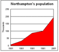
Northampton's population has grown steadily over the years. In 1801, there were 7,020 people. By 2021, the population had reached 238,654. The average age in 2011 was 37.1 years, which is younger than the English average.
In 2011, there were 91,484 homes. Most (88,731) were occupied. About 30.5% of homes were for one person. Families lived in 61.1% of homes. Many homes were owned (outright or with a mortgage) or rented.
About 75.6% of homes had at least one car or van. In terms of education, 22.5% of adults over 16 had no formal qualifications. However, 15.8% had at least 5 GCSEs at grade C or higher. The average income in 2012 was £21,193.
Between 2001 and 2011, the biggest increase in population was in the "White, Other" group. This was likely due to people moving from Eastern Europe. The "Black, African" group also grew a lot. The "White, British" group saw a decrease in numbers.
What About Northampton's Diverse Backgrounds?
In the 2011 census, Northampton's population was 84.5% White, 6.5% Asian, 5.1% Black, and 3.2% Mixed/multiple.
| Ethnic Group | Year (local authority boundaries) | |||||||||
|---|---|---|---|---|---|---|---|---|---|---|
| 1981 estimations | 1991 | 2001 | 2011 | 2021 | ||||||
| White: Total | 145,364 | 95.2% | 169,864 | 94.1% | 178,117 | 91.6% | 179,238 | 84.5% | 188,900 | 79.2% |
| White: British | – | – | – | – | 170,499 | 87.7% | 162,353 | 76.6% | 152,516 | 63.9% |
| White: Irish | – | – | – | – | 3,838 | 2% | 2,911 | 1.4% | 2,460 | 1.0% |
| White: Gypsy or Irish Traveller | – | – | – | – | – | – | 149 | 257 | 0.1% | |
| White: Roma | – | – | – | – | – | – | – | – | 1,157 | 0.5% |
| White: Other | – | – | – | – | 3,780 | 1.9% | 13,825 | 6.5% | 32,510 | 13.6% |
| Asian or Asian British: Total | – | – | 5,600 | 3.1% | 7,643 | 3.9% | 13,751 | 6.5% | 18,741 | 7.9% |
| Asian or Asian British: Indian | – | – | 2593 | 3,333 | 5,328 | 7,859 | 3.30% | |||
| Asian or Asian British: Pakistani | – | – | 513 | 795 | 1,536 | 2,439 | 1.00% | |||
| Asian or Asian British: Bangladeshi | – | – | 1198 | 1,768 | 3,367 | 4,452 | 1.90% | |||
| Asian or Asian British: Chinese | – | – | 690 | 1,278 | 1,705 | 1,418 | 0.60% | |||
| Asian or Asian British: Other Asian | – | – | 606 | 469 | 1,815 | 2,573 | 1.10% | |||
| Black or Black British: Total | – | – | 4,098 | 2.3% | 4,643 | 2.4% | 10,741 | 5.1% | 18,447 | 7.70% |
| Black or Black British: African | – | – | 385 | 1,361 | 6,473 | 12,970 | 5.40% | |||
| Black or Black British: Caribbean | – | – | 2,701 | 2,822 | 2,946 | 3,087 | 1.30% | |||
| Black or Black British: Other Black | – | – | 1012 | 460 | 1,322 | 2,390 | 1.00% | |||
| Mixed or British Mixed: Total | – | – | – | – | 3,369 | 1.7% | 6,849 | 3.2% | 8,639 | 3.60% |
| Mixed: White and Black Caribbean | – | – | – | – | 1,693 | 3,149 | 3,508 | 1.50% | ||
| Mixed: White and Black African | – | – | – | – | 272 | 1,012 | 1,374 | 0.60% | ||
| Mixed: White and Asian | – | – | – | – | 748 | 1,286 | 1,687 | 0.70% | ||
| Mixed: Other Mixed | – | – | – | – | 656 | 1,402 | 2,070 | 0.90% | ||
| Other: Total | – | – | 1,005 | 0.6% | 686 | 0.4% | 1,490 | 0.7% | 3,924 | 1.6% |
| Other: Arab | – | – | – | – | – | – | 543 | 575 | 0.2% | |
| Other: Any other ethnic group | – | – | 1,005 | 0.6% | 686 | 0.4% | 947 | 3,349 | 1.4% | |
| Ethnic minority: Total | 7,355 | 4.8% | 10,703 | 5.9% | 16,341 | 8.4% | 32,831 | 15.5% | 49,751 | 20.8% |
| Total | 152,719 | 100% | 180,567 | 100% | 194,458 | 100% | 212,069 | 100% | 238,651 | 100% |
What Religions are Practiced in Northampton?
In terms of religion, 48.7% of residents said they were Christian. About 35.7% said they had no religion. Other religions included Muslim (5.6%), Hindu (1.9%), Sikh (0.5%), Buddhist (0.4%), and Jewish (0.1%). About 6.5% did not state their religion.
| Religion | 2001 | 2011 | 2021 | |||
|---|---|---|---|---|---|---|
| Number | % | Number | % | Number | % | |
| Holds religious beliefs | 141,432 | 72.7% | 135,433 | 63.9% | 137,892 | 57.8% |
| 132,791 | 68.3% | 119,937 | 56.6% | 116,119 | 48.7% | |
| 669 | 0.3% | 924 | 0.4% | 896 | 0.4% | |
| 2,228 | 1.1% | 3,393 | 1.6% | 4,510 | 1.9% | |
| 322 | 0.2% | 273 | 0.1% | 224 | 0.1% | |
| 4,028 | 2.1% | 8,806 | 4.2% | 13,350 | 5.6% | |
| 736 | 0.4% | 1,063 | 0.5% | 1,292 | 0.5% | |
| Other religion | 658 | 0.3% | 1,037 | 0.5% | 1,501 | 0.6% |
| (No religion and Religion not stated) | 53,026 | 27.3 | 76,636 | 36.1% | 100,774 | 42.2% |
| No religion | 37,132 | 19.1% | 62,404 | 29.4% | 85,273 | 35.7% |
| Religion not stated | 15,894 | 8.2% | 14,232 | 6.7% | 15,501 | 6.5% |
| Total population | 194,458 | 100% | 212,069 | 100% | 238,666 | 100% |
Northampton's Economy and Shopping

Northampton was once famous for making shoes and other leather goods. Today, only a few specialist shoemaking companies remain. Many old shoe factories are now offices or homes.
After World War II, engineering became a big employer. The British Timken factory, which made roller bearings, opened in 1941. It employed over 4,000 people at its busiest.
Now, Northampton's main employers are in distribution and finance. Big companies like Avon Products, Barclaycard, Nationwide Building Society, and Carlsberg have offices or factories here. The University of Northampton and St Andrew's Healthcare (a mental health charity) are also major employers. In 2014, Northampton was named "the best place in the UK to start and run a business." In 2017, the town's economic output was worth £7.31 billion.
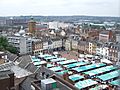
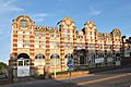
Northampton's market square is one of Britain's largest. It has been there since 1235. Abington Street is a main shopping area. There are also two indoor shopping centres: the Grosvenor Centre and Market Walk. Other shopping areas include Weston Favell Shopping Centre and Riverside Retail Park.
Culture and Entertainment in Northampton
Fun Things to Do: Leisure Activities in Northampton
Billing Aquadrome is a leisure park on the eastern edge of town. It has a caravan site, a marina, a funfair, and restaurants. Northampton Leisure Trust runs four leisure centres: Danes Camp, Lings Forum, Mounts Baths, and Duston Sports Centre. King’s Park Sports offers tennis, badminton, a climbing wall, and more. There is also a public golf course at Delapré. Radlands Plaza is a new skatepark that opened in 2012.
Northampton has 170 parks and open spaces, covering about 1,880 acres (760 hectares). Abington Park is the town's oldest park. The Racecourse was once used for horse racing and cricket. Other popular parks include Becket's Park, Bradlaugh Fields, and Delapré Park. Hunsbury Hill Park is built around an Iron Age hillfort.
Popular annual events include Northampton Carnival, the Beer Festival, the Dragonboat Race, and St Crispins Fair. The Northampton Music Festival has been held every year since 2007.
Where to Go for Entertainment in Northampton

The Royal & Derngate theatre complex is a major venue for arts and entertainment. The Deco is a 900-seat theatre and conference centre. It used to be a cinema where The Beatles performed twice in 1963. Smaller theatres include the Northampton Playhouse.
Northampton has two commercial cinemas: Vue at Sol Central and Cineworld at Sixfields. The Northampton Filmhouse is an independent cinema next to the Royal & Derngate.
There are also many local venues for live music and events. The Roadmender hosts touring bands. The town centre also has many pubs, bars, and clubs. Northampton also has ten-pin bowling alleys and casinos.
Libraries, Museums, and Art Galleries

The Northamptonshire Central Library is a Grade II listed building from 1910. There are seven other public libraries across Northampton.

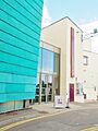
Northampton Museum and Art Gallery has one of the world's largest collections of historical footwear (13,000 items). It also has Italian art, glass, and ceramics. There is a smaller museum in the former Abington Park house. 78 Derngate is the only house in England designed by Charles Rennie Mackintosh. It is now a museum and art gallery.
The Northampton Arts Collective is located in a building called NN. The Avenue Gallery is at the University of Northampton. The university also has a Portfolio Innovation Centre for creative businesses. Other art galleries include Collective Collaborations and Primose Gallery.
Northampton's Music Scene
Several famous composers were born in Northampton, including Malcolm Arnold and William Alwyn. The Northampton Symphony Orchestra started in 1896. The gothic rock band Bauhaus formed in Northampton. The UK rapper Slowthai and pop musician SOPHIE were also born here. Dominic Major (drummer for London Grammar) and Adrian Utley (guitarist for Portishead) are also from Northampton.
Sports in Northampton

Rugby Union: The Saints and Local Clubs
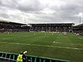
Northampton is home to the Premiership rugby union team Northampton Saints. They play at Franklin's Gardens. The Saints have won the Heineken Cup in 2000 and the English Premiership twice (2014 and 2024). They have the highest average attendance of any professional sports team in town.
Rugby Union is also very popular at an amateur level. Many secondary schools play it, and there are about 10 amateur clubs in Northampton. Northampton Outlaws is the town's first inclusive rugby team.
Football: The Cobblers
League Two The football club Northampton Town is known as "The Cobblers" because of the town's shoemaking history. They play at Sixfields Stadium. The club was founded in 1897. In 1997, they reached Wembley and won 1–0 against Swansea City. Sixfields was also briefly home to Coventry City.
There are also three non-league football clubs in the United Counties Football League: Northampton Spencer, Northampton Sileby Rangers, and Northampton Old Northamptonian Chenecks.
Cricket: The Steelbacks
Northamptonshire County Cricket Club is known as "The Steelbacks." They are one of the 18 major county clubs in English cricket. They play at the County Ground in Abington.
Motorsport: Nearby Tracks
The Silverstone Circuit, home of the British Grand Prix, is a few miles south of Northampton. Rockingham Motor Speedway and Santa Pod Raceway are also nearby. Santa Pod offers drag racing events.
Other Sports to Enjoy
Northampton also has Collingtree Park Golf Club. There are many equestrian and country activities. Water sports centres like the Nene Whitewater Centre offer whitewater courses for canoes and kayaks. The Northampton Swimming Club trained Olympic swimmer Caitlin McClatchey.
Northampton Greyhound Stadium used to host greyhound racing and speedway.
Media: News, Radio, and TV in Northampton
The Northampton Chronicle & Echo is the town's newspaper, published on Thursdays. Other free newspapers are also available. The Mercury was one of the oldest newspapers still in print, started in 1720.

Heart FM and BBC Radio Northampton are the main radio stations. There are also community radio stations like Inspiration FM, NLive Radio, Revolution Radio, and Embrace Radio.
Regional TV news is provided by BBC Look East and ITV News Anglia. Northampton has also been used for TV shows and films. William Shakespeare's play King John features Northampton Castle. The BBC sitcom Keeping Up Appearances was set in Northampton. Parts of the 2005 film Kinky Boots were filmed here. This film was later turned into a successful musical.
Famous Buildings and Landmarks in Northampton


The Church of the Holy Sepulchre is one of England's largest and best-preserved round churches. It was built around 1100, based on the original Church of the Holy Sepulchre in Jerusalem.
Northampton Castle was once one of the country's most important castles. It was a royal home and hosted Parliament many times. Thomas Becket was imprisoned there. The castle was mostly demolished in 1879 to build the railway station. Only a small part of the keep mound and a rebuilt postern gate remain.
The current All Saints' Church was built after the Great Fire of Northampton in 1675 destroyed the old church. Only the medieval tower and crypt survived. The church was rebuilt by 1680, with help from King Charles II. His statue can be seen above the church's entrance.

Other important church buildings include Northampton Cathedral, St Peter's, and St Matthew's. St Matthew's has a Henry Moore sculpture of the Madonna.
Just south of the town centre is Delapré Abbey, a former nunnery. It was founded in 1145. One of the three standing Eleanor crosses is at the edge of the Abbey. It marks where the body of Eleanor of Castile rested on its way to London.
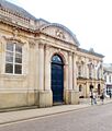
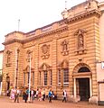
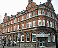
St Andrew's Hospital, opened in 1838, is a large neo-classical building. Northampton Guildhall was built in the 1860s in a Victorian Gothic style.
78 Derngate is a Georgian Town House remodeled by Charles Rennie Mackintosh. It is open to the public and is his only major domestic work outside Scotland.
The National Lift Tower is 127.45 metres (418 feet) tall and can be seen from most of the town. It was built to test new lifts. It is sometimes called the "Northampton Lighthouse" or the "Cobblers' Needle."
The former Greyfriars bus station served the town from 1976 to 2014. It was demolished in 2015 by a controlled explosion.
Memorials in Northampton
.jpg)
Northampton has several important war memorials. The Town and County War Memorial was unveiled in 1926. It remembers those from Northamptonshire who died in the First World War. It is a Grade I listed building. A second memorial in Abington Square lists the names of the town's fallen. A bust of Edgar Mobbs, a rugby player killed in the First World War, is also there.
A memorial to Nobel Prize winner Francis Crick, who was born in Northampton, was put up in 2005. The sculpture, Discovery, was created by artist Lucy Glendinning.
Getting Around Northampton: Transport Links


Northampton is served by junctions 15, 15a, and 16 of the M1 motorway. This motorway connects the town to London in the south and Leeds in the north. The A45 and A43 roads link Northampton to other towns in Northamptonshire and beyond. A partially completed ring road helps drivers get around. The A14 is also nearby, connecting to East Anglia.
Northampton railway station is on the Northampton Loop Line. Trains go south to London Euston and north to Birmingham and Crewe.
Sywell Aerodrome is the closest airfield for private flights. For international travel, East Midlands Airport and Luton Airport are easily reached by the M1 motorway. Birmingham Airport is also accessible by motorway and train.
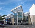
Buses in Northampton are mainly run by Stagecoach Midlands from the North Gate bus station. They serve areas within the town and connect to nearby villages and towns like Corby and Kettering. National Express also operates routes to major UK cities.
Northampton is the end point of a branch of the Grand Union Canal. This canal connects to the River Nene and then to the North Sea. It is now used for fishing and narrowboats.
Northampton once had a horse-drawn tramway that opened in 1881. It was electrified in 1904 but closed in 1934 due to competition from motor buses. Two original tram shelters are still preserved.
Learning in Northampton: Schools and University
The first University of Northampton was started by King Henry III in 1261. It began to compete with the universities in Cambridge and Oxford. However, King Henry III closed it in 1265. He was advised that it was a threat to Oxford.
The university's name was brought back in 2005. The unconnected University College Northampton, founded in 1924, became the University of Northampton. This is the only higher education (HE) place in town. It offers courses from foundation to doctoral levels. The university moved to a new £330 million waterside campus in the town centre in 2018.
Northampton's only further education (FE) college is Northampton College. It is one of the largest FE colleges in the South Midlands. It has two campuses and offers vocational courses, GCSEs, and A Levels. Moulton College is another FE college nearby. It specializes in land-based subjects, sports, and construction.
There are 50 primary schools and 8 secondary schools in Northampton. In 2001, the education system changed from three tiers to two tiers (primary and secondary). This was to improve education standards. Northampton School for Boys was the top-performing comprehensive school in the country in 2007. Northampton School for Girls was the first school in England to get Specialist Music College status. In 2015, about 55% of students in Northampton achieved five A*-C grades at GCSE. There are also 5 special schools in the town. Northampton High School is an independent school for girls.
Notable People from Northampton
Northampton's Twin Towns
Northampton is twinned with:
Freedom of the Borough
The following people, military units, and organizations have received the Freedom of the Borough of Northampton.
Individuals
- General Henry Horne, 1st Baron Horne: 1919.
- Diana, Princess of Wales: 8 June 1989.
- Sir Malcolm Arnold: 1989.
- Chantelle Cameron: 12 December 2023.
- Courtney Lawes: 12 December 2023.
Military Units
- Northampton Unit Sea Cadet Corps: 26 March 2012.
- 9th/12th Royal Lancers: 5 November 2012.
Organisations and Groups
- NHS trust Northampton: 17 June 2020.
Images for kids
-
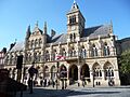
Northampton Guildhall
-
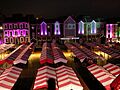
Northampton Market Square
-
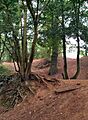
Earthworks at Hunsbury Hill
-
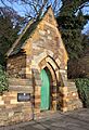
Postern Gate of Northampton Castle
-
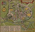
Map of Northampton by John Speed (1610)
-
Sessions House
-
Northampton Market Square
-
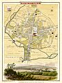
Map of Northampton in 1810
-
Northampton Population
-
Barratts Boot and Shoe factory
-
Royal & Derngate
-
Northamptonshire Central Library
-

Northampton Museum and Art Gallery
-
Franklin's Gardens
-
Radio Northampton's Broadcasting House
-
North Gate bus station

See also
 In Spanish: Northampton para niños
