West Hunsbury facts for kids
Quick facts for kids West Hunsbury(old name: Shelfleys) |
|
|---|---|
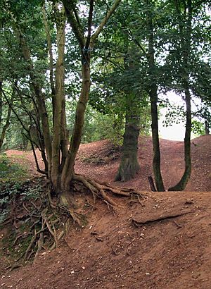
Hill Fort known as Danes Camp at Hunsbury Hill Park, West Hunsbury |
|
| Population | 4,751 (United Kingdom ONS 2013) Data for West Hunsbury ward, Northampton Borough Council"/> |
| OS grid reference | SP725585 |
| • London | 67 miles (108 km) |
| Civil parish |
|
| Unitary authority |
|
| Ceremonial county | |
| Region | |
| Country | England |
| Sovereign state | United Kingdom |
| Post town | NORTHAMPTON |
| Postcode district | NN4 |
| Dialling code | 01604 |
| Police | Northamptonshire |
| Fire | Northamptonshire |
| Ambulance | East Midlands |
| EU Parliament | East Midlands |
| UK Parliament |
|
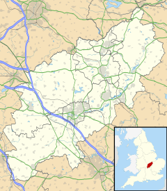
West Hunsbury is a large neighbourhood located in the south of Northampton, England. It's about 2 kilometres (1.2 miles) from the town centre. You can often hear and see the M1 motorway nearby because West Hunsbury is on higher ground.
West Hunsbury is part of a larger area called Hunsbury, which also includes East Hunsbury. An older name for the area was Shelfleys, which you might still see on some signs. For a long time, people dug for iron ore here. An ironworks, a factory that processed iron, was built in 1873. West Hunsbury grew into the neighbourhood it is today mostly during the 1970s, 1980s, 1990s, and 2000s.
The Iron Industry
The iron industry was active in West Hunsbury from the early 1870s until 1921. The Hunsbury Ironworks was built near a canal and a railway line. This factory used local iron ore, as well as ore from other parts of southern Northamptonshire.
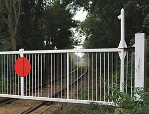
At first, the places where they dug for ore (called quarries) were right next to the factory. Later, they dug in other areas, including near Hunsbury Hill Camp. To move the heavy iron ore, they used a special narrow railway called a tramway. At first, wagons moved by gravity or by horses. Later, in 1912, they started using steam locomotives to pull the trains. Workers dug the ore by hand using picks and shovels.
The ironworks stopped making iron on January 28, 1921. The owner wanted to open it again but passed away. Later, another company bought the land in 1935, but they also didn't reopen the works.
After the quarries closed, the land was not fully tidied up. For many years, you could clearly see the quarry faces and uneven ground. However, when the houses were built from 1970 onwards, most of these old quarry signs disappeared. Today, you can only see remains of the quarrying in Hunsbury Hill Park and in East Hunsbury. To remember this history, a pub was named "The Ironstone" (now closed), and there's a street called Ironstone Lane.
How Many People Live Here?
In 2001, about 7,468 people lived in the wider West Hunsbury area. This included 3,727 males and 3,741 females, living in 3,005 homes. It's important to know that this number covers a slightly larger area than just West Hunsbury itself.
What's in West Hunsbury?
Community Places
West Hunsbury has a modern church called St Benedicts, which is part of the Church of England. There are also shops, including a small supermarket, a post office, a pharmacy, and an optician. A health centre is also located here.
At Hunsbury Hill Country Park, you can find a small cafe called "The Drover's Return." It's named after an old pathway that goes through the park.
Near the shops, there's a group of sheltered homes with a small community centre. This centre is used for social events and meetings for local residents.
West Hunsbury shares many facilities with East Hunsbury. At the junction of the old Towcester Road and Mereway ring road, you'll find a large 24-hour Tesco supermarket (except Sundays). There's also a petrol station, a Subway restaurant, an Indian restaurant, and a dry cleaner. The Danes Camp Leisure Centre has a swimming pool. Collingtree Park Golf Course is also nearby.
The Hunsbury Hill Centre is made up of old farm buildings from around 1770. It looks out over the River Nene valley. The main farmhouse is a listed building, meaning it's historically important. The centre is used by the community and has three rooms for events, plus a courtyard. It can host various gatherings, with the main hall seating up to 120 people. There's also plenty of free parking. This centre is owned by Northamptonshire ACRE, a charity that helps rural communities in Northamptonshire. Money earned from the centre helps support the charity's work.
Parks and Green Spaces
West Hunsbury is home to Hunsbury Hill Country Park, which has an Iron Age hill fort dating back to about 400 BC. This means it was a fortified settlement built on a hill a very long time ago!
The area around the park was also heavily quarried for ironstone between 1880 and 1921. A small part of the railway that used to carry the iron ore is still there for demonstrations, along with a museum. Another park is located at the bottom of the hill, separating the houses from The Counties Crematorium.
Schools
There is one primary school in West Hunsbury called Hunsbury Park Primary School. For older students, the area is in the catchment zone for Abbeyfield School. This school used to be called Mereway Upper School.
Many children also attend primary schools in nearby villages like Milton Malsor, Gayton, Rothersthorpe, Blisworth, and Collingtree. For secondary school, some students go to Campion School in Bugbrooke or Caroline Chisholm School in Wootton.
How West Hunsbury is Governed
Since April 1, 2013, West Hunsbury has had its own local council called the West Hunsbury Civil Parish Council. The first elections for this new council were held on May 2, 2013.
Before this, West Hunsbury was part of different parishes. For a while, it was part of a larger area called the West Hunsbury ward, which elected local councillors. However, this ward also included other neighbourhoods like Camp Hill and Hunsbury Meadows. In 2011, the boundaries changed, and West Hunsbury became its own borough ward, electing one councillor. The Parish Council formed in 2013 covers the same area as this borough ward.
West Hunsbury used to be part of the Northampton South area for national elections. However, since the 2010 general election, it has been part of the South Northamptonshire area, which elects a Member of Parliament (MP) to the UK Parliament.
 | Laphonza Butler |
 | Daisy Bates |
 | Elizabeth Piper Ensley |


