Kettering facts for kids
Quick facts for kids Kettering |
|
|---|---|
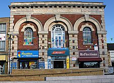
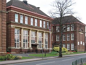
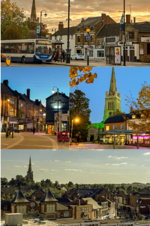 Clockwise from top: Horsemarket. Market Hill. Town Centre. Market Street |
|
| Population | 56,676 (Parish, 2021) 63,150 (Built up area, 2021) |
| OS grid reference | SP8778 |
| • London | 67 miles (108 km) |
| Civil parish |
|
| Unitary authority |
|
| Ceremonial county | |
| Region | |
| Country | England |
| Sovereign state | United Kingdom |
| Post town | KETTERING |
| Postcode district | NN14, NN15, NN16 |
| Dialling code | 01536 |
| Police | Northamptonshire |
| Fire | Northamptonshire |
| Ambulance | East Midlands |
| EU Parliament | East Midlands |
| UK Parliament |
|
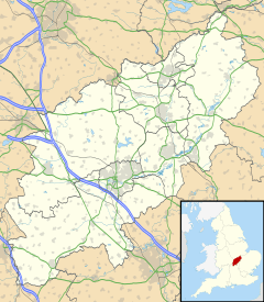
Kettering is a busy town in Northamptonshire, England. It's known for its markets and factories. The town is about 45 miles (72 km) west of Cambridge and 15 miles (24 km) north-east of Northampton. It sits west of the River Ise, which flows into the River Nene. The name "Kettering" means "the place of Ketter's people."
In 2021, Kettering had a population of 63,150 people. It's part of the East Midlands region. Many people who live here travel to work in other places, especially London. This is because Kettering is on the Midland Main Line railway, and you can get to London St Pancras International in about an hour by train.
Contents
Kettering's Early History
The name Kettering comes from old words meaning "the place of Ketter's people" or "Ketter's family." In the 10th century, it was spelled in different ways like Cytringan and Kyteringas. Words ending in "-ing" often come from the Anglo-Saxons, meaning "the people of" a certain group.
Before the Romans arrived, this area didn't seem to have many people living in it. Not many old tools or signs of early humans have been found from the Stone Age. Around 500 BC, people from Europe brought the Iron Age to the area. They built hillforts, which were like fortified villages, with the closest one to Kettering being at Irthlingborough.
Roman Times in Kettering
Around the 1st century BC, the Kettering area became part of the land of the Catuvellauni tribe. These people were conquered by the Romans in AD 43.
Kettering started as an early Roman-British settlement without walls. This old settlement is now under the northern part of the modern town. People lived here until the 4th century. There's proof that a lot of iron was melted here. This area was one of the three main places for iron-working in Roman Britain. Pottery ovens have also been found nearby.
Saxon Times in Kettering
In the early 1900s, archaeologists found a large early Saxon burial site near Kettering. It had at least a hundred cremation urns from the 5th century AD. This suggests that Anglo-Saxons might have settled here very early in England's history.
By the 7th century, the land that would become Northamptonshire was part of the Anglo-Saxon kingdom of Mercia. The Mercians became Christians in 654. Around 889, the Danes conquered the Kettering area and much of England, making it part of the Danelaw. The old road called Watling Street was the border. The English, led by Edward the Elder, son of Alfred the Great, took it back in 917. The Vikings of York conquered it again in 940 but the English took it back in 942.
It's thought that Kettering didn't exist as a village until the 10th century. Before that, it was probably just a few family farms. The first time Kettering is mentioned in history is in a document from 956. In this document, King Edwy gave land to a goldsmith named Ælfsige. It's possible that Ælfsige then gave Kettering to the Peterborough monastery.
Medieval Kettering
In 1086, the Domesday Book listed Kettering manor as belonging to the Abbey of Peterborough. The church owned a lot of land there.
Boughton House, a grand old home sometimes called the 'English Versailles', has been the home of the Dukes of Buccleuch for centuries. They owned a lot of land in Kettering and the nearby villages.
Kettering's skyline is dominated by the tall spire of the Parish church of SS Peter and Paul. The church's first known priest was in 1219. Most of the church building was rebuilt in the mid-15th century. You can still see two medieval wall paintings inside the church.
King Henry III gave permission for Kettering to have a market in 1227.
Kettering in the 17th Century
In June 1607, a small uprising called the Midland Revolt happened in the nearby village of Newton. People were protesting against local landlords who were fencing off common land. On June 8, a battle took place between the protesters, many from Kettering, and the local wealthy families. About 40-50 local men were killed, and the leaders were executed. This event was one of the last times that ordinary English people and the wealthy landowners fought openly.
By the 17th century, Kettering was an important place for making woollen cloth.
Kettering's Recent History (from 19th Century to Today)
Kettering grew a lot in the 1800s because of the boot and shoe industry. This industry made Northamptonshire famous. Many big houses were built for factory owners, and smaller terraced houses were built for the workers. However, since the 1970s, the shoe industry has shrunk a lot. Many big shoe companies have left Kettering or closed down because of competition from other countries. Only two smaller shoe businesses remain.
William Carey, who was born in 1761, lived in Kettering before he went to India as a missionary in 1793. Streets and buildings in Kettering are named after him. Andrew Fuller helped Carey start the Baptist Missionary Society, and he is remembered by the Fuller Church. In 1803, William Knibb was born in Kettering. He became a missionary and worked to free slaves. The Knibb Centre is named after him.
Politics in Kettering could be quite lively! In 1835, the writer Charles Dickens, who was a young reporter, saw a riot during an election. A supporter of one political party even pulled out a loaded pistol! This event made Dickens have some strong opinions about Kettering and its voters.
The Midland Railway opened Kettering railway station in 1857. This helped the local economy, which had been struggling because railways meant less travel on old roads. The railway line connected Kettering to Leicester and Hitchin. In 1868, Kettering got a direct train line to London St Pancras.
In 1887, a book called Gazetteer of the British Isles described Kettering. It said Kettering was an old town, called "Kateringes" by the Saxons. It had industries like tanning, shoe-making, and making brushes and farm tools. It also had a town hall, a cattle market, and a grammar school. Many Roman items had been found nearby.
Iron-ore quarrying started in the Kettering area in 1863. This was probably the first time since Roman times that iron ore was dug up here. The quarries continued until 1980. There were also two ironworks near the town that used the local ore. The Cransley Ironworks and the Kettering Ironworks both stopped making iron in 1959.
In 1921, Wicksteed Park, Britain's second-oldest theme park, opened on the edge of town.
From 1942 to 1945, many American soldiers came to Kettering. They were mainly from the US 8th Air Force based at RAF Grafton Underwood, which was about 3.7 miles (6 km) away. The first bombing raid led by Major Paul W. Tibbets, who later piloted the plane that dropped the atomic bomb on Hiroshima, took off from Grafton Underwood.
How Kettering is Governed
Kettering has two levels of local government: the Kettering Town Council and the North Northamptonshire Council. The Town Council has its offices at 10 Headlands. The North Northamptonshire Council has its main offices in Corby, but it also uses the old Kettering Borough Council headquarters on Bowling Green Road as a local office.
Kettering's Administrative History
Kettering was an old parish. Until 1872, a group called the "vestry" governed the parish. In 1872, the parish became a "local government district" run by a local board. This board met at the Town Hall, which was inside the Corn Exchange.
These local government districts became "urban districts" in 1894. In 1904, the council moved its meetings to Stamford Road School. Kettering Urban District grew in 1935 to include Barton Seagrave. In 1938, the urban district became a "municipal borough," which meant the council could have a mayor.
The council moved to the Municipal Offices on Bowling Green Road in 1966. This building used to be Kettering Grammar School.
In 1974, the municipal borough of Kettering was replaced by a larger area called the Borough of Kettering. Kettering itself no longer had its own parish council. However, Barton Seagrave became a separate parish again in 2002.
In 2021, the Borough of Kettering was replaced by the new North Northamptonshire Council. At the same time, Kettering became a civil parish again and got a new town council. This new Kettering Town Council took over the role of having a mayor from the old borough council.
Kettering's Parliament Representative
Kettering is represented in the UK Parliament by an MP (Member of Parliament) for the Kettering constituency. Currently, the MP is Philip Hollobone from the Conservative Party.
Kettering's Economy
Kettering's economy used to be all about the boot and shoe industry. When railways arrived in the 1800s, other industries like engineering and clothing also grew. For example, the clothing company Aquascutum built its first factory here in 1909. Today, Kettering's economy mainly focuses on services and distribution (moving goods around). This is because of its central location and good transport links.
Kettering has a low unemployment rate, meaning most adults have full-time jobs. Many companies are based here, including Aryzta, Weetabix, and RCI Europe. Wicksteed Park, Britain's second-oldest theme park, is also in Kettering. It attracts over a million visitors each year and has a very large free playground. The company that built the playground, Wicksteed Playscapes, is based in Kettering and is the world's oldest playground maker.
Kettering General Hospital provides emergency and general hospital services for the north of Northamptonshire. Tresham College of Further and Higher Education is also a big employer, with a new campus, 16,000 students, and 800 staff.
The old police station on London Road is now closed and for sale. The police now have an enquiry desk inside the Kettering Municipal Offices.
Kettering Business Park is a new development with many office buildings and a new hotel. Many large warehouses for distributing goods have also been built, creating thousands of jobs.
Kettering's Heritage Quarter has the Manor House Museum and the Alfred East Gallery. Nearby landmarks include the beautiful Boughton House, a Queen Eleanor cross, and the 1597 Triangular Lodge. Sir Thomas Tresham built the Triangular Lodge to show his Catholic faith after being imprisoned for it.
Town Regeneration
In March 2007, a plan was announced to improve Kettering town centre. This project included new water features, public art, sculptures, street furniture, trees, and special pavement lighting.
Education in Kettering
Kettering has many primary schools, including St Peter's School, Park Road School, St Thomas More Catholic School, and St Andrew's Church of England School. A new Church of England primary school, Hayfield Cross, opened in September 2015.
There are four secondary schools in Kettering where students can study up to A-Levels and BTEC Diplomas. These are Bishop Stopford School, Kettering Science Academy, Kettering Buccleuch Academy, and Southfield School for Girls. The Kettering Science Academy and Kettering Buccleuch Academy are linked to primary schools to help students move from Key Stage 2 to Key Stage 3.
Latimer Arts College is also nearby in Barton Seagrave. It has a sixth form for older students.
Kettering is also home to one of Tresham College of Further and Higher Education's campuses. Tresham College offers courses for students over 16, such as hairdressing, IT, and motor vehicle technology. They also offer courses that help students get into university.
Sports in Kettering
The Kettering Conference Centre is a large facility that has a leisure centre, health club, and a conference centre. It's also the home of Volleyball England's National Volleyball Centre.
Football
Kettering Town F.C. is the town's football club. As of the 2021–22 season, they play in the National League North, which is the sixth level of English football. Kettering Town used to play at Rockingham Road in the town until 2011. Now, they play their home matches at Latimer Park in Burton Latimer.
Rugby
Kettering is home to Kettering Rugby Football Club (KRFC), located on Waverley Road. The club officially started playing under RFU (Rugby Football Union) rules in 1875. In its early days, the club played on different fields before getting its own home ground.
Other Sports
A short-lived greyhound racing track opened in Kettering on July 4, 1930. Races were held on Friday evenings. It was an independent track, meaning it wasn't part of the main racing organization.
Media in Kettering
Local news and TV shows for Kettering are provided by BBC East and ITV Anglia. TV signals come from the Sandy Heath TV transmitter.
The town's local radio stations are Northants 1 and Northants 2 from NN Media. This local media group provides local information, news, and advertising. They also offer media training for young people. You can also listen to BBC Radio Northampton on 103.6 FM, Heart East on 96.6 FM, and Smooth East Midlands on 107.4 FM.
Kettering has two local newspapers: the Northamptonshire Evening Telegraph and the Northampton Chronicle and Echo.
In the BBC soap opera EastEnders, a character named Sonia Fowler moved to Kettering for a new job between 2016 and 2017. The town has been mentioned in the show several times since then.
Transport in Kettering
Roads
The A14 road goes around the west and south of Kettering. It connects the town to the A45 dual carriageway and the M1 and M6 motorways. The A6003 links Kettering to Corby. The A43 connects Kettering with Corby and Northampton. The A509 links Kettering with Wellingborough. The A6 connects Kettering with Rushden and Bedford.
Buses
In April 1986, the bus station moved from the market area to the Newland Street entrance of the Newlands shopping centre. This caused a big drop in market business. Buses were moved back to the market area in April 1987 but then closed again in September 1989. A smaller bus station also closed in May 1999. Now, all buses use the new Horsemarket bus interchange, which opened in May 2010. New bus stops have also been put near the railway station and The Headlands.
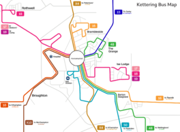
Bus services in Kettering are run by Stagecoach Midlands. Here are some of the routes:
- 15 – Kettering – Highfield Road – Stamford Road – Geddington – Corby
- 16 – Brambleside – Kettering – Cranford – Thrapston – Raunds
- 48 – Stamford Road – Kettering – Burton Latimer – Irthlingborough – Wellingborough
- 50 – Kettering – Burton Latimer – Irthlingborough – Higham Ferrers – Rushden – Bedford
- 17 – Thrapston – Ise Lodge – Kettering – Telford Way – Rothwell – Desborough
- 18 - Ise Lodge – Kettering – Telford Way – Rothwell – Desborough – Market Harborough
- 19 – Ise Lodge – Kettering – Rothwell – Desborough – Rushton – Corby
- X4 – Peterborough – Oundle – Corby – Kettering – Wellingborough – Northampton
- X10 – Kettering – Broughton – Moulton – Northampton
- 10 – Kettering – Mawsley – Moulton – Northampton
Rail
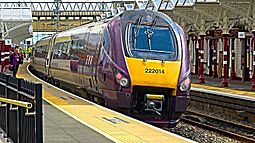
East Midlands Railway runs train services from Kettering to London St Pancras. Trains leave every 30 minutes, and the journey takes about 59 minutes. These trains stop at Wellingborough, Bedford, and Luton. Faster, direct trains also leave every 30 minutes and take about 41 minutes. From St Pancras, you can connect to the Eurostar service to France and Belgium. Kettering also has direct trains to Corby, Leicester, and Nottingham. You can reach Derby and Sheffield by changing trains at Leicester. Because of these good train links, many people who live in Kettering travel to work in other towns.
Air
Five airports are within a two-hour drive of Kettering: Heathrow, Luton, East Midlands, Birmingham, and Stansted. You can get to Luton directly by train. Sywell Aerodrome, about 6 miles (10 km) southwest of Kettering, is used for private planes and flight training.
Notable People
Climate in Kettering
Kettering has an oceanic climate, which means it has mild temperatures and rainfall throughout the year, similar to most of the British Isles.
| Climate data for Kettering, GBR | |||||||||||||
|---|---|---|---|---|---|---|---|---|---|---|---|---|---|
| Month | Jan | Feb | Mar | Apr | May | Jun | Jul | Aug | Sep | Oct | Nov | Dec | Year |
| Mean daily maximum °C (°F) | 7 (45) |
8 (46) |
11 (52) |
13 (55) |
17 (63) |
19 (66) |
22 (72) |
23 (73) |
19 (66) |
14 (57) |
10 (50) |
7 (45) |
14 (58) |
| Mean daily minimum °C (°F) | 2 (36) |
2 (36) |
4 (39) |
4 (39) |
7 (45) |
10 (50) |
12 (54) |
12 (54) |
10 (50) |
8 (46) |
5 (41) |
3 (37) |
7 (44) |
| Average precipitation cm (inches) | 4.51 (1.78) |
3.39 (1.33) |
2.87 (1.13) |
4.39 (1.73) |
3.49 (1.37) |
4.66 (1.83) |
4.21 (1.66) |
4.69 (1.85) |
5.49 (2.16) |
5.68 (2.24) |
4.8 (1.9) |
4.98 (1.96) |
53.16 (20.94) |
Nearby Places
Kettering's closest towns are Desborough, Burton Latimer, and Rothwell. Larger towns nearby include Corby and Wellingborough.
 |
Rothwell, Desborough, Market Harborough, Leicester | Cottingham, Leicestershire villages |
Geddington, Corby |  |
| Broughton, Mawsley, Rugby | Thrapston, Huntingdon | |||
| Pytchley, Northampton | Burton Latimer, Islip, Wellingborough | Finedon, Irthlingborough, Rushden, London |
Town Twinning
Kettering has "twin town" relationships with other places around the world. This means they share cultural and educational links. Kettering is twinned with:
- Kettering, Ohio, United States
- Lahnstein, Germany
- Kettering, Tasmania, Australia
|
See also
 In Spanish: Kettering para niños
 | Frances Mary Albrier |
 | Whitney Young |
 | Muhammad Ali |


