Postal counties of the United Kingdom facts for kids
Quick facts for kids Postal county |
|
|---|---|
| Also known as: Former postal county |
|
 |
|
| Category | Postal geography |
| Location | United Kingdom |
| Created | Major revision 1974 |
| Abolished | 1996 |
| Number | 116 (as of 1996) |
| Possible types | England (48) Northern Ireland (6) Scotland (54) Wales (8) |
| Subdivisions | Post town |
The postal counties were special areas used by Royal Mail in the United Kingdom until 1996. Their main job was to help sort mail. They made sure that towns with similar names didn't get mixed up.
For example, if there were two "Springfield" towns, the postal county helped mail go to the right one. After 1996, this job was taken over by the first part of the postcode, called the "outward code".
Even though postal counties were based on the actual counties of the UK, their borders weren't always the same. Sometimes, there were big differences. These borders also changed over time as new post towns were created or old ones were updated.
Royal Mail says that postal county information is no longer needed for addresses. It was removed from their main address database in 2000. However, some companies still use this old information. This can sometimes cause confusion.
Contents
Why Postal Counties Were Different
Counties have been used in postal addresses for a very long time. But over the years, the postal counties often didn't match the real geographic counties. This happened for a few reasons:
When a Town Was in Another County's Post Area
Imagine a small village right on the edge of a county. Its mail might travel faster through a post office in the next county over. Because of this, the village's postal address would use the postal county of that nearby post town, even if the village itself was in a different geographic county.
In 1963, a government official explained this. He said that postal addresses are like "routing instructions" for mail sorters. The main goal was to deliver mail quickly and cheaply. Changing these postal boundaries to match real county lines would either slow down mail or cost too much money.
Here are some examples of places where the postal county was different from the geographic county:
| Geographic locality | Geographic county | Post town | Former postal county |
|---|---|---|---|
| Chenies | Buckinghamshire | RICKMANSWORTH | Hertfordshire |
| Chirbury | Shropshire (England) | MONTGOMERY | Powys (Wales) |
| Hinwick and Podington | Bedfordshire | WELLINGBOROUGH | Northamptonshire |
| Melbourn | Cambridgeshire | ROYSTON | Hertfordshire |
| Pitstone | Buckinghamshire | LEIGHTON BUZZARD | Bedfordshire |
| Shirebrook | Derbyshire | MANSFIELD | Nottinghamshire |
| Tatsfield | Surrey | WESTERHAM | Kent |
| Ugley and Molehill Green | Essex | BISHOP'S STORTFORD | Hertfordshire |
| Woodcote and Sonning Common | Oxfordshire | READING | Berkshire |
After local government changes in 1974, more examples appeared:
| Geographic locality | Ceremonial county | Post town | Former postal county |
|---|---|---|---|
| Birtley | Tyne and Wear | CHESTER LE STREET | County Durham |
| Coleshill and Water Orton | Warwickshire | BIRMINGHAM | West Midlands |
| Seaton Delaval | Northumberland | WHITLEY BAY | Tyne and Wear |
| Sedgefield | County Durham | STOCKTON-ON-TEES | Cleveland |
| Stokesley and Great Ayton | North Yorkshire | MIDDLESBROUGH | Cleveland |
These postal county differences could change. For example, Chinley in Derbyshire used to have "Stockport, Cheshire" as its postal address. Later, it changed to "High Peak, Derbyshire" when a new post town was created.
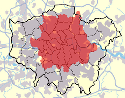
London's Special Postal Area

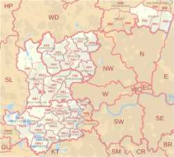
London had its own special postal area. This area didn't match any official city or county borders. It was created in 1858 and changed a few times.
If you lived in this special London postal area, your address didn't need a county name. But if you lived in other parts of Greater London, your address might still include a postal county like Surrey, Kent, Essex, Middlesex, or Hertfordshire.
For example, Wembley Stadium was in London, but its postal address was "Wembley, Middlesex." Some parts of London boroughs were even split between different postal counties.
Changes to Official County Borders
The Royal Mail sometimes adopted new county borders, but not always. In 1965, London's local government changed. The Post Office did reflect some of these changes, like Potters Bar moving from Middlesex to Hertfordshire. But other places, like Staines, still used Middlesex in their postal address, even though they had moved to Surrey.
In the 1970s, the Post Office faced challenges. They delivered to more addresses, but people sent less mail. This meant less money for the Post Office and higher costs. Keeping the old postal county borders often saved money.
In 1974, many county borders in England and Wales changed again. The Post Office decided to use most of these new counties for postal addresses. They said people should start using them by July 1, 1974. However, old county names could still be used until July 1, 1975.
Some counties, like Cumberland and Yorkshire, stopped being used as postal counties after these changes.
In Scotland, counties were officially removed for local government in 1975. But the postal counties in Scotland did not change. For example, Alva was in the Central Region, but its postal county was still Clackmannanshire. This was because postal addresses were about sorting mail, not describing geography.
Special Post Towns Without Counties
There were 110 "special post towns" where the postal county was left out of the address. These were usually large towns or cities, or places where the county name was the same as the post town.
Here are some of those special post towns:
- ABERDEEN
- ABOYNE
- ANTRIM
- ARMAGH
- AYR
- BANFF
- BATH
- BEDFORD
- BELFAST
- BERWICK-UPON-TWEED
- BIRMINGHAM
- BLACKBURN
- BLACKPOOL
- BOLTON
- BOURNEMOUTH
- BRIGHTON
- BRISTOL
- BROMLEY
- BUCKINGHAM
- BUSHEY
- CAMBRIDGE
- CARDIFF
- CARLISLE
- CHELMSFORD
- CHESTER
- CLACKMANNAN
- COLCHESTER
- COVENTRY
- CREWE
- CROYDON
- DARTFORD
- DERBY
- DUMBARTON
- DUMFRIES
- DUNDEE
- DURHAM
- EDINBURGH
- ELLESMERE PORT
- EXETER
- FALKIRK
- GLASGOW
- GLOUCESTER
- GUERNSEY
- HEREFORD
- HERTFORD
- HOUNSLOW
- HUDDERSFIELD
- HULL
- INVERNESS
- IPSWICH
- ISLE OF MAN
- ISLES OF SCILLY
- JERSEY
- KINROSS
- KIRKCUDBRIGHT
- LANARK
- LANCASTER
- LEEDS
- LEICESTER
- LINCOLN
- LIVERPOOL
- LONDON
- LONDONDERRY
- LUTON
- MANCHESTER
- MILTON KEYNES
- NAIRN
- NESTON
- NEWCASTLE UPON TYNE
- NORTHAMPTON
- NORWICH
- NOTTINGHAM
- OLDHAM
- ORKNEY
- OXFORD
- PEEBLES
- PERTH
- PETERBOROUGH
- PLYMOUTH
- PORTSMOUTH
- PRESTON
- READING
- REDHILL
- RENFREW
- ROMFORD
- SALFORD
- SALISBURY
- SELKIRK
- SHEFFIELD
- SHETLAND
- SHREWSBURY
- SLOUGH
- SOUTHAMPTON
- SOUTHEND-ON-SEA
- STAFFORD
- STIRLING
- STOKE-ON-TRENT
- STRATHDON
- SUNDERLAND
- SWANSEA
- SWINDON
- TORQUAY
- TWICKENHAM
- WALSALL
- WARRINGTON
- WARWICK
- WATFORD
- WOLVERHAMPTON
- WORCESTER
- YORK
Some Welsh towns like BRECON and CARDIFF were also special post towns until 1974. After that, they needed to include their new postal county.
Postal Counties from 1974 to 1996
Here's a list of the postal counties used in the UK between 1974 and 1996. Some had official abbreviations.
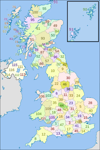
England
The postal counties in England mostly matched the new county borders from 1974. But there were some differences, as noted below.
| Former postal county | Abbreviation | Geographic coverage | Map ref |
|---|---|---|---|
| Avon | 1 | ||
| Bedfordshire | Beds | 2 | |
| Berkshire | Berks | 3 | |
| Buckinghamshire | Bucks | 4 | |
| Cambridgeshire | Cambs | 5 | |
| Cheshire | Very different from the 1974 county borders; also went into Greater Manchester | 6 | |
| Cleveland | 7 | ||
| Cornwall | 8 | ||
| County Durham | Co Durham | 9 | |
| Cumbria | Also went into Northumberland and Dumfries & Galloway | 10 | |
| Derbyshire | 11 | ||
| Devon | 12 | ||
| Dorset | 13 | ||
| East Sussex | E Sussex | 14 | |
| Essex | Very different from the 1974 county borders; also went into Greater London; Stansted post town (CM24 postcode) was a separate area inside Hertfordshire | 15 | |
| Gloucestershire | Glos | 16 | |
| Hampshire | Hants | 17 | |
| Herefordshire | Covered part of Hereford and Worcester; also went into Powys. | 18 | |
| Hertfordshire | Herts | Very different from the 1974 county borders; also went into Greater London | 19 |
| Isle of Wight | 20 | ||
| Kent | Also went into Greater London | 21 | |
| Lancashire | Lancs | Very different from the 1974 county borders; also went into Cumbria, Greater Manchester, North Yorkshire and West Yorkshire | 22 |
| Leicestershire | Leics | 23 | |
| Lincolnshire | Lincs | 24 | |
| London | Not a postal county, but the London postal district was a special post town | 25 | |
| Merseyside | 26 | ||
| Middlesex | Middx | Covered parts of Greater London and Surrey; Enfield post town was a separate area, cut off by London and Hertfordshire | 27 |
| Norfolk | 28 | ||
| North Humberside | N Humberside | Covered part of Humberside | 29 |
| North Yorkshire | N Yorkshire | 30 | |
| Northamptonshire | Northants | 31 | |
| Northumberland | Northd | Very different from the 1974 county borders; had two separate areas divided by Tyne & Wear (NE19 postcode) | 32 |
| Nottinghamshire | Notts | 33 | |
| Oxfordshire | Oxon | 34 | |
| Shropshire | Salop | 35 | |
| Somerset | 36 | ||
| South Humberside | S Humberside | Covered part of Humberside | 37 |
| South Yorkshire | S Yorkshire | 38 | |
| Staffordshire | Staffs | 39 | |
| Suffolk | 40 | ||
| Surrey | Very different from the 1974 county borders; also went into Greater London and didn't include Spelthorne (which was in Middlesex) | 41 | |
| Tyne and Wear | Tyne & Wear | Very different from the 1974 county borders; had a long narrow part reaching to the Scottish border (NE19 postcode) | 42 |
| Warwickshire | Warks | Very different from the 1974 county borders; had two separate areas divided by West Midlands (the eastern part of the Coventry post town) | 43 |
| West Midlands | W Midlands | Very different from the 1974 county borders; went into Warwickshire all the way to the Leicestershire border (CV7 postcode) | 44 |
| West Sussex | W Sussex | 45 | |
| West Yorkshire | W Yorkshire | 46 | |
| Wiltshire | Wilts | 47 | |
| Worcestershire | Worcs | Covered part of Hereford and Worcester | 48 |
Scotland
Scotland's postal counties generally followed the old civil counties on the mainland. Islands were treated as their own postal counties.
|
|
Wales
The postal counties in Wales mostly matched the new counties created between 1974 and 1996.
| Former postal county | Abbreviation | Geographic coverage | Map ref |
|---|---|---|---|
| Clwyd | Mostly matched the 1974–1996 counties | 103 | |
| Dyfed | 104 | ||
| Gwent | 105 | ||
| Gwynedd | 106 | ||
| Mid Glamorgan | M Glam | 107 | |
| South Glamorgan | S Glam | 108 | |
| Powys | 109 | ||
| West Glamorgan | W Glam | 110 |
Northern Ireland
In Northern Ireland, counties are usually called "County" plus the name (e.g., County Antrim). This helps avoid confusion with towns that have the same name.
| Former postal county | Abbreviation | Map ref |
|---|---|---|
| County Antrim | Co Antrim | 111 |
| County Armagh | Co Armagh | 112 |
| County Down | Co Down | 113 |
| County Fermanagh | Co Fermanagh | 114 |
| County Londonderry | Co Londonderry | 115 |
| County Tyrone | Co Tyrone | 116 |
After 1996: The End of Postal Counties
How Postcodes Took Over
In 1996, Royal Mail updated its sorting machines. They no longer needed postal counties to sort mail. Instead, they started using the "outward code" (the first half) of the postcode. This code helps them tell apart towns with similar names.
By 2000, postal county information was removed from Royal Mail's main address database. It was moved to a different file, used for cleaning up address data. Royal Mail's policy is that counties are not needed for addresses. They don't update this old county data.
Customers are told that only the correct post town and postcode are required in an address. You can still add a county if you want, but Royal Mail's machines will ignore it.
Why Some Still Use Old Counties
Even though Royal Mail says counties are not needed, many companies still include them in addresses. This is often because their computer systems are set up to use them. Sometimes, they even add counties to addresses that never needed them in the first place.
This has caused problems for people who live in areas where the postal county was different from the real geographic county. They often complained to Royal Mail.
In 2007, after a big campaign, Royal Mail agreed to create a postal county for Rutland. This happened in 2008. But other campaigns, like one in Seaton Delaval to remove Tyne and Wear from their address, were not successful.
In 2009, there was a discussion about Royal Mail's rules. It was noted that even though the old postal county data was outdated, it was the most common county data available to companies. Many people said they didn't like using old county names.
In 2010, Royal Mail was advised to stop providing county data completely. They planned for this to happen between 2013 and 2016.
In 2013, Royal Mail confirmed their position. They said their address file doesn't have county names because they aren't needed for mail. They do offer a list of historical county names, but they don't encourage companies to use them.
Later in 2013, there was another discussion about removing some or all county data from the old files. The results were published in 2014.
 | Misty Copeland |
 | Raven Wilkinson |
 | Debra Austin |
 | Aesha Ash |


