
Great Ayton facts for kids
Quick facts for kids Great Ayton |
|
|---|---|
 Footbridge over the River Leven in Low Green |
|
| Population | 4,346 (2021 census) |
| OS grid reference | NZ565115 |
| Civil parish |
|
| Unitary authority |
|
| Ceremonial county | |
| Region | |
| Country | England |
| Sovereign state | United Kingdom |
| Post town | Middlesbrough |
| Postcode district | TS9 |
| Dialling code | 01642 |
| Police | North Yorkshire |
| Fire | North Yorkshire |
| Ambulance | Yorkshire |
| EU Parliament | Yorkshire and the Humber |
| UK Parliament |
|
Great Ayton is a lovely village in North Yorkshire, England. It's a "civil parish," which is like a local area with its own council. The River Leven flows right through the village. This river eventually joins the bigger River Tees. Great Ayton is just north of the beautiful North York Moors national park. In 2011, about 4,455 people lived here.
Contents
What's in a Name?
The name Great Ayton comes from an old English word, Ea-tun. This means 'river farm'. The river flowing through Great Ayton is the Leven. It is a smaller river that flows into the River Tees. The word 'Great' was added later. This helps to tell it apart from a nearby village called Little Ayton.
A Look Back in Time
In the 1700s and 1800s, Great Ayton was a busy place for different jobs. People worked in weaving, making cloth, and tanning, which is turning animal skins into leather. There were also places for brewing beer and making tiles.
Later, people started to dig for whinstone. This hard rock was used for building roads. They also mined for ironstone, a type of rock used to make iron. Other things found here were jet, a shiny black stone, and alum, a mineral.
Great Ayton was also home to the Great Ayton Friends' School. This was a Quaker school that opened in 1841. It closed its doors in 1997. Today, the village is the base for the Cleveland Mountain Rescue Team. These brave volunteers help people who get lost or hurt in the nearby mountains.
Where is Great Ayton?

Great Ayton sits at the bottom of the Cleveland Hills. It is near famous landmarks like Easby Moor and the unique-looking Roseberry Topping. The River Leven flows through the village. It connects the two main parts of Great Ayton: High Green and Low Green.
A long, narrow band of hard rock called the Cleveland Dyke runs near the village. It stretches for about 31 miles (50 km). Great Ayton is close to the town of Middlesbrough. It is about 3 miles (5 km) south-east of Middlesbrough's built-up area. It is also about 3 miles (5 km) north-east of Stokesley.
Getting Around
The village has its own train station, Great Ayton railway station. It is on the Esk Valley Line. This train line connects different towns and villages in the area.
Famous Places and Statues
Many important places in Great Ayton are connected to Captain James Cook. He was a famous British explorer.
- An obelisk, which is a tall, thin stone monument, marks where the Cook family cottage once stood. The original cottage was taken apart and moved to Melbourne, Australia, in 1934! It was rebuilt there in Fitzroy Gardens. The obelisk in Great Ayton is made from granite. This stone came from Point Hicks, the first land Captain Cook saw in Australia.
- The Captain Cook Schoolroom Museum is in an old school building. A man named Michael Postgate started this school in 1704. James Cook went to school here from 1736 to 1740.
- On May 12, 1997, a statue of James Cook was put up on High Green. It shows him as a 16-year-old boy. He is looking towards Staithes, a fishing village. People say this is where he first felt like exploring the sea. A sculptor named Nicholas Dimbleby created this statue.
-
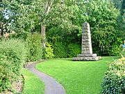
Cook family's Cottage obelisk
-
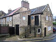
Captain Cook Schoolroom Museum
-
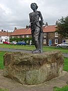
Statue of James Cook as a youth


Churches and Faith
The main church in Great Ayton is Christ Church. It was built in 1876. This church is now a Grade II listed building, meaning it's an important historical building. Many people attend its services each week.
In the summer, evening services are held at All Saints' Church. This church is much older, dating back to the 12th century. It has a special organ built by James Jepson Binns. There is also a Methodist Church, a Catholic church, and a Religious Society of Friends (Quaker meeting house) in the village. James Cook's mother and his brothers and sisters are buried in the churchyard of All Saints' Church.
-
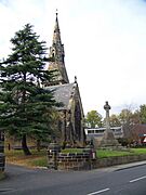
Christ Church
-
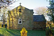
Church of All Saints


Famous People from Great Ayton
Great Ayton was the childhood home of Captain James Cook. He was a famous British explorer and navigator. He was born in nearby Marton. James Cook and his family moved to Great Ayton when he was eight years old. He lived there until he was sixteen.
His family home on Bridge Street was built by James' father in 1755. This cottage was taken apart in 1934. It was then shipped to Australia. Each stone was numbered carefully. This made sure the cottage could be put back together exactly the same way. It now stands in the Fitzroy Gardens in Melbourne.
Cyclist brothers Harry Tanfield (born 1994) and Charlie Tanfield (born 1996) were born in the village. They both celebrate their birthday on November 17th!
See also
 In Spanish: Great Ayton para niños
