Roseberry Topping facts for kids
Quick facts for kids Roseberry Topping |
|
|---|---|

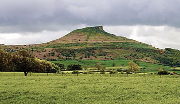
Roseberry Topping as seen from the north
|
|
| Highest point | |
| Elevation | 320 m (1,050 ft) |
| Prominence | 81 m (266 ft) |
| Geography | |
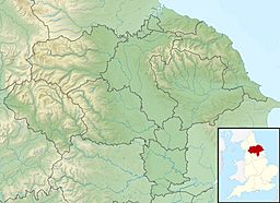
| Location | North York Moors, England |
| OS grid | NZ579126 |
| Topo map | OS Landranger 193 |
Roseberry Topping is a famous hill in North Yorkshire, England. It stands out because of its unique shape, looking a bit like a half-cone with a sharp cliff at the top. People often compare it to the much taller Matterhorn mountain in the Swiss-Italian Alps. This special hill is so well-known that it's even part of the logo for Teesside International Airport nearby!
Roseberry Topping is about 320 meters (1,049 feet) tall. For a long time, people thought it was the tallest hill in the North York Moors. However, there are actually 15 higher peaks, with Urra Moor being the highest at about 454 meters (1,490 feet). From the top of Roseberry Topping, you can see amazing views. You might spot Captain Cook's Monument at Easby Moor or the monument at Eston Nab, which used to be a beacon.
How Roseberry Topping Was Formed
Roseberry Topping is a separate part of the North York Moors uplands. It's made from sandstone that formed millions of years ago, between 208 and 165 million years ago. This is some of the newest sandstone found in England and Wales' national parks.
Its cool, cone-like shape happened because a hard cap of sandstone on top protected the softer shales and clays underneath. These softer layers would have worn away easily from ice, wind, and rain.
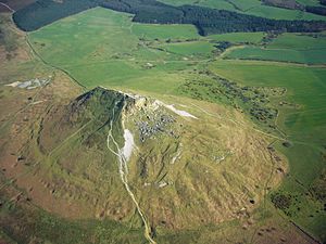
Before 1912, the top of the hill looked more like a "sugarloaf" (a rounded cone). But then, a crack in the ground, called a geological fault, caused part of the summit to collapse. Mining for alum and ironstone nearby might also have played a part. Even today, the area right below the top still has many holes and scars from these old mines. On a clear day, you can see for miles from the summit, all the way to the Pennines mountains, which are 60 to 80 kilometers (40 to 50 miles) away!
A Look at Roseberry Topping's History
People have lived around Roseberry Topping for thousands of years. Its unique shape has always caught people's attention.
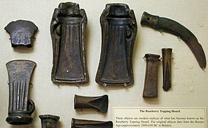
- Ancient Times: A collection of Bronze Age treasures was found on the hill's slopes. These items are now kept at the Sheffield City Museum. During the Iron Age, people lived here too. You can still see the remains of walled areas and huts from that time. It's possible that jet (a type of gemstone) was mined in the area back then.
- Viking Influence: The Vikings settled in Cleveland during the early Middle Ages. They gave many places in the area their names, including Roseberry Topping. The name first appeared in 1119 as "Othenesberg." The second part, "berg," comes from an Old Norse word meaning "rock." The first part might be from a Viking person's name, Authunn, or even from the Norse god Odin. If it's from Odin, Roseberry Topping is one of the few places in England named after a pagan god! The name slowly changed over time to what we know today. "Topping" is a local word from Yorkshire meaning "top of a hill."
- Captain Cook's Connection: In 1736, the family of famous explorer James Cook moved to a farm near Great Ayton. When young James wasn't helping his father on the farm, he would often climb Roseberry Topping. This hill gave him his first taste of adventure and exploring, which stayed with him his whole life.
- Weather Predictor: Roseberry Topping can be seen from far away. For a long time, sailors and farmers used it to guess if bad weather was coming. There's an old rhyme about it:
-
- When Roseberry Topping wears a cap, let Cleveland then beware of a clap!
This means if clouds cover the top of the hill, a storm might be on its way!
- Public Access: For many years, the hill was private land, part of an estate owned by the Cressy family. In the 1700s, a Cressy family member married Archibald Primrose, who later became the Earl of Rosebery. Today, Roseberry Topping is looked after by the National Trust and is open for everyone to visit. It sits just inside the North York Moors National Park.
- Walking Trails: A path from the Cleveland Way National Trail leads right up to the summit. People have been visiting the peak for centuries to enjoy the amazing views of the Cleveland area. As far back as the 1700s, travelers were told to visit the hill to see "the most delightful prospect upon the valleys below to the hills above."
- Special Protection: In 1954, Roseberry Topping was recognized as a Site of Special Scientific Interest (SSSI) because of its unique geology. This means it's a nationally important area for its rocks and landforms. The protected area was made larger in 1986 and now covers about 10.86 hectares.
 | Leon Lynch |
 | Milton P. Webster |
 | Ferdinand Smith |


