
River Leven, North Yorkshire facts for kids
Quick facts for kids River Leven |
|
|---|---|

The mouth of the Leven.
|
|
| Country | England |
| Physical characteristics | |
| Main source | Kildale Moor, North Yorkshire 279 metres (915 ft) 54°27′50″N 1°2′47″W / 54.46389°N 1.04639°W |
| River mouth | River Tees at Yarm 16 metres (52 ft) 54°30′31″N 1°20′12″W / 54.50861°N 1.33667°W |
| Length | 46.2 kilometres (28.7 mi) |
| Basin features | |
| Basin size | 196.3 square kilometres (75.8 sq mi) |
The River Leven is a river in North Yorkshire, England. It's like a smaller stream that flows into a bigger river, which is called the River Tees. The Leven starts high up on a place called Warren Moor, which is part of the North York Moors. From there, it travels north until it meets the River Tees near a town called Yarm.
Contents
The River's Journey
The River Leven begins its journey on Warren Moor. This moor is just south of the village of Kildale. At first, the river flows east. Then, it reaches the railway line that goes from Whitby to Middlesbrough. Here, the river makes a big turn. It starts flowing west towards Kildale.
After Kildale, the river heads south-south-west. It winds through forests. It then meets another stream called Dundale Beck. At this point, the Leven turns again. It flows north-west through Low Easby and Little Ayton. Next, it turns west, then south-west at Great Ayton. The river then runs next to the A173 road all the way to Stokesley.
As the river continues, it starts to curve a lot. It passes Skutterskelfe and goes towards Hutton Rudby and Rudby. Here, it turns north-west, then west again. It even goes over a small waterfall called Slape Stones. At Crathorne, it turns north, then north-east. It passes Middleton-on-Leven and goes under the A19 road. The last few miles of the river flow north and north-west. It runs between Ingleby Barwick and Yarm. Finally, the River Leven joins the larger River Tees.
River Bed and Rocks
The River Leven flows over different types of ground. Most of the rocks under the river are from the Permian and Jurassic periods. These rocks don't let much water pass through them. On top of these rocks, there is a lot of "boulder clay." This is a mix of clay and rocks left behind by glaciers. Near where the river starts, you can find moorland and forests. Further along, the land is used for farming.
River Life and Nature
For a long time, some fish and animals couldn't live in parts of the River Leven. This was because a weir (a small dam) was built during the time of the Industrial Revolution. This weir stopped fish from moving freely up and down the river.
In 2007, a group called the Environment Agency built a special "fish bypass" at the weir. This bypass helps fish swim around the barrier. It was a big success! In 2011, they announced that Atlantic salmon were returning to the river to lay their eggs. This was the first time in 150 years that salmon had been seen spawning there.
However, in 2020, some sad news came. A disease called "crayfish plague" was found in the river. More than 40 dead white-clawed crayfish were discovered. This disease is very dangerous for these native crayfish.
River History
The River Leven has been important to people for a long time. In Stokesley, there's a very old bridge called Taylorson's Bridge. It's a packhorse bridge from the 1600s. For many years, it was the only way to cross the river in the town.
The Domesday Book, a famous survey from hundreds of years ago, mentions a water mill on the river in Stokesley. Water mills use the power of the river to grind grain or do other work. In Hutton Rudby, there's a plaque on a bridge. It marks the spot where another water mill once stood. This mill was used for many things, including making sailcloth for ships!
River Connections
Smaller Streams Joining the Leven
|
Towns and Villages Along the Leven
|
Bridges and Crossings
|
Images for kids
-
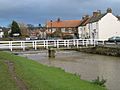
Bridge over the Leven at Great Ayton
-
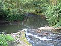
Coul Beck joining the River Leven near Rudby
-
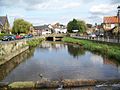
River Leven, Great Ayton
-
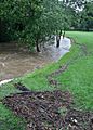
River Leven, Low Green, Great Ayton


