
River Tees facts for kids
Quick facts for kids River Tees |
|
|---|---|

High Force on the River Tees
|
|
.png)
Course of the Tees [1]
|
|
| Country | England |
| Region | Cumbria, Durham, Yorkshire |
| Physical characteristics | |
| Main source | Cross Fell 2,474 ft (754 m) 54°42′02″N 2°28′02″W / 54.7006°N 2.4673°W |
| River mouth | North Sea between Seal Sands and Redcar 0 ft (0 m) 54°38′54″N 1°08′51″W / 54.6483°N 1.1474°W |
| Length | 85 mi (137 km) |
| Basin features | |
| Basin size | 708 sq mi (1,834 km2) |
| Tributaries | |
The River Tees is a river in England. It starts high up on Cross Fell in the North Pennines. From there, it flows east for about 137 kilometers (85 miles). Finally, it reaches the North Sea in the North East of England.
For a long time, the river has been important for industries in the Teesside area. It helped bring in and send out goods. Also, to make sure there was enough water for factories, large reservoirs like Cow Green were built far upstream.
Contents
What Does the Name Tees Mean?
The name Tees might come from an old language called Common Brittonic.
- One idea is that it comes from the word *tēs. This word meant "warmth" and could also mean "boiling" or "excitement." The Welsh word tes has a similar meaning.
- Another idea is that it comes from *Teihx-s. This root might be linked to the Brittonic word *ti, which meant "dung" or "manure." The name of the River Tyne might have a similar origin.
Where Does the River Tees Flow?
The River Tees drains an area of about 1,834 square kilometers (710 square miles). Many smaller rivers flow into it. These are called tributaries. Some of the main ones include the River Greta, River Lune, River Balder, River Leven, and River Skerne.
The River's Path Through Counties
In the past, the river formed the border between County Durham and Yorkshire. Today, in its lower parts, it separates the ceremonial counties of County Durham and North Yorkshire. Higher up, it forms the border between the historic counties of Westmorland and Durham.
The Upper Teesdale Area
The area where the river starts is called Teesdale. It is a wild and beautiful place with moorland and hills. Some of these hills are taller than 760 meters (2,500 feet). This part of the river is within the North Pennines Area of Outstanding Natural Beauty.
The source of the river is at Teeshead, just below Cross Fell. It is about 732 meters (2,401 feet) high. The river flows through areas of Carboniferous Limestone. Below Viewing Hill, it turns south towards the Cow Green Reservoir. This reservoir stores water for industries further downstream.
Waterfalls and Valleys
After leaving the reservoir, the river flows over hard black rocks like basalt. This creates many waterfalls and rapids. One famous spot is Cauldron Snout. From here, the Tees forms the border between Durham and Yorkshire.
The valley gets wider below Cauldron Snout. Trees start to appear, making a nice contrast with the rocky areas. The river then flows over High Force, a 21-meter (69-foot) waterfall. About 2.4 kilometers (1.5 miles) downstream is the smaller Low Force waterfall.

The scenery becomes softer and more beautiful as the river flows past Middleton-in-Teesdale. This area has lead and ironstone resources. East of Middleton-in-Teesdale, the River Lune joins the Tees. Further on, the River Balder joins the Tees at Cotherstone.
The river then passes the old town of Barnard Castle, Egglestone Abbey, and Rokeby Park. At Rokeby, the River Greta joins the Tees. From here, the valley opens up into a rich plain. The river makes large curves as it flows east and south of Darlington.
Lower Reaches of the River
The river's path generally goes east-south-east. But near Whorlton, it turns north-east. It flows past Ovington and Winston, then alongside the A67 past Gainford and Piercebridge to Darlington. It goes under the A1 and A66 roads.
At Croft-on-Tees, the River Skerne joins the Tees. The river then flows south past Croft-on-Tees before turning north past Hurworth-on-Tees. It makes big bends past Neasham, Low Dinsdale, and Sockburn to Middleton St George. In these lower parts, the water flows over bunter sandstone and pebble beds.
Just past Yarm, the River Leven joins the Tees. Then the river passes Eaglescliffe, Ingleby Barwick, and Thornaby-on-Tees. As it gets closer to the sea, the Tees becomes a busy waterway for trade. The ports of Stockton-on-Tees and Middlesbrough are on its banks. The river flows through the Tees Barrage between these ports. Downstream from the barrage, the river becomes tidal, meaning its water level changes with the ocean tides.
Teesport is a large port built on land that was created from the sea. It is on the south side of the Tees estuary, below Middlesbrough.
How Water Levels Are Measured
The table below shows how water levels are measured at different points along the River Tees. These measurements help people understand the river's flow.
| Monitoring station | Station elevation | Low water level | High water level | Record high level |
|---|---|---|---|---|
| Middleton-on-Tees | 216 m (709 ft) | 0.37 m (1.2 ft) | 1.5 m (4.9 ft) | 3.19 m (10.5 ft) |
| Barnard Castle (Startforth) | 141 m (463 ft) | 0.46 m (1.5 ft) | 1.4 m (4.6 ft) | 2.68 m (8.8 ft) |
| Broken Scar (Darlington) | 41 m (135 ft) | 0.54 m (1.8 ft) | 1.7 m (5.6 ft) | 3.28 m (10.8 ft) |
| Low Moor (Low Dinsdale) | 18 m (59 ft) | 0.31 m (1.0 ft) | 4 m (13 ft) | 6.32 m (20.7 ft) |
| Yarm | 7 m (23 ft) | 0.45 m (1.5 ft) | 2.05 m (6.7 ft) | 4.08 m (13.4 ft) |
- The low and high water levels shown are average numbers.
Seal Sands: A Home for Seals
Seal Sands is an area in the Tees estuary. Before many factories were built, common seals lived there. For about 100 years, these seals were gone from the estuary. But now, they have returned! You can see them on the flats at Seal Sands. This area is now called the Teesmouth National Nature Reserve.
How the River Tees Has Changed Over Time

In 1769, people suggested making "cuts" in the river. These cuts would make the river straighter. This would save ships time and money when sailing. Between Stockton-on-Tees and Middlesbrough, the river used to curve a lot.
Two cuts were made: the Mandale Cut in 1810 and the Portrack Cut in 1831. These cuts straightened the river's path. Before the cuts, a trip by sailing boat from Thornaby to the mouth of the Tees could take up to seven days. The Mandale Cut was about 200 meters (220 yards) long. The Portrack Cut was much longer, about 1,000 meters (1,100 yards). You can't see these old river bends today. The Tees Barrage is near where the Mandale Cut was.
Since these cuts, the river has been changed more. Its bed and banks have been altered to make it deeper and easier for ships to use. The river channel has been made narrower by adding things like ship's ballast and slag from ironworks. This makes the water flow faster. Old maps show the river was once up to 300 meters (330 yards) wide in some places. Now, it is usually between 100 meters (110 yards) and 200 meters (220 yards) wide.
In 2021, a company started building the South Bank Quay project. This will be a deep-water facility. About 2 million tonnes of material will be dug out. This will allow huge wind turbine blades to be loaded onto ships. These 107-meter (351-foot) long blades are for the Dogger Bank Wind Farm.
Industry Along the River Tees
The River Tees has been used to transport industrial goods since the Industrial Revolution. It was especially important for shipping coal from the Durham Coalfields. Later, it helped the steel industries that grew up around Middlesbrough.
In the early days, merchant ships loaded goods in Yarm and Stockton on Tees. But as ships got bigger, new, deeper docks were built in Middlesbrough. Later, even larger docks were built at Teesport, closer to the sea.
The growth of the steel industry in the late 1800s gave the river the nickname "The Steel River." This was because so many steelworks operated along its banks. In the 1900s, the river also became important for the growing chemical industry. Companies like Imperial Chemical Industries (ICI) used land along the river for importing and exporting chemicals.
The need to load coal onto bigger ships in Middlesbrough helped the town grow. It also led to the development of the railway between Stockton and Darlington. This is where George Stephenson created his "Locomotion" engine. This railway was the first steam railway to carry passengers and industrial materials.
Today, Teesport is owned by PD Ports. It is near the North Sea, about 5 kilometers (3 miles) east of Middlesbrough. Teesport is the third largest port in the United Kingdom. It is also one of the ten biggest in Western Europe. It handles over 56 million tonnes of goods each year. Most of these goods are still related to the steel and chemical industries.
Large chemical factories are located in Billingham and Seal Sands on the north bank. Wilton is on the south bank. The Teesside Steelworks at Redcar operated until it closed in 2015.
Other companies along the River Tees work with the North Sea oil and gas industry. They also work in the renewable energy industry, like building offshore wind turbines. Near the mouth of the river is the 62-megawatt Teesside Offshore Wind Farm. It was built between 2011 and 2013.
The ABLE UK company has a large dry dock facility called TERRC. It is used to take apart old oil rigs and other big ships. Hartlepool Nuclear Power Station is also nearby.
Mysteries and Stories
Peg Powler is a character from English folklore. She is said to be a hag who lives in the River Tees.
The River Tees in TV Shows
The River Tees has been shown in television series. It was featured in Seven Natural Wonders as one of the wonders of the North. It also appeared in the drama The Last Train, where it was shown after its banks had flooded.
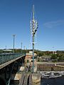
Bridges and Crossings
Many bridges cross the River Tees. They help people and vehicles get from one side to the other.
Gallery
-
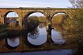
Yarm Viaduct
-

Infinity Bridge
-
Tees Barrage with White Water course in background
-
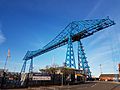
Tees Transporter Bridge


See also
 In Spanish: Río Tees para niños
