Cleveland Hills facts for kids
Quick facts for kids The Cleveland Hills |
|
|---|---|

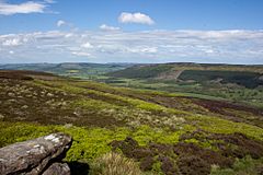
The Cleveland Hills viewed from Urra Moor
|
|
| Location | North Yorkshire, England |
| Nearest city | Middlesbrough, England |
| Governing body | North York Moors National Park Authority |
| Website | northyorkmoors.org.uk |
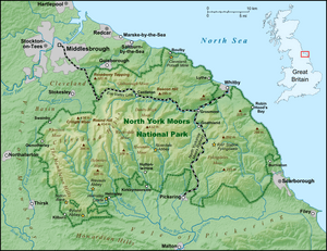
The Cleveland Hills are a group of hills in North Yorkshire, England. They are on the edge of the North York Moors National Park, looking over the areas of Cleveland and Teesside. These hills are completely inside the North York Moors National Park.
A part of the 110-mile long Cleveland Way National Trail runs along these hills. The famous Coast to Coast Walk by Alfred Wainwright also crosses them. The hills rise steeply from the flat Tees Valley to the north. They include well-known spots like Roseberry Topping, a cone-shaped hill near Great Ayton. This village was the childhood home of Captain James Cook.
Contents
How the Cleveland Hills Were Formed
The Cleveland Hills are made of many layers of rock, stacked up like pancakes. These rocks formed a very long time ago, during the Jurassic period (when dinosaurs lived!). Most of these layers are sedimentary rocks. This means they formed from tiny bits of sand, mud, and shells that settled over time and got squashed together.
The lower parts of the hills are mostly made of mudstone. As you go higher, you find different types of rock layers. These include:
- Ravenscar Group (from the Middle Jurassic period)
- Scalby Formation
- Scarborough Formation
- Cloughton Formation
- Eller Beck Formation
- Saltwick Formation
- Dogger Formation
- Lias Group (from the Early Jurassic period)
- Whitby Mudstone Formation
- Cleveland Ironstone Formation
- Staithes Sandstone Formation
- Redcar Mudstone Formation
Most of these rock layers are combinations of sandstone, mudstone, and siltstone. Some also have limestone. The Cleveland Ironstone and Eller Beck formations contain ironstone. This ironstone was very important for making iron in the past.
The flat tops of the hills are mostly made of sandstone. Roseberry Topping, a famous cone-shaped hill, is a bit separate from the main hills. It was once part of the same rock layers but got separated by erosion over time.
A type of rock called the Cleveland Dyke cuts through the hills. This rock is found in places like the Langbaurgh Ridge. It's a hard, dark rock that was used for building roads.
You can also find peat (decayed plant matter) on some flat areas of the hills. Landslides are common in the western parts of the hills.
History of the Cleveland Hills
Early People in the Hills
People have lived in the Cleveland Hills area for a very long time. You can find ancient burial mounds called tumuli and stone circles scattered around. These date back to the Bronze Age, which was thousands of years ago. There are also many cairns, which are piles of stones. Some of these are very old, while others are more recent.
During digs, hundreds of flint arrowheads have been found. These tools are from the Mesolithic and Neolithic periods, even earlier than the Bronze Age. This shows that many people lived and hunted in this area long ago.
Stone Circles in the Cleveland Hills
- Commondale
- Tripsdale "Bride Stones"
- Thimbleby "Nine Stones"
Mining and Industry
The Cleveland Hills played a big part in the history of industry in England. In 1850, a man named John Marley discovered ironstone in the Eston Hills. These hills are part of the Cleveland Hills. This discovery led to a lot of mining, and the nearby town of Middlesbrough grew very quickly.
By the 1870s, the area was making huge amounts of steel. People also mined for coal, alum, jet, and potash from the hills. Quarries were used to get sandstone and limestone. Many of these old mines and quarries can still be seen today.
Highest Hills in the Area
Here are some of the highest or most well-known hills in the Cleveland Hills range:
| Name | Grid reference | Height | |
|---|---|---|---|
| Urra Moor (Round Hill) | 454 m | 1,490 ft | |
| Cringle Moor | 432 m | 1,417 ft | |
| Carlton Bank | 408 m | 1,339 ft | |
| Cold Moor | 402 m | 1,319 ft | |
| Hasty Bank | 398 m | 1,306 ft | |
| Tidy Brown Hill | 396 m | 1,299 ft | |
| Bilsdale West Moor | 395 m | 1,296 ft | |
| Warren Moor | 335 m | 1,099 ft | |
| Gisborough Moor | 328 m | 1,076 ft | |
| Easby Moor | 324 m | 1,063 ft | |
| Park Nab | 324 m | 1,063 ft | |
| Roseberry Topping | 320 m | 1,050 ft | |
| Live Moor | 315 m | 1,033 ft | |
| Highcliff Nab | 310 m | 1,017 ft | |
| Codhill Heights | 296 m | 971 ft | |
| Eston Nab | 242 m | 794 ft | |
Towns and Villages Near the Cleveland Hills
Many towns and villages are located on or near the Cleveland Hills. Some of these include:
- Carlton-in-Cleveland
- Easby
- Great Ayton
- Great Broughton
- Guisborough
- Kildale
- Middlesbrough
- Newton under Roseberry
- Osmotherley
- Redcar
- Saltburn
- Skelton-in-Cleveland
- Slapewath
- Staithes
- Stokesley
- Swainby
Interesting Places to Visit
There are several interesting places to visit in and around the Cleveland Hills:
- Captain Cook Birthplace Museum, Marton, Middlesbrough
- Captain Cook Monument, Easby Moor
- Captain Cook Schoolroom Museum, Great Ayton
- Roseberry Topping
- Wainstones, Hasty Bank
Bilsdale West Moor, which is in the Cleveland Hills, is home to the 314-meter tall Bilsdale transmitting station. This tall mast sends out digital TV and radio signals. It covers a large area of the north-east, about 40–50 miles wide.
 | May Edward Chinn |
 | Rebecca Cole |
 | Alexa Canady |
 | Dorothy Lavinia Brown |


