
Cringle Moor facts for kids
Quick facts for kids Cringle Moor |
|
|---|---|

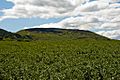
Cringle Moor seen from the east
|
|
| Highest point | |
| Elevation | 434 m (1,424 ft) |
| Prominence | 175 m (574 ft) |
| Listing | Marilyn |
| Geography | |
| Location | North York Moors, England |
| OS grid | NZ537029 |
| Topo map | OS Landranger 93 |
Cringle Moor (sometimes called Cranimoor) is a tall hill in the North York Moors area of England. It stands 432 meters (about 1,417 feet) high. This makes it the third highest hill in the North York Moors. It is also the tallest point west of a place called Clay Bank.
Cringle Moor is a popular spot for hikers. It is part of two famous long-distance walking paths. One is the Cleveland Way, which is a special walking route called a National Trail. The other is Coast to Coast Walk, created by a famous walker named Alfred Wainwright. He thought this part of the walk was "one of the finest." The hill is also part of the challenging Lyke Wake Walk.
Ancient History on Cringle Moor
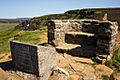
Just west of the top of Cringle Moor, you can find something very old. It is a burial mound called Drake Howe. A "howe" is an old word from the Vikings (Old Norse) meaning a burial mound.
What is Drake Howe?
Drake Howe is a burial mound from the Bronze Age. This was a time long ago when people used bronze to make tools and weapons. The mound was built to bury people. Today, Drake Howe is a protected historical site. This means it is very important and looked after so it stays safe for the future.
Gallery
-
Cringle Moor from Bank Lane
-
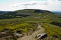
Cringle Moor from Cold Moor
-
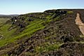
Cringle Moor's northern face
-
Stone seat on Cringle Moor
-
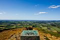
View north from Cringle Moor


