Point Hicks facts for kids
Quick facts for kids Point Hicks |
|
|---|---|
| Cape Everard | |

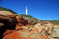
Point Hicks Lighthouse Stevage.jpg lighthouse]]
|
|
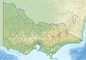
| Location | South East Corner (IBRA), Victoria, Australia |
| Coordinates | 37°48′11″S 149°16′32″E / 37.80306°S 149.27556°E |
Point Hicks, also known as Cape Everard for a time, is a piece of land that sticks out into the sea. It is located on the eastern coast of Victoria, Australia. Today, Point Hicks is part of the beautiful Croajingolong National Park.
Contents
How Point Hicks Got Its Name
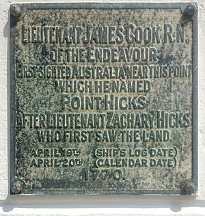
Point Hicks is a very important place in Australian history. On April 19, 1770, it was the first part of the continent of Australia seen by Europeans. This sighting happened during Captain Cook's famous journey on his ship, the Endeavour.
The Original Naming
Captain Cook wrote in his log that Lieutenant Zachary Hickes was the first person to spot the land. Because of this, Cook decided to name the point after him. Lieutenant Hickes spelled his last name with an "e" (Hickes). However, Captain Cook sometimes wrote it as "Hicks" and sometimes as "Hickes". The spelling "Hicks" is the one used for the point today.
The Name Change to Cape Everard
After Captain Cook's visit, the name "Point Hicks" was not used for a long time. When another explorer, George Bass, sailed past in 1797, he did not find the point. It was not even on the maps made by Matthew Flinders from their voyages.
Later, the area became known as Cape Everard. It is believed that John Lort Stokes, a mapmaker, first used this name in 1843. He was surveying the coast on a ship called the Beagle. People think he named it after a naval officer named John Everard Home. However, Stokes' own maps do not actually show the name "Cape Everard".
The first map that officially showed "Cape Everard" was made in 1852 by a surveyor named George Douglas Smythe. It was published in 1853. Some people think he might have named it after William Everard, who was a commissioner of crown lands. The name Cape Everard was used for many years, until 1970.
Returning to Point Hicks
There were some debates and questions about exactly what Captain Cook saw. The exact location he wrote down was actually many miles out at sea.
In 1970, the point was renamed Point Hicks again. This was done to celebrate the 200th anniversary of Captain Cook's arrival. The Premier of Victoria, Henry Bolte, announced the new name. This special ceremony took place on April 20, 1970. The date was chosen to match the 200th anniversary, even though Cook's original sighting was on April 19 by his ship's time. This difference is because of how time zones and the International Date Line work.
The Point Hicks Lighthouse
A tall lighthouse stands proudly on Point Hicks. It was built between 1887 and 1888 and started guiding ships in 1890. The lighthouse was made from concrete. The homes for the lighthouse keepers were built from wood.
Lighthouse Features
The lighthouse first got electricity in 1965. More recently, it has been updated to use solar power. The old houses where the lighthouse keepers lived are now used as holiday homes. People can stay there and enjoy the beautiful coastal views.
The Point Hicks Lighthouse is 37 meters (about 121 feet) tall. This makes it the tallest lighthouse on the mainland of Australia. Its light shines from a height of 56 meters (about 184 feet) above sea level. The light flashes twice every ten seconds, helping ships navigate safely along the coast.
 | Mary Eliza Mahoney |
 | Susie King Taylor |
 | Ida Gray |
 | Eliza Ann Grier |


