Uppingham facts for kids
Quick facts for kids Uppingham |
|
|---|---|
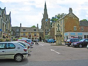
 The Market Place and church |
|
| Population | 4,745 Census 2011 |
| OS grid reference | SP865999 |
| Unitary authority | |
| Ceremonial county | |
| Region | |
| Country | England |
| Sovereign state | United Kingdom |
| Post town | OAKHAM |
| Postcode district | LE15 |
| Dialling code | 01572 |
| Police | Leicestershire |
| Fire | Leicestershire |
| Ambulance | East Midlands |
| EU Parliament | East Midlands |
| UK Parliament |
|
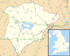
Uppingham is a small market town in Rutland, England. It is located off the A47 road. This road connects Leicester and Peterborough. Uppingham is about 6 miles (10 km) south of Oakham. In 2011, about 4,745 people lived there. By 2019, this number grew to an estimated 4,853.
The town is famous for Uppingham School. This is a well-known independent school. Uppingham also has many art galleries. This makes it a popular place for people who love art. In 2022, The Times newspaper called Uppingham the "best place to live in the Midlands". They said it was a "discerning market town with art, heart and smarts". They also mentioned the beautiful Rutland Water nearby.
Contents
What's in a Name?
The name Uppingham means 'Homestead or village of the Yppingas'. These were people who lived in the uplands. The town sits on a high ridge. This is why it is called "upland". It is near a place called Beaumont Chase.
A Look Back in Time
About one mile (1.6 km) northwest of Uppingham is Castle Hill. Here you can see the remains of an old motte and bailey castle. Uppingham became a market town in 1281. This happened when the local lord was allowed to hold a weekly market.
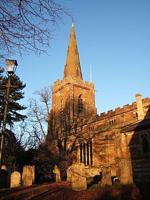
Uppingham has two active churches. The Church of St Peter and St Paul was built mostly in the 14th century. It is a Church of England parish church. The other is the Methodist Church on Orange Street. It was built in 1819 and made bigger later.
The Uppingham Workhouse was first mentioned in 1777. It could hold 40 people. Later, a new workhouse was built in 1836. During the First World War, this building became a hospital. Today, Uppingham School uses it as a boarding house for girls. It is called Constables.
The Eyebrook Reservoir is near Uppingham. It was used by Avro Lancaster planes for practice. These planes were from 617 Squadron, known as the Dambusters. They practiced here before their famous mission, Operation Chastise. This mission attacked dams in Germany in May 1943.
The Town Market
Uppingham holds its weekly market every Friday. Once a year in November, the Market Place changes. It becomes a place for a fatstock show. This show displays farm animals. It is one of the last shows of its kind held in a traditional market town. The first show was in 1889. In 2011, 140 sheep, 24 pigs, and 20 cattle were shown. Farmers from the area bring their best animals. They also celebrate with friends at The Falcon Hotel.
How Uppingham is Run
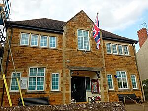
Uppingham has two levels of local government. These are the Uppingham Town Council and Rutland County Council. The Town Council works from Uppingham Town Hall. This building is at 49 High Street East. The County Council handles most local services. The Town Council looks after things like parks and cemeteries.
Uppingham has had a parish council since 1894. In 1980, the parish council changed its name. It became Uppingham Town Council. It also started to appoint a mayor. The building they use was renamed the Town Hall at the same time.
Learning in Uppingham
Uppingham has a state secondary school. It is called Uppingham Community College. There are also two primary schools: Leighfield and Uppingham C of E.
Uppingham School is an independent school. It is for students aged 13 to 18. It was started in 1584. Girls have been able to attend since 1975.
Art Scene
Uppingham is home to several art galleries. These galleries are well-known. The Goldmark Gallery has been selling art for over 40 years. They have more than 50,000 art pieces.
Local News and Media
You can get local news and TV from BBC East Midlands and ITV Central. TV signals come from the Waltham TV transmitter.
Local radio stations include:
- BBC Radio Leicester (104.9 FM)
- Smooth East Midlands (106.6 FM)
- Capital East Midlands (105.4 FM)
- Hits Radio East Midlands (106.0 FM)
- Greatest Hits Radio Midlands (107.2 FM)
- Rutland and Stamford Sound (on DAB)
The local newspapers are the Rutland Mercury and Rutland Times.
Getting Around
Trains
The closest train station is Oakham. It is about 6 miles (10 km) north. This station is on the Birmingham to Peterborough Line. This line connects Birmingham, Leicester, and Peterborough.
Another option is Corby station. It is about 9 miles (14 km) south. It offers frequent trains to London.
Uppingham railway station used to be here. It opened in 1894. Passenger trains stopped running in 1960. The line closed completely in 1964. Now, the old station area is an industrial estate.
Roads
An A47 bypass road opened in 1982. This road helps connect Uppingham to Peterborough and Leicester. The A6003 road also goes through the town. It links Uppingham with Oakham, Corby, and Kettering.
Buses
Centrebus runs most of the bus services. The main bus routes connect Uppingham with Oakham, Corby, Leicester, Peterborough, and Stamford.
Sports in Town
Uppingham has many sports activities. For example, Uppingham Town F.C. plays football at Tod's Piece. The Uppingham Town Cricket Club opened its new ground in 2011.
Uppingham School also has a new sports centre. Lord Coe, a famous athlete, opened it in 2010.
Uppingham Town Partnership
The 'Uppingham Town Partnership' is a group of volunteers. They work to make Uppingham a great place to live, work, and have fun. They get support from the Town Council and Rutland County Council.
This group organizes yearly events. These include "Uppingham Feast Day" in June. This is a music festival with food and entertainment. They also organize "Christmas in Uppingham". This event has late-night shopping and festive street fun. The volunteers also help other events. They support "Uppingham Films" which shows movies. They also help 'Uppingham in Bloom'. This group has won many gold medals for its beautiful flower displays.
See also
 In Spanish: Uppingham para niños
 | Emma Amos |
 | Edward Mitchell Bannister |
 | Larry D. Alexander |
 | Ernie Barnes |


