Cold Overton Park facts for kids
Quick facts for kids Cold Overton Park |
|
|---|---|

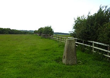
Cold Overton Park - triangulation pillar
|
|
| Highest point | |
| Elevation | 197 m (646 ft) |
| Listing | County Top |
| Geography | |
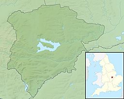
| Location | West of Oakham, England |
| OS grid | SK 827 085 |
| Topo map | OS Landranger 141 |
Cold Overton Park is a notable hill located in the county of Rutland, England. It holds the distinction of being the highest point in the entire county. This makes it a significant landmark for geography enthusiasts and visitors alike. The hill reaches an elevation of 197 meters (which is about 646 feet) above sea level.
Contents
What Makes Cold Overton Park Special?
The very top of Cold Overton Park features a special marker called a trig point. A trig point, short for triangulation pillar, is a concrete pillar used by mapmakers. They help surveyors accurately measure distances and create detailed maps of the land. This particular trig point is found just east of a wooded area known as Cold Overton Park Wood.
Where is Cold Overton Park Located?
This high point is situated southwest of a radio relay mast near Glebe Farm. You can find it along the road that connects the towns of Oakham and Knossington. The hill is also very close to the border between Rutland and the neighbouring county of Leicestershire. Its location makes it easy to spot for those travelling through the area.
What Can You See from the Top?
From the summit of Cold Overton Park, visitors can enjoy some lovely views. One of the most impressive sights is Rutland Water. This large artificial reservoir is a popular spot for outdoor activities and is a key feature of the Rutland landscape. Looking out from the peak, you get a great perspective of the surrounding countryside and this famous body of water.
A Bit of History
Cold Overton Park is part of a historic area known as Flitteriss Park. This suggests that the land has been recognized and used as parkland for a long time. Historic parks often have interesting stories and features that reflect their past uses, whether for hunting, recreation, or simply as managed natural spaces.
 | Dorothy Vaughan |
 | Charles Henry Turner |
 | Hildrus Poindexter |
 | Henry Cecil McBay |


