
Christopher Saxton facts for kids

Christopher Saxton (born around 1540 – died around 1610) was an English mapmaker. He created the very first maps of the counties of England and Wales.
Contents
Who Was Christopher Saxton?
Saxton was likely born in a place called Sowood, near Ossett, in Yorkshire. This was around 1542 or 1544. His family later moved to a small village called Dunningley.
People think Saxton might have gone to a school that later became Queen Elizabeth Grammar School in Wakefield. Some also guess he went to Cambridge University, but we don't have proof for either. It's most likely that John Rudd, a local church leader and a skilled mapmaker, taught Saxton his mapping skills.
Saxton got married and had three children. His son, Robert, born in 1585, helped his father with mapmaking. Robert even drew a map of Snapethorpe in Wakefield in 1601. Christopher Saxton passed away around 1610 or 1611.
Saxton's Amazing Maps


Making maps became much more popular during the time of Queen Elizabeth I. This was because new tools helped people survey land better. Also, new ways of printing from engraved copper plates made it easier to print maps.
Having accurate maps of the whole country became very important. An older map, the Gough Map from the 1300s, showed roads but didn't show the different parts of the country.
A powerful person named Lord Burghley helped make sure Saxton got the money he needed. A court official, Thomas Seckford, paid for Saxton's mapping project.
Mapping England and Wales
In 1574, Saxton began surveying England. Because this was a big and costly job, Queen Elizabeth gave him the right to use lands at Grigstone Manor in Suffolk. This helped pay for his work. The survey of Wales started in 1577.
Mapping the country was a huge task! But the first map plates were ready by 1574. The entire survey was finished in 1578. Since it was done so quickly, Saxton might have used some of John Rudd's earlier maps to help him.
Individual maps of counties were released first. Then, the complete collection was published as an atlas in 1579. Lord Burghley received the first copies and put them into his own atlas.
The Atlas of England and Wales
Saxton's maps were put together in a book called the Atlas of the Counties of England and Wales. It was published in 1579. This atlas had 35 maps. Each map showed the symbols of Queen Elizabeth I and Thomas Seckford, who supported Saxton.
The maps showed hills and mountains. However, they didn't give exact details about where they were or how tall they were. Different symbols showed buildings and towns. But the maps did not show any roads. All the maps had dates, except for the one of Northumberland. Five counties (Cornwall, Essex, Hertfordshire, Suffolk, and Norfolk) showed how they were divided into smaller areas called hundreds.
The atlas was very popular and sold well. This encouraged other mapmakers, like John Speed and Michael Drayton, to create their own maps. They often used and changed Saxton's work.
Who Engraved the Maps?
The maps Saxton drew were engraved by several skilled artists. Most of these engravers were from the Netherlands or Belgium. Their names included Augustine Ryther, Remigius Hogenberg, and William Hole.
There is no clear proof on the maps that Saxton engraved them himself. But some say he engraved the maps of the Welsh counties and Herefordshire. Saxton was given a special permission to sell his maps for ten years.
Later Uses of Saxton's Maps
In 1596, John Dee, who worked at the Manchester's collegiate church, asked Saxton to map the boundaries of Manchester's parish. Sadly, no copy of this map has survived.
Today, you can find a copy of Saxton's atlas at Chetham's Library in Manchester. Another copy is at the Folger Shakespeare Library in Washington, D.C.
Saxton's maps were even reprinted during the English Civil War. They were made into 20 strong sheets that could be folded into a pocket map. These were "Useful for all Commanders for the Quartering of Soldiers." Because of this, they became known as "the Quartermaster's map."
Images for kids
-
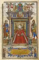
Frontispiece to Saxton's Atlas of the Counties of England and Wales
-
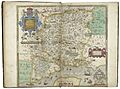
A map of "Southamptonshire" (modern day Hampshire) from the Atlas of the Counties of England and Wales
-
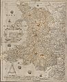
Saxton’s unpublished Proof Map of Wales, 1580
