
River Ancholme facts for kids
Quick facts for kids River Ancholme |
|
|---|---|

The old River Ancholme in Brigg
|
|
| Physical characteristics | |
| Main source | Bishopbridge, Lincolnshire |
| River mouth | South Ferriby, Lincolnshire (The Humber, North Sea) |
| Length | 17 mi (27 km) (navigable) |
The River Ancholme is a river in Lincolnshire, England. It flows into the Humber. The river starts from a spring near Ingham. It then flows east and north to Bishopbridge, where the Rase joins it. After Bishopbridge, it goes through the town of Brigg. Finally, it empties into the Humber at South Ferriby. The Ancholme helps drain a large part of northern Lincolnshire.
People have used the river for a very long time, since at least 800 BC. Records show that people wanted to improve the river as early as 1287. A big change happened in 1635 when a new, straight channel was built. This new channel carries most of the water and is called the New River Ancholme. The Old River Ancholme still follows its natural winding path. Today, the old river is mostly a drain, except around Brigg. Here, the two rivers create an island called 'Island Carr'.
More improvements were made in the early 1800s by John Rennie and his son. The Ferriby Sluice was rebuilt around 1841. For a while, the river was good for business. Even though railways later reduced trade, it picked up again in the 1890s. Carrying sugar beet in the 1930s also helped. By the 1970s, commercial boats stopped using the upper part of the river. All commercial use ended in the 1980s.
The upper part of the river was in poor condition, but it was cleaned and restored in 2004. The River Ancholme is important for draining water from northern Lincolnshire. It is also used for fun activities like boating, rowing, canoeing, and fishing. The Environment Agency now manages the river.
The Ancholme Internal Drainage Board has 12 pumping stations along the river. These pumps move water from the low-lying land nearby to stop floods. The river also provides a lot of water to the Scunthorpe Steelworks. Anglian Water uses it to supply drinking water to industries near the Humber. To make sure there is enough water in dry times, water is brought from Barlings Eau (near the River Witham) through a special transfer scheme built in 1974.
Not many bridges over the river are public roads. Many of them are historic buildings. Ferriby Lock is a protected ancient monument. The river is also home to two old boats owned by the Humber Keel & Sloop Preservation Society.
Contents
River Ancholme: A Look Back in Time
The Ancholme valley was once a flat, marshy area. It used to be the bed of a large lake when the ice from the Ice Age melted. People have found evidence that boats used the river a very long time ago. For example, three ancient boats have been found. Two simple logboats were found at Brigg and Appleby. A more complex boat, made from oak planks sewn together, was found at Brigg in 1888. This boat was carbon-dated to about 800 BC. This means it is about 500 years younger than similar boats found near the Humber.
Other old finds near the river show how important it was. In the area of Bishop Norton, many ancient sites have been found. Most of these, including old settlements, are close to the Ancholme. They date from the Stone Age (Neolithic period) through the Bronze Age and Roman times. The oldest find was a handaxe from the Stone Age (Paleolithic period). It was found near Harlam Hill Lock. This axe, and several others from the Stone Age, are now in the Lincoln Museum.
The old river's path forms the boundary for many local areas. This suggests the river was a main route for travel and trade. It also provided for people's needs. Later, Roman roads took over as the main travel routes.
The river often got blocked with mud from the Humber. The land on both sides was also very wet. Still, the Ancholme was a way to reach communities in northern Lincolnshire. Boats carried goods on it from early times. In 1287, a special permission was given to improve the river. This was so boats could carry grain and other goods more easily, "as they had done formerly." However, local landowners mostly wanted the river to drain their lands and prevent floods. Between 1289 and 1418, the river was mentioned many times in official records. These records always talked about keeping the channel clear, but not always about boats.
The river went through cycles of problems, improvements, and then neglect. In 1635, a local landowner named Sir John Monson was allowed to build a new river for drainage. He straightened out most of the bends. This created a new, straight channel from Bishopbridge to Ferriby. The main goal was drainage. However, it also said that the new work should not make the river worse for boats. At Ferriby, a sluice was built to control mud from the Humber. It had three arches and 24 doors. It is not clear how boats passed through it.
At Brigg, the new channel went around the town. But the old channel was also kept. This helped protect the town from floods. This project was part of bigger "fenland improvements" happening in England in the 1630s.
In 1724, a visitor named William Stukeley wrote that the sluices were "broken down" due to neglect. Things got worse. In 1766, landowners hired Thomas Yeoman to survey the river. He found that the Ferriby Sluice was broken. This caused mud to build up in the river for many miles. In some places, the river had become very narrow. This meant it could not handle floodwaters well. The last five miles to Bishopbridge were completely blocked with mud. In 1767, a new law was passed to allow improvements for both boating and drainage.
How the River Was Used

The river became an important way to move goods from farms to towns like Beverley and Hull. In 1793, William Colton started a boat service between Brigg and Hull. By 1823, he was using a steam-powered boat. It left Brigg every day at 7 am and arrived in Hull by 10:30 am. The return trip left Hull at 3 pm.
For many years, people paid to use the river. The amount of money collected from these payments steadily increased. It went from £402 in the 1780s to £1,857 per year by 1845. Then, it reached £3,020 for the next three years. However, when railways arrived, the payments dropped. Brigg railway station opened in 1848. By 1850, payments were down to £949.
After 30 years, trade improved a little. Payments reached £1,000 in the 1890s. The growth of the sugar beet industry in the 1930s boosted trade even more. Payments averaged £1,294 in the late 1930s. Bishopbridge was a key place for collecting and distributing goods. But by the 1970s, commercial boats only used the river between Ferriby and Brigg. All commercial traffic stopped by the 1980s.
Some improvements continued, like rebuilding bridges. In 1977, Ian Horsley started the Rase-Ancholme Navigation Trust. He suggested improving the upper part of the river. His big plans included new locks on the River Rase. This would link to Middle Rasen and Market Rasen. By the early 1980s, the plan grew to include links to Horncastle and the Foss Dyke. This would create a network of waterways in northern Lincolnshire. But the area was too quiet for such big plans to work. The Trust closed in 2009.
By the 1980s, the river above Harlam Hill lock was almost unused. The lock was repaired in 1993, but it was not fully successful. The Inland Waterways Association kept pushing for the lock to be fixed. They raised money to help. The Environment Agency cleaned and restored the upper part of the river in 2004. This work cost £100,000. It also added new places for boats to stop at Bishopbridge. There were also places for canoeists to get in and out of the water.
The top gate of Harlam Hill lock was replaced in 2010. However, the Environment Agency closed the lock again in 2012 for safety reasons. This means boats cannot go on the first two miles of the river. As of 2017, there are no plans to reopen it.
The lock at South Ferriby lets boats go between the river and the Humber. It is a tide lock, meaning it works with the changing tides. It has four sets of gates. Two are for when the Humber is higher than the river, and two for when it is lower. From the Humber, boats can reach many other waterways. They can also get to the North Sea. The river's water levels can change quickly after heavy rain. This is because the sluices are opened to prevent flooding. When this happens, all boating might be stopped.
How the River is Managed

Who was in charge of the river and flood defenses changed many times in the 20th century. In 1930, new laws created "catchment areas" for rivers. The Ancholme and Winterton Beck Catchment Area was one of them. A board was set up to manage it by 1931. This board was replaced by the Lincolnshire River Board in 1948. This new board also managed other rivers like the River Welland and the River Witham.
From 1951, the Ancholme Internal Drainage Board became responsible for land drainage. This board manages an area of about 68.77 square miles (178.1 km2). It looks after 119 miles (192 km) of water channels. About half the water that falls on this area has to be pumped into the River Ancholme. This is because the land is too low for water to drain by itself. The board has 12 pumping stations along the river.
The river's management changed again in 1963. The river board was replaced by the Lincolnshire River Authority. Then, in 1973, it became part of Anglian Water. When water authorities became private companies in 1989, the National Rivers Authority (NRA) took over river management. Finally, the NRA became part of the Environment Agency in 1996.
Fun on the River Ancholme
The River Ancholme is not just for drainage and water supply. It is also used for fun activities! The Environment Agency manages the river. All boats need to be registered and have a valid license. Over 200 boats are registered. There are places to moor boats at Ferriby, Brigg, Brandy Wharf, and Bishopbridge. Getting into the Humber from the river can be tricky. There are large mud banks that appear at low tide. So, boats can only pass through South Ferriby lock about three hours before or after high tide.
The river is big enough for small barges and medium-sized cabin cruisers. South Ferriby lock is 68 by 18 feet (20.7 by 5.5 m). Harlam Hill lock is smaller, at 60 by 16 feet (18.3 by 4.9 m). But boats longer than 40 feet (12 m) cannot turn around above this lock. Small boats can be launched from a ramp at Brandy Wharf Leisure Park.
The river is a popular place for rowing, kayaking, and canoeing. The Ancholme Rowing Club is in Brigg. It helps rowers of all skill levels. They encourage young members and offer lessons. They also organize two big events each year. The Ancholme Head race is a 2,750-metre (3,010 yd) course for different categories of rowers. The Scrumpy Row is a more relaxed, social event. It covers 6 miles (9.7 km) from Brigg to Brandy Wharf. The Environment Agency works with the club to support rowing. They also have an agreement with the British Canoe Union. This allows their members to use the river. There are also some small sailing yachts on the river.
The river has many fish and is great for coarse fishing. There are fishing competitions every year, including in winter. These attract anglers from nearby areas. The river is also popular with walkers. There is a path along its entire length. The Ancholme has marinas at Brigg and South Ferriby. The South Ferriby marina has a shop for boat supplies and boat building facilities. About three-quarters of the boats that use the river can go out to sea. This is because the river provides easy access to the North Sea through the Humber.
Water for Homes and Industry

In the late 1960s, more water was needed, especially for industries near the Humber. Water from underground sources could not be increased. So, the Trent Witham Ancholme Transfer Scheme (TWA) was built in 1974. A pumping station at Short Ferry pumps water through 10.6 miles (17 km) of pipeline to a reservoir at Toft Newton. This reservoir covers 41 acres (16.5 ha). In dry periods, water is released from this reservoir into the Ancholme. This helps keep the river flowing and at a good level. If the pumps at Short Ferry stop working, the reservoir can keep the Ancholme flowing for up to seven days.
There is another pumping station at Torksey, on the River Trent. If the River Witham has low water levels, water is pumped from the Trent into the Foss Dyke. From there, it flows to Lincoln and the River Witham system.
In 1996, about 37,698 megalitres (8,292×106 imp gal) of water were taken from the river each year. Big users included British Steel plc, Centrica, and Anglian Water. British Steel takes water for the Scunthorpe Steelworks. Centrica runs the Glanford Brigg Power Station, a gas-fired power plant near Brigg. It uses river water for cooling. Some cooling water is returned to the river. Water is also treated to provide a clean supply for the power station's boilers.
The biggest user of water is Anglian Water. They have a pumping station near Cadney bridge. In 1996, they were allowed to take 31,000 megalitres (6,800×106 imp gal) of water per year. This was about 82% of all water taken from the river. After initial cleaning, water is pumped for 1.2 miles (1.9 km) through large pipelines to Cadney reservoir. This reservoir can hold 900 megalitres (200×106 imp gal) of water. After more cleaning, the water is pumped for another 6.2 miles (10 km) to Elsham Water Treatment Works. This plant produces up to 30 megalitres (6.6×10⁶ imp gal) of drinking water each day for public use.
Using water from the TWA scheme has other benefits too. Because the river flow is kept steady even in dry weather, there is less build-up of nutrients in the water. This helps keep the river healthy. The flow through Ferriby sluice also helps stop salty water from the Humber entering the river. The amount of water transferred by the TWA scheme changes with the weather. For example, in 1987, it was 2,425 megalitres (533×106 imp gal). But in 1979, it was much more, at 17,425 megalitres (3,833×106 imp gal).
The River's Journey
The Ancholme starts near Top Farm, West Firsby. It flows east, then turns northeast. It passes through the site of an old medieval village. Then it goes under Owmby Road. Soon, it turns north as it flows past Toft Newton reservoir. This reservoir helps add water to the river. It is also a popular place for trout fishing. In 1996, it was stocked with rainbow trout and brown trout twice a week. A special boat called a "wheelyboat" was bought. This boat allows people in wheelchairs to go fishing. The river then passes under Pilford Bridge and reaches Bishopbridge, where the A631 road crosses it.
The River Rase flows under a bridge next to the Ancholme. The two rivers then run side-by-side for about 2.5 miles (4 km). On the Ancholme, there is a sloping weir. This is where the part of the river that boats can use begins. Nearby is a large old warehouse. The towpath, a path for walking, starts on the western bank. Harlam Hill lock is about 2.5 miles (4.0 km) further. The bypass channel goes over a weir, and the water flows into the River Rase. The Rase then joins the Ancholme at Atterby weir, just below the lock. The lock gates are opened with thin metal poles instead of heavy wooden beams.
Snitterby bridge, also called Browns Bridge, is just below Atterby weir. Like most bridges over the river, it is not a public road. So, the Environment Agency maintains it. Brandy Wharf bridge, about 4 miles (6.4 km) from the start of the navigable part, is one of the two bridges on a public road. Next to it is an old brick warehouse, which is a Grade II listed building.

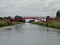
The towpath crosses to the east bank at Brandy Wharf bridge. A little further east is the Old Tollgate Bridge. This red brick bridge, built in the late 1700s, crosses the Old River Ancholme. Going north, the towpath crosses the entrance to the Caistor Canal. This canal has not been used since 1877. A modern steel bridge sits on stone supports built around 1785. This bridge is also Grade II listed, as is the first lock on the Caistor Canal. Hibaldstow Bridge was rebuilt in 1889. It has an iron span resting on brick piers. Cadney Bridge was rebuilt in 1882.
The Anglian Water pumping station, north of Cadney bridge, has a unique wooden roof. Nearby, Newstead Priory Farm stands on higher ground. The house is Grade I listed and includes parts of a 12th-century priory. Kettleby Beck joins the river from the east through sluice gates. Just after this, the river splits into two. The old river goes through the center of Brigg. The new river goes around Brigg to the west. They rejoin north of Brigg, forming an island called Island Carr. There is a marina on the old branch. The old railway line from Gainsborough to Grimsby crosses both branches. The A18 road also crosses both branches. The bridge over the new branch was designed by John Rennie and built in 1827. It was widened in the 20th century. The A18 used to cross the old branch at County Bridge, built in 1828. The A18 was later moved to a new bridge further north.

Below where the two branches rejoin, the M180 motorway crosses the river. Next come Castlethorpe bridge and Broughton bridge. Broughton is an unusual "inverted suspension bridge." It was built in the mid-to-late 19th century. It has two iron arched ribs supporting a wooden deck. Another railway bridge follows, linking Scunthorpe to Grimsby. The old British Steel water intake is on the west bank near this bridge.
Saxby Bridge is an iron bridge with a wooden deck from the mid-19th century. It is almost unchanged. Horkstow Bridge is John Rennie's only known suspension bridge. It is one of the oldest unchanged suspension bridges in Britain and is Grade II* listed. As the river gets closer to the Humber, a high conveyor belt carries material from South Ferriby quarry to a cement works. This conveyor is 1.25 miles (2.0 km) long. It moves about 3000 tonnes of crushed chalk and 1,000 tonnes of clay each day.
This part of the river has many places to moor boats. The Humber Keel & Sloop Preservation Society often moors their boats, Comrade and Amy Houson, just above the final lock. The lock at Ferriby Sluice has two sets of gates. One set points upstream and is for when the Humber is lower than the river. The other set is much taller and points downstream. These taller gates stop high tides from flooding the river. They also let boats leave when the Humber is higher than the Ancholme. To stop salty water from the Humber getting into the Ancholme, water is sent into the West Drain when the lock is emptied. The sluice has three sets of doors and two electric gates. Salt levels in the river are also controlled by "bubble curtains." The salt level is always measured at Saxby. This information helps decide if more water needs to be added from the Trent Witham Ancholme Transfer Scheme.
Images for kids
-
Cadney Bridge, between Cadney and Hibaldstow is one of several iron bridges.
.jpg)
