
Louth Navigation facts for kids
Quick facts for kids Louth Navigation |
|
|---|---|

Remains of a lock at Alvingham
|
|
| Specifications | |
| Locks | 8 |
| Status | derelict |
| History | |
| Principal engineer | John Grundy Jr |
| Other engineer(s) | James Hogard |
| Date of act | 1763 |
| Date of first use | 1767 |
| Date completed | 1770 |
| Date closed | 1924 |
| Geography | |
| Start point | Louth |
| End point | Tetney Haven |
The Louth Navigation was a special waterway built by making the River Lud deeper and straighter. It stretched for about 11 miles (18 km) from Louth in Lincolnshire, England, all the way to Tetney Haven, which is near the mouth of the River Humber.
This waterway was approved by a special law in 1763. It was finished in 1770. Engineers John Grundy Jr. and James Hogard oversaw its construction. To help boats travel up and down hills, eight locks were built. Six of these locks had a unique curved design, which was very rare in Britain.
The way the canal was funded was a bit unusual. Money for building it could only come from renting out the right to collect tolls (fees for using the canal). After it was built, the people in charge rented the toll collection to Charles Chaplin. He was also one of the people in charge! He kept the tolls but didn't always keep the canal in good shape.
Later, a new law was passed in 1828 to fix some problems and make Chaplin's long rental agreement legal. The canal was quite successful until the early 1900s. Then, fewer and fewer boats used it, and it officially closed in 1924.
Even though it's no longer used for boats, the Louth Navigation is still important. It helps drain water from the land around it. Today, it's managed by the Environment Agency. It also helps supply water to Covenham Reservoir, which provides drinking water to people.
A group called the Louth Navigation Trust was started in 1986. They want to make the canal a nice place for people to visit and enjoy. They even hope to restore it so boats can use it again in the future.
Contents
Louth was a busy market town in the 1700s. But it was hard to trade with other places because it was far from the sea. The town leaders wanted a way to connect Louth to the North Sea. This would help their town grow and trade more.
In 1756, they asked engineer John Grundy Jr. to find a good route for a waterway. He suggested a path from Louth to Tetney Haven. People were excited and started raising money for the project.
Another famous engineer, John Smeaton, was also asked for advice. He told them to get permission from landowners first. This would help avoid problems when they tried to pass a law in Parliament.
Smeaton looked at Grundy's plans. They wanted to make the River Lud straighter and add a sea lock where it met the River Humber. The waterway would be about 11 miles (18 km) long. It would need nine locks and several bridges. They estimated the cost to be around £10,884 to £15,590, depending on the size.
The town leaders showed the plans to important people, who liked the idea. There wasn't much local opposition, so things moved slowly for a while. Finally, the plan was sent to Parliament in December 1762.
The law to build the canal was passed on March 24, 1763. But there was a problem: the law didn't clearly say how to raise the money. They could only borrow money based on the tolls they expected to collect. This made it hard to get started.
After some struggles, enough money was finally raised by February 1765. John Grundy Jr. was hired as the main engineer. He hired James Hogard to work on site. Construction began in March.
By mid-1767, the first 7 miles (11 km) of the canal were ready. The first 5 miles (8 km) from Tetney Haven to Fire Beacon Lane opened in May 1767. This part was deep enough to help drain the land too. James Hogard then took over as the main engineer. He finished the rest of the canal, including seven locks.
More money was needed to finish the work. But eventually, the canal reached Riverhead basin in Louth. It officially opened in May 1770. The total cost was £27,500.
In Louth, the River Lud was moved to a new path. It helped fill the Riverhead basin with water. Six of the eight locks on the canal were built in a very unusual way. Their sides had four curved sections. This design helped them stand strong against the soil. No one knows for sure who designed these unique locks. The other two locks had normal straight walls.
The locks were not all the same size. They varied in length from 86 to 100 feet (26 to 30 m) and in width from 15.25 to 19 feet (4.65 to 5.8 m). But they all had a depth of 5.33 feet (1.62 m) over the sill. This was to fit the keels and sloops (types of boats) that used the canal.
How the Canal Was Used
The law said the canal's managers could rent out the right to collect tolls for up to seven years. In January 1770, Charles Chaplin, one of the managers, rented this right. He agreed to pay a certain amount to the other investors and help with maintenance costs.
After seven years, Chaplin didn't want to renew the lease. No one else wanted it either. So, the managers made a new deal with Chaplin. He got a 99-year lease! In return, he would pay for all repairs and pay interest to the investors. This long lease wasn't really allowed by the original law, but no one challenged it for over 50 years.
Chaplin didn't always keep his promises. He had to be reminded to pay the interest in 1782 and 1788.

By 1792, there were problems with water levels. The canal hadn't been maintained well, and it was silting up. Boats were getting stuck. To stop this, water levels were raised, which caused flooding in the surrounding land. Chaplin was told to fix it but didn't. He died soon after.
His son, Thomas Chaplin, took over. He tried to end the lease. Later, George Chaplin, Thomas's son, paid to make the canal wider and deeper in 1811. He spent more money on repairs in 1814.
We don't have exact records of the tolls collected. But it's thought they grew from about £2,000 in the 1770s to £5,000 in the 1820s. Chaplin said it only became profitable for him in the 1820s.
People using the canal felt the tolls were too high, even though they hadn't changed since 1770. More boats were using the canal, so they thought the fees should be lower.
In 1828, a new law was passed. It lowered the tolls and made Chaplin's 99-year lease legal. In 1847, two railway companies bought the lease for the canal. They held it for the remaining 29 years. They did this to stop other companies from using the canal against them.
When the lease ended, the railway company decided not to renew it. The canal managers collected the tolls themselves for a few months. Then, someone else rented the right to collect tolls. Even though the tolls were lower than when the railway owned it, the canal still made enough money until the early 1900s.
Why the Canal Stopped Being Used
In the early 1900s, fewer and fewer boats used the canal. The First World War almost completely stopped traffic. By 1916, the income was only £66.
The final blow was a terrible flood in Louth in 1920. It badly damaged the Riverhead area, which was the end of the canal. The canal managers asked the government if they could stop maintaining the canal.
In 1924, the local councils agreed to take over maintaining the bridges. The last meeting about the canal was on September 5, 1924. The canal's property was sold on October 8. The sale raised £6,240. Some of this money went to the councils for bridge work. The rest was given to the shareholders in 1927.
What the Canal Does Today
Since boats no longer use the canal and the locks are falling apart, the water levels are much lower than they used to be. The entire canal, along with parts of the old River Lud and other drains, are now called "main rivers." This means the Environment Agency is in charge of them.
The Lindsey Marsh Internal Drainage Board (IDB) is responsible for draining the low-lying land around the canal. This board was formed in 2000 by combining three smaller drainage boards. The IDB manages five pumping stations that pump water into the canal. Many other drains also flow into the canal by gravity.
Most of the water from the River Lud now goes into the canal. The Environment Agency has a special gate called a tilting weir where the old Top Lock used to be. This weir controls the water levels in the Riverhead Basin. It also measures how much water flows along the canal.
The water in the canal is used for three main things:
- Some water goes back into the River Lud to help the plants and animals living there.
- Some water is taken out to spray on crops.
- Large amounts of water are pumped into Covenham Reservoir. This water is then cleaned and added to the public drinking water supply.
Water from the Waithe Dike also adds to this supply. It actually flows upstream along the canal! In summer, when there isn't enough water, extra water is pumped through a 36-inch (910 mm) pipeline from the Great Eau. This pipeline is about 6.8 miles (10.9 km) long and empties into the canal.
To stop salt water from the sea getting into the drinking water supply, the original Tetney Lock has been replaced by another tilting weir. This weir automatically controls the water level. It keeps the water level higher on the canal side than on the sea side.

The Louth Navigation Trust was started in 1986. It's a charity that wants to protect, preserve, and restore the canal and its old buildings, including the locks.
The Trust has done many projects using volunteers. They have maintained Ticklepenny lock and cleared the towpath (the path next to the canal). Their main office is at the Navigation Warehouse in Riverhead, Louth. They helped restore this warehouse in 1998/99.
You can walk along the entire length of the canal's towpath. The Trust hopes to restore the whole canal by 2020. In 2004, they had a study done to see if restoring the canal was possible. Many local groups helped pay for this study.
Unlike many other old canals, the Louth Navigation still has water in it along its whole length. It hasn't been filled in or built over. This is because it's so important for draining the surrounding land.
Several bridges that used to open for boats have now been replaced with fixed bridges. The eight locks are in different states of repair. Two have completely disappeared, but Alvingham lock is the best preserved one.
Places Along the Canal
The Louth Navigation starts at a big basin (a wide part of the canal) near the center of Louth. It flows northeast from there. At the end of the basin are two old warehouses. They are special buildings because they are Grade II listed.
- To the west is Navigation Warehouse. It's a rectangular brick building from 1790. It was used to store grain and wool. Now it's offices, but you can still see many of its original features.
- To the east is Jackson's Warehouse. It was built with ten sections and two floors. In 2003, it was turned into a home.
- Near these warehouses is the Woolpack Inn, which is also a listed building.
Baines Flour Mill, which used to supply water to the basin, is a red-brick building from around 1800. Next to the mill were the works of the Louth Gaslight Company, built in 1826.
Soon after, you reach the site of the Top Lock. This lock has been replaced by a tilting weir, which controls the water levels in the basin.
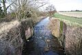
Keddington, where the church dates back to the 1100s and 1300s, was the site of Keddington Church Lock. Not much of it is left. Ticklepenny Lock is better preserved. It has four curved sections. A modern concrete bridge crosses over part of this lock. Nearby are the Grade I listed ruins of Louth Abbey, a Cistercian abbey from 1139.
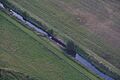
Willows Lock is also quite well preserved, similar to Ticklepenny Lock. Salter Fen Lock is also similar, but it has a large opening that acts as an overflow.
Between the canal and the River Lud is a sewage treatment plant. The cleaned water from the plant flows into the canal below the lock. Beyond that are Alvingham Fisheries and a bridge. Alvingham Lock has two drain openings in its western wall. Water from the River Lud flows under this lock to power Alvingham Mill.
The canal then passes St Mary's Church, which was once part of a priory. It dates from the 1000s to the 1300s and is Grade I listed. In the same churchyard is St Adelwold's Church, also Grade I listed. These churches separate Alvingham Water Mill from the canal. The current mill building was built in 1782. Most of its machinery, including an 11-foot (3.4 m) water wheel, is from 1782. Water from the mill flows back into the canal further downstream.

At High Bridge, the canal turns north. The River Lud continues northeast as the Old Eau. Outfen Lock was one of the locks with straight sides. Its western wall has fallen down, but the eastern wall remains. The land around here is very flat and has many drainage ditches.
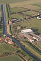
Water from Austen Fen is pumped into the canal by two pumping stations. These, and other pumping stations along the canal, are managed by the Lindsey Marsh Internal Drainage Board. The canal continues past Canal Farm and under Fen Bridge. On the east bank is a 19th-century warehouse.
Biergate East and West pumping stations are near Covenham Reservoir. This reservoir was built in the 1960s to provide drinking water. The water treatment plant is near Fire Beacon Farm and bridge. This bridge was the temporary end of the canal when it first opened.
Fulstow East and West pumping stations are close to Heelgate Farm. The only major road that crosses the canal is the A1031, at Thoresby Bridge. Near this bridge is another old warehouse, built in 1821. There is also Thoresby Bridge pumping station.
The last straight-sided lock was at Tetney, but nothing remains of it. It has been replaced by a sluice gate. The very end of the canal is now protected from high sea levels by a large sluice at Tetney Haven.
Images for kids
-
Aerial View at Austen Fen
-
Ticklepenny Lock
-
Willows Lock


Points of interest
| Point | Coordinates (Links to map resources) |
OS Grid Ref | Notes |
|---|---|---|---|
| Tetney Outfall Sluice | 53°30′28″N 0°02′26″E / 53.5079°N 0.0406°E | TA354031 | |
| Tetney Lock | 53°29′56″N 0°01′18″E / 53.4988°N 0.0218°E | TA342021 | |
| Thoresby Bridge | 53°28′38″N 0°00′41″E / 53.4773°N 0.0114°E | TF335997 | |
| Fire Beacon Bridge | 53°27′10″N 0°02′10″E / 53.4527°N 0.0362°E | TF353970 | |
| Out Fen Lock | 53°24′50″N 0°03′59″E / 53.4139°N 0.0665°E | TF374927 | |
| Alvingham Lock | 53°23′50″N 0°03′06″E / 53.3973°N 0.0518°E | TF365909 | |
| Salter Fen Lock | 53°23′32″N 0°02′29″E / 53.3921°N 0.0413°E | TF358903 | |
| Willows Lock | 53°23′03″N 0°01′57″E / 53.3843°N 0.0325°E | TF352894 | |
| Ticklepenny Lock | 53°22′48″N 0°01′43″E / 53.3799°N 0.0285°E | TF350889 | |
| Keddington Church Lock | 53°22′33″N 0°01′16″E / 53.3759°N 0.0212°E | TF345884 | |
| Top Lock | 53°22′24″N 0°00′45″E / 53.3733°N 0.0126°E | TF339881 | Tilting weir |
| Louth River Head | 53°22′18″N 0°00′32″E / 53.3716°N 0.0089°E | TF337879 | end of canal |
