Vale of Pickering facts for kids
The Vale of Pickering is a flat, low area of land in North Yorkshire, England. The River Derwent flows through it. This area is mostly countryside with small villages and market towns. People have lived here for a very long time, since the Mesolithic period. Today, farming is the main job, but light industry and tourism are becoming more important.
Contents
Where is the Vale of Pickering?
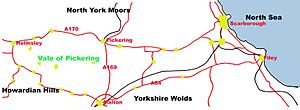
The Vale of Pickering is a flat area of land that runs from east to west. It has clear borders:
- To the south, you'll find the Yorkshire Wolds.
- To the north, there are the Corallian limestone hills of the North York Moors.
- The North Sea coast is to the east.
- The Howardian Hills are to the west.
Roads and Railways
Major roads like the A64 and A170 run east-west through the vale. These roads follow the old shoreline of a huge lake that formed here after the last ice age. The A169 road goes north-south, connecting the towns of Malton and Pickering. Near the coast, the A165 goes through Scarborough.
There are also train lines. A main line connects Malton to Scarborough. Another line links Scarborough to Filey and Bridlington along the coast. For fun, you can ride the North Yorkshire Moors Railway. This special heritage railway runs steam and old diesel trains from Pickering to Grosmont. You can even connect to Whitby from there!
Most of the Vale of Pickering is in the Ryedale District. A smaller part to the east is in the Scarborough District.
What is the Vale of Pickering Like?
Weather and Climate
Like the rest of the United Kingdom, the Vale of Pickering has cool summers and mild winters. The weather changes often, both daily and with the seasons. Strong westerly winds bring changeable, windy weather, especially in winter. Sometimes, high-pressure systems bring clear, fair weather. In winter, these can make it cold and dry. In summer, they often bring dry, settled conditions, which can sometimes lead to droughts.
The area is milder in winter and cooler in summer than other places at the same latitude. This is because of the Gulf Stream in the northern Atlantic Ocean.
Temperatures change throughout the day and year. Nights are usually cooler. January is the coldest month, with an average high of about 5.8 degrees Celsius. July is usually the warmest, with an average high of about 19.4 degrees Celsius. The area gets about 755 millimeters of rain each year, spread over about 129 days.
Rocks and Land
The Vale of Pickering used to be a large lake after the ice age. Today, it's mostly flat. The ground is covered by deposits left behind by glaciers. In the far east, there are some gently rolling hills made of clay and rocky mounds. The older rocks underneath, like Jurassic sandstones and mudstones, don't really shape the land much.
You can find some small areas of Jurassic limestone near the Howardian Hills and the North York Moors. There's also some chalk from the Wolds mixed with sand in the southeast. Springs, which are places where water comes out of the ground, can be found around the edges of the vale.
Rivers and Drainage
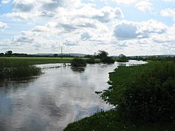
The Vale of Pickering acts like a big bowl that collects water from the surrounding hills. At the eastern end, the River Hertford flows west into the Derwent. The Derwent starts in the North York Moors, then flows south into the vale. In the western part, the River Rye and its many smaller streams flow east. They join the Derwent north of Malton.
The Derwent then flows south through Malton and a narrow valley called Kirkham gorge. Eventually, it joins the River Ouse. Many of the waterways in the Vale are looked after by the Vale of Pickering Internal Drainage Board. They help manage the water levels.
Plants and Animals
After the last ice age, the huge Lake Pickering slowly drained away. This left behind a network of rivers and marshy areas. Over time, people have drained these marshes and wet meadows. Now, the land has many canals and drainage ditches that control the water level.
Even with all this work to manage the water, the rivers of the Vale of Pickering are still very important for wildlife. You can find many kinds of water birds, plants, insects, and mammals living near the rivers. Fish like grayling and brown trout also live in the western rivers.
The deep, straight drainage ditches, which are often cleaned and can get dirty from farm runoff, are not great places for wildlife.
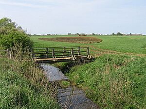
Draining the land has made the soil quite fertile. Farmers use it to grow crops and for grazing animals. The vale has flat open fields, areas where a lot of crops are grown, and more varied, hilly landscapes with enclosed fields. This mix makes the vale interesting. There aren't many woodlands, but you'll find more in the east near West Ayton and Wykeham.
The coastal area has a different look. This land was not part of the glacial Lake Pickering. Glacial deposits have made it more hilly and uneven. In all areas, farming has caused a loss of natural habitats. However, small parts of the original habitats are now being protected.
History of People in the Vale
People have lived in the Vale of Pickering since the Mesolithic period, which was a very long time ago.
Early Settlements
One of the most important early sites is Star Carr. Here, archaeologists found proof of a permanent house from 10,500 years ago. It was on the shore of a shallow lake. They also found a wooden platform built over the lake itself. Because the area was waterlogged, many old organic remains and flint tools survived. This is Britain's most famous Mesolithic site.
The Star Carr site was surrounded by birch trees. Some trees were cut down to build a rough platform of branches and brushwood. Then, lumps of turf and stones were placed on top to create a village. About four or five families probably visited this site. They hunted, fished, gathered wild plants, made tools and weapons, and prepared animal skins for clothes.
Near the southern edge of the vale is West Heslerton. Recent digs there show that people have lived in this spot continuously since the Late Mesolithic Age, around 5000 BC. This site has given us a lot of information about homes and daily life from the Neolithic period right up to today.
Later Periods
As farming developed in the Neolithic period, people built long burial mounds. Remains from the Bronze and Iron Age have been found around the edge of the vale. There are also parts of Roman roads and Roman villas, showing that people were busy with trade and farming during Roman times.
In 2011, digs near the village of Sherburn found the remains of a large Anglo-Saxon settlement.
The vale is full of history from the English medieval period (between the 11th and 15th centuries). You can see castles like those at Helmsley and Pickering. There are also fortified manor houses and old churches. A good example of medieval strip fields can be seen at Middleton.
In the 17th and 18th centuries, rich landowners built beautiful homes and estates. Examples include Wykeham Abbey, Nunnington Hall, and Ebberston Hall.
How Villages Are Placed
The way villages are spread out in the Vale of Pickering is interesting. There are two main types of settlements, both linked to the shape of the land:
- The first type includes villages and towns on the northern and southern edges of the area. These were built close to each other, often along the old shoreline of the glacial lake. They were placed where springs came out of the ground. Many of the areas around these villages stretch in long, narrow strips from the valley floor up to the higher ground. This meant each area had different types of soil and heights.
- The second type of settlement is on the valley floor itself. These are smaller villages, spaced further apart, and built on slightly higher ground. These villages appeared later, after the marshy lands were drained in the early 1800s. Long, narrow lanes and tracks with wide grassy edges connect these villages.
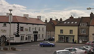
The buildings are made from local materials like soft limestones, sandstones, and harder gritstones. The steep roofs suggest that older buildings once had thatch coverings. However, most of these have now been replaced with red roof tiles.
Jobs and Economy
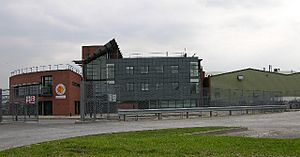
The market towns of Helmsley, Kirkbymoorside, Pickering, and Malton are the biggest towns in the Ryedale District. About half of the people in the district live in these towns. The eastern part of the area is also influenced by Scarborough.
Each market town in the Ryedale District has areas set aside for businesses. Small companies that do light manufacturing or offer services work here. The biggest employer in the district is the Malton Bacon Factory, which employs over 2,000 people. Most other businesses employ fewer than 25 people.
In the Scarborough Borough part of the Vale of Pickering, there's a small industrial area in Hunmanby. The main jobs in the vale are in farming. Tourism and shops in the market towns and near the coast also provide many jobs.
Fun Places to Visit
- Helmsley Castle - These are the ruins of a castle started after 1120.
- Nunnington Hall - A 17th-century manor house with a beautiful walled garden by the River Rye.
- Pickering Castle - A great example of an early castle that is well-preserved.
- Filey - A lovely coastal town.
- Flamingoland - A popular theme park and zoo.
- Malton - The largest market town in the vale. It has Roman beginnings and a museum with local archaeology.
 | Isaac Myers |
 | D. Hamilton Jackson |
 | A. Philip Randolph |


