
William Smith (geologist) facts for kids
Quick facts for kids
William Smith
|
|
|---|---|
.jpg)
William Smith in 1837
|
|
| Born | 23 March 1769 Churchill, Oxfordshire
|
| Died | 28 August 1839 (aged 70) Northampton, England
|
| Nationality | English |
| Known for | Geological map of England and Wales |
| Awards | Wollaston Medal (1831) |
| Scientific career | |
| Fields | Geology |
William 'Strata' Smith (born March 23, 1769 – died August 28, 1839) was an English geologist. He is famous for making the first detailed geological map of an entire country. This map showed the different types of rocks and land across England and Wales.
When his map first came out, many scientists didn't give him enough credit. This was partly because he didn't have a fancy education. He also faced money problems and even spent time in prison because of debt. But later in his life, people finally recognized his amazing work. He became known as the "Father of English Geology".
Contents
William Smith's Early Life
Smith was born in a small village called Churchill, Oxfordshire. His father was the village blacksmith. William's father died when he was only eight years old. His uncle, a farmer, then raised him and his brothers and sisters.
William taught himself a lot. He was very smart and loved to observe things. He read many books from a young age. He was also good at math and drawing. In 1787, he started working for Edward Webb, a land surveyor. William learned quickly and soon became very skilled at surveying.
In 1791, he went to Somerset to survey a large estate. He stayed there for eight years, working on projects like the Somerset Coal Canal. During this time, Smith looked closely at many coal mines. He saw and recorded the different layers of rock and coal. These studies, along with what he saw when canals were dug, helped him develop his ideas about how rock layers are formed.
Discovering Rock Layers

Smith worked at a coal mine called Mearns Pit. Here, he noticed that the rock layers, called strata, were always in the same order. He realized that each layer could be identified by the fossils found inside it. The same types of fossils appeared in the same order in rocks all over England.
He also saw that the rock layers tilted slightly towards the east. This gave him an idea he called "The Principle of Faunal Succession." This idea meant that specific groups of fossils follow each other in a predictable order through rock layers. He wanted to see if this pattern was true everywhere.
As he traveled for work, Smith kept collecting rock samples. He mapped where different rock layers were found. He also drew pictures of how the layers looked underground. This is how he earned the nickname "Strata Smith." He collected many valuable fossils from places like canals, roads, railway cuttings, and quarries. He also found ways to identify deposits of Fuller's earth, a type of clay.

Smith shared his discoveries in books with many pictures of his fossils. This helped other scientists study how fossils were spread out and test his ideas. His fossil collection was especially good for Jurassic fossils. These included many types of brachiopods, ammonites, and molluscs. These creatures lived in shallow seas long ago. Some of the names he gave to rock formations, like "Cornbrash," are still used today.
Creating the First Geological Map

In 1799, Smith made his first large map of the rocks around Bath. Before this, he only knew how to draw the layers vertically (up and down). But he saw a map that showed different soil types around Bath using colors. He used this idea to draw his own geological map.
He chose a few rock types and gave each a different color. Then he drew the boundaries of where each rock type appeared. He colored them in, creating a basic geological map.

In 1801, Smith drew a rough sketch of what would become the first geological map of most of Great Britain. He traveled widely, working as a surveyor. This allowed him to meet important people. In 1815, he published his famous geological map. It covered all of England and Wales and parts of Scotland.
This wasn't the world's first geological map, but it was the first to cover such a large area in great detail. It was also one of the first to use fossils to identify rock layers. The map used symbols for canals, tunnels, roads, and mines. Different rock types were shown with different colors, painted by hand. Even today, Smith's map looks very similar to modern geological maps of England.
He also included a "Sketch of the succession of STRATA and their relative Altitudes." This was a drawing showing how the rock layers looked underground. This was a new way to show how the land's shape was connected to the rocks beneath it. He also published another book, Strata Identified by Organized Fossils, which explained how specific fossils could be used to match rocks in different areas.

Smith's projects and investments led to money problems. He tried to sell his fossil collection to the British Museum for £700, but it wasn't enough to cover his debts. Because of this, Smith was sent to a debtors' prison in 1819.
After being released from prison, Smith found that his home and belongings had been taken. He worked as a traveling surveyor for many years. Eventually, one of his employers, Sir John Johnstone, recognized his talent. He helped Smith get the respect he deserved. Smith then worked as a land manager for an estate near Scarborough. He also helped design the Rotunda Museum, a geology museum in Scarborough. He created its unique round shape and how the fossils were displayed.
Later Recognition and Legacy

It wasn't until February 1831 that the Geological Society of London finally honored Smith. They gave him the first Wollaston Medal for his great work. At this event, the president of the society called Smith "the Father of English Geology." That same year, King William IV gave Smith a yearly payment of £100.
In 1835, Smith received an honorary Doctorate of Laws degree from Trinity College Dublin. In 1838, he was chosen to help pick the stone for the new Palace of Westminster. He died in Northampton and is buried near St Peter's Church, Northampton.
Modern geological maps are still based on Smith's original work. Several copies of his map still exist today. One is on display at the Geological Society of London, where the public can see it.
Smith's work had a lasting impact:
- His map was the first detailed geological map of Great Britain. It became the basis for all future maps.
- Geological surveys around the world use ideas from his work.
- His nephew, John Phillips, lived with William Smith as a young man and learned from him. John Phillips became a very important geologist himself. He helped create the geological time scale we use today.
- A crater on Mars is named after William Smith.
- The Geological Society of London holds a special lecture each year in his honor.
- In 2005, the Natural History Museum created a character based on William Smith to interact with visitors.
- His work was an important foundation for the ideas of Charles Darwin.
- The Rotunda Museum in Scarborough was reopened in 2008 as 'Rotunda – The William Smith Museum of Geology'.
- A building at Keele University is named after two William Smiths. One is the subject of this article, and the other was an earlier mapmaker.
See also
 In Spanish: William Smith (geólogo) para niños
- The Map that Changed the World, a book about Smith by Simon Winchester
- Geology of Great Britain
- William Maclure
- George Bellas Greenough
Images for kids
-
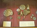
William Smith's fossil collection on display at the British Museum.

