
River Tillingbourne facts for kids
Quick facts for kids Tillingbourne |
|
|---|---|

River Tillingbourne running through the Albury estate
|
|
| Country | England |
| County | Surrey |
| Districts | Mole Valley District, Guildford Borough |
| Physical characteristics | |
| Main source | Tilling Springs Leith Hill, Surrey |
| Length | 24 km (15 mi) |
| Basin features | |
| Tributaries |
|
The River Tillingbourne (also known as the Tilling Bourne) is a river in Surrey, England. It flows along the south side of the North Downs hills and eventually joins the River Wey near Guildford. The river starts from springs south of Leith Hill and travels about 24 km (15 mi). It passes through villages like Friday Street, Abinger Hammer, Shere, Albury, and Chilworth. The area where the river begins is natural and mostly uninhabited.
Contents
River's Journey: Geography and Flow
The Tillingbourne river first flows north for about 4 km (2.5 mi) from Leith Hill. It goes over small waterfalls and weirs. Then, it turns west and flows for 14 km (8.7 mi) through places like Abinger Hammer and Chilworth. Finally, it reaches the River Wey at Shalford.
The river's path is special because it follows the direction of softer rock layers. This type of river is called a subsequent stream.
Tributaries: Streams Joining the Tillingbourne
The Tillingbourne has four main streams that flow into it. The Friday Street stream joins near Wotton House. The Holmbury St Mary stream meets the river at Abinger Hammer. The Sherbourne Brook drains the Silent Pool and Sherbourne Pond. Lastly, the Law Brook joins the Tillingbourne near Postford.
River's Role in History: Industry and Mills
From the 1600s to the mid-1900s, the Tillingbourne valley was an important industrial area. This was because it was close to London and goods could be easily moved using the River Wey and the Thames. The river's flowing water was used to power many mills.
About 24 mill sites have been found along the river. These mills were used for many different things. They made gunpowder, paper (even for bank-notes!), and worked with iron and wire. They also helped with fulling cloth, tanning leather, and pumping water. Of course, there were also mills for grinding flour, grain, and malt. Some of the first gunpowder mills were set up in 1626 by The East India Company at Chilworth.
In 1676, a famous diarist named John Evelyn wrote about the river. He was amazed by "such Variety of Mills and Works upon so narrow a Brook." He saw mills for corn, cloth, brass, iron, and gunpowder.
Modern Uses of the River
Today, the river is still used for various purposes. There is a trout farm, and places that grow watercress and reeds. There is even a gin distillery that uses the river's resources.
The river flows through the Albury estate, which has fishing spots for fun. These are called Weston fishery, Vale End fishery, and Powder Mills fishery. The river's natural path was changed a little here to fit the estate's needs.
Near where the Tillingbourne joins the Wey, there is a pumping station at Shalford. It provides a lot of water every day (between 4 and 7 million gallons) to supply towns like Godalming and parts of Guildford.
Famous Mills Along the River
Many mills once stood along the Tillingbourne and its smaller streams. Some notable ones include:
- Abinger Hammer Mill
- Gomshall Mill, which is now a pub
- Netley Mill, also known as Shere Mill
- Albury Park Mill
- Chilworth Gunpowder Mills, which were divided into Lower, Middle, and Upper Works.
- Shalford Mill, which is now looked after by the National Trust.
River's Health: Environment and Water Quality
_by_Lewis_Pinhorn_Wood.jpg)
The River Tillingbourne is home to different types of fish, including wild brown trout and other coarse fish. The Environment Agency works with local fishermen to make the river a better home for these fish. They do this by creating areas with fast-flowing water and calm pools, and by trimming plants that hang over the river.
An unwanted guest in the river is the signal crayfish, which is an invasive species. Students from nearby field studies centers often visit the river to study its environment. There are also ongoing issues with invasive plants. These plants grow too much because of extra nutrients from waste-water treatment and farm run-off.
The Victorian painter, Lewis Pinhorn Wood, loved the Tillingbourne. He lived in Shere from 1884 to 1897 and painted many scenes along its banks. His paintings include The Silent Pool and Evening on the Tillingbourne.
Understanding Water Quality
The Environment Agency checks the water quality of rivers in England. They give each river an overall ecological status, which can be high, good, moderate, poor, or bad. This status looks at things like the number and types of invertebrates (small creatures without backbones), plants, and fish. They also check the chemical status, which compares chemical levels to safe limits. This is rated as good or fail.
In 2022, the water quality of the Tillingbourne was:
| Section | Ecological Status |
Chemical Status |
Length | Catchment | Channel |
|---|---|---|---|---|---|
| Tillingbourne | Moderate | Fail | 24.122 km (14.989 mi) | 58.931 km2 (22.753 sq mi) |
A "moderate" ecological status means the river's ecosystem is okay, but could be better. A "fail" chemical status means that some chemicals in the water are above safe levels.
Other Interesting Places Along the Tillingbourne
- Tillingbourne Waterfall is a beautiful spot.
- Newlands Corner offers amazing views over the entire valley.
- Silent Pool is a mysterious and calm lake.
- St Martha's Hill above Chilworth also gives a wide view of the valley.
Images for kids
-
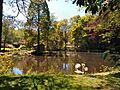
Pond at Tilling Springs, where the river begins.
-
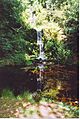
Tilling Waterfall, a lovely cascade in the upper valley.
-

A wide view of the Tillingbourne valley from St Martha's Hill.


