Law Brook, Surrey facts for kids
Quick facts for kids Law Brook |
|
|---|---|

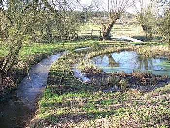
Law Brook flowing westwards from the hamlet of Brook towards Postford
|
|
| Other name(s) | Postford Brook |
| Country | England |
| County | Surrey |
| Borough | Guildford Borough |
| Physical characteristics | |
| Main source | Gasson Farm, The Hurtwood and sources in Peaslake proper Peaslake, Shere, Borough of Guildford 148 m (486 ft) 51°11′02″N 0°26′38″W / 51.18389°N 0.44389°W |
| River mouth | River Tillingbourne Colyers Hanger, Albury (foot), Borough of Guildford 50 m (160 ft) 51°13′20″N 0°31′00″W / 51.22222°N 0.51667°W |
| Length | 7 km (4.3 mi) |
| Basin features | |
| Progression | Postford/Law Brook—Tillingbourne—River Wey—River Thames |
| River system | Thames Basin |
The Law Brook, also known as Postford Brook, is a small river in Surrey, England. It flows through the beautiful Surrey Hills AONB (Area of Outstanding Natural Beauty). This brook is a tributary, meaning it feeds into a larger river. The Law Brook joins the River Tillingbourne, which then flows into the River Wey. Finally, the River Wey joins the famous River Thames.
The Law Brook is special because of its history. Many years ago, people used its water power for different industries. You can still find signs of these old industrial sites along its banks.
Contents
What is the Course of Law Brook?
The Law Brook flows for about 7 kilometers (about 4.3 miles). It starts by flowing west-northwest, then turns north. Its journey takes it through an area called the Vale of Holmesdale. This is a geological term for a valley that stretches across parts of England.
Where Does the Law Brook Begin?
The brook mainly starts in the area of Peaslake. This is a small village with old farm lands and common land, which is land that everyone in the community could use. The source of the brook is on the northern slopes of the Greensand Ridge, a line of hills.
The upper part of the brook's journey is mostly through forests like Winterfold Forest and Hurtwood. There are also some pastures (fields for grazing animals). The brook helps drain water from these areas.
What Villages Does the Brook Pass Through?
As the Law Brook flows, it provides water to the village of Brook (also known as Little London) in Albury. A "clustered village" means the houses are built close together.
On its left side, after many smaller streams join to form the main brook, it passes the northern parts of Farley Green. This is another village in the Albury area. It also briefly touches a small part of Blackheath, which is a wooded plateau. On the opposite bank, it passes fields belonging to Albury's main settlement, including where an old millhouse once stood.
How Was the Brook Used for Industry?
The last 500 meters (about 550 yards) of the Law Brook marks the boundary between the land of Albury and St Martha, near Chilworth. Both the Law Brook and the River Tillingbourne were very important for industry in the past.
People built special narrow channels called "leats" and created mill ponds. These were used to power industrial mills. One famous example was the Royal Gunpowder Mills. A long leat was dug to divide Chilworth and supply its largest pond, which is now known as The Fish Pond. This shows how people "harnessed" or used the power of the water.
What Else is Near the Brook?
The North Downs Line, which is a railway line, runs alongside the Law Brook for about 1.8 kilometers (about 1.1 miles). It follows the distant right bank of the brook through the Albury area.
 | Selma Burke |
 | Pauline Powell Burns |
 | Frederick J. Brown |
 | Robert Blackburn |

