Cranleigh Waters facts for kids
Quick facts for kids Cranleigh Waters |
|
|---|---|

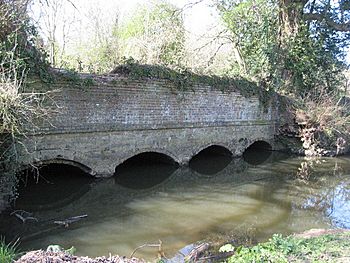
Ruins of Gosden Aqueduct which carried the
Wey and Arun Canal over Cranleigh Waters. |
|
| Other name(s) | Bramley Wey |
| Country | England |
| County | Surrey |
| Districts | Guildford, Waverley Mole Valley (unnamed tributaries only) |
| Physical characteristics | |
| Main source | Walliswood, Surrey, England 45 m (148 ft) 51°8′14″N 0°24′51″W / 51.13722°N 0.41417°W |
| River mouth | River Wey Shalford |
| Basin features | |
| Tributaries |
|
The Cranleigh Waters or Bramley Wey is a river in Surrey, England. It's a smaller river that eventually flows into the River Wey.
Contents
Where the River Flows
The Cranleigh Waters starts in the countryside north of Cranleigh. It begins near two other small streams, the Thornhurst Brook and Coneyhurst Gill. These streams first flow southwest towards a place called Vachery Pond.
After Vachery Pond, the Cranleigh Waters turns and flows north. It forms the border between the villages of Wonersh and Bramley. Finally, it joins the River Wey near Shalford.
A very old canal, the Wey and Arun Canal, runs alongside the Cranleigh Waters for much of its journey. This canal is no longer used. It crosses over the river at a place called Gosden Aqueduct, which is now in ruins.
Other Streams Joining the River
Many smaller streams, called tributaries, flow into the Cranleigh Waters. They add to its water flow.
Cobblers Brook
The Cobblers Brook also starts in the Greensand Ridge area. It begins as three small streams in the north of Ewhurst. This brook drains all the water from that area. It then flows west through the Baynards Park estate in Cranleigh before joining the Cranleigh Waters at Vachery Pond.
Streams from Walliswood
There are also three unnamed streams in the Walliswood area. These streams drain a small part of the Abinger parish. They flow into the Cobblers Brook in the southern part of Ewhurst.
Other Tributaries
Several other streams join the Cranleigh Waters from its left side (if you're looking downstream). These include Birtley Brook, Ridings Brook, North Brook, Great Brook, Scotsland Brook, Cold Bourne, and Nore Brook (also known as Smithbrook). These streams are shorter than the ones joining from the right side. They collect water from parts of Dunsfold and almost all of the Bramley area.
How Clean is the Water?
The Environment Agency checks the water quality of rivers in England. They give each river system an overall "ecological status." This status can be high, good, moderate, poor, or bad.
To figure out the ecological status, they look at different things. They check the types and numbers of tiny creatures like invertebrates, plants like angiosperms, and fish living in the river. They also check the "chemical status." This means they measure how much of different chemicals are in the water and compare them to safe levels. Chemical status is either rated "good" or "fail."
Here's how the Cranleigh Waters' water quality was rated in 2019:
| Section | Ecological Status |
Chemical Status |
Overall Status |
Length | Catchment | Channel |
|---|---|---|---|---|---|---|
| Cranleigh Waters | Moderate | Fail | Moderate | 28.873 km (17.941 mi) | 110.989 km2 (42.853 sq mi) |
- Ecological Status: "Moderate" means the river's ecosystem is not as healthy as it could be. It's somewhere in the middle.
- Chemical Status: "Fail" means that some chemicals in the water are above safe levels. This can be harmful to the river's plants and animals.
- Overall Status: "Moderate" is the final rating, showing there's room for improvement in the river's health.
 | Frances Mary Albrier |
 | Whitney Young |
 | Muhammad Ali |

