Nogoa River facts for kids
Quick facts for kids Nogoa |
|
|---|---|

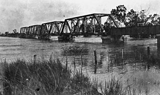
Railway bridge in Emerald during a flood, 1918
|
|
|
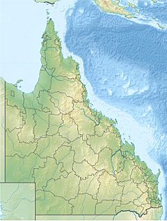
Location of Nogoa River mouth in Queensland
|
|
| Country | Australia |
| State | Queensland |
| Region | Central Queensland |
| City | Emerald |
| Physical characteristics | |
| Main source | Carnarvon Range Carnarvon National Park 501 m (1,644 ft) 24°51′38″S 147°00′16″E / 24.86056°S 147.00444°E |
| River mouth | confluence with Comet River, forming the Mackenzie River north of Comet 144 m (472 ft) 23°33′21″S 148°32′11″E / 23.55583°S 148.53639°E |
| Length | 569 km (354 mi) |
| Basin features | |
| River system | Fitzroy River basin |
| Basin size | 27,690 km2 (10,690 sq mi) |
| National parks | Carnarvon National Park, Minerva Hills National Park, Peak Range National Park, Snake Range National Park |
The Nogoa River is an important river in Central Queensland, Australia. It flows through beautiful landscapes and plays a big role in the local area.
Contents
River Journey and Features
The Nogoa River starts high up in the Carnarvon Range. This area is part of the Great Dividing Range and is found inside the Carnarvon National Park. From there, the river flows mostly towards the northeast, heading towards the town of Emerald.
As it travels, the Nogoa River is joined by 29 smaller streams, called tributaries. These smaller rivers add their water to the Nogoa. North of Comet, the Nogoa River meets the Comet River. When two rivers meet like this, it's called a confluence. After they join, they form a new, larger river called the Mackenzie River.
The Nogoa River drops about 361 meters (1,184 feet) over its entire length of 569 kilometers (354 miles). The Gregory Highway and Capricorn Highway both cross the river near Emerald.
River's Catchment Area
The Nogoa River has a large catchment area of 27,690 square kilometers (10,690 square miles). A catchment area is all the land where rain collects and drains into a particular river. This area includes parts of several national parks, such as Minerva Hills National Park, Peak Range National Park, and Snake Range National Park. About 271 square kilometers (105 square miles) of this area are wetlands, which are areas of land covered by water.
Fairbairn Dam and Water Use
The Fairbairn Dam was built on the Nogoa River in 1972. This dam created a huge reservoir called Lake Maraboon, which is Queensland's second-largest dam. The water from Lake Maraboon is sent through a system of channels along the Nogoa River. This water is used to irrigate, or water, farms in the Emerald Irrigation Area, helping crops grow.
European Discovery
The first European explorer to find the Nogoa River was Sir Thomas Mitchell. He discovered the river on July 19, 1846.
Major Flooding Events
The Nogoa River has experienced some very large floods over the years.
2008 Flood
In January 2008, the Nogoa River reached record-breaking flood levels. The water in the Fairbairn Dam quickly went over 100% capacity. Within a week, the floods caused big problems for farmers and residents in Emerald. The river broke its banks, and more than 2,500 people had to leave their homes.
The Nogoa River peaked at 15.4 meters (50.5 feet) in Emerald on the night of January 22, 2008. The floods also washed through the Ensham coal mine, stopping work in some parts and damaging large mining equipment.
2010-2011 Floods
The river was also affected by major flooding in December 2010 and January 2011. These floods impacted Emerald and the upper parts of the Nogoa's catchment area.
Cultural Heritage
The traditional owners of the land around the Nogoa River are the Gayiri people. They have lived in this area for tens of thousands of years, long before Europeans arrived in the 1800s. The Gayiri (also known as Kairi or Khararya) language region covers the land of the Central Highlands Regional Council, including Emerald and the Nogoa River.
 | Georgia Louise Harris Brown |
 | Julian Abele |
 | Norma Merrick Sklarek |
 | William Sidney Pittman |


