
Emerald, Queensland facts for kids
Quick facts for kids EmeraldQueensland |
|||||||||||||||
|---|---|---|---|---|---|---|---|---|---|---|---|---|---|---|---|

Emerald railway station, 2016
|
|||||||||||||||

Emerald
Location in Queensland
|
|||||||||||||||
| Population | 14,904 (2021 census) | ||||||||||||||
| • Density | 24.3888/km2 (63.167/sq mi) | ||||||||||||||
| Established | 1879 | ||||||||||||||
| Postcode(s) | 4720 | ||||||||||||||
| Elevation | 189 m (620 ft) | ||||||||||||||
| Area | 611.1 km2 (235.9 sq mi) | ||||||||||||||
| Time zone | AEST (UTC+10:00) | ||||||||||||||
| Location |
|
||||||||||||||
| LGA(s) | Central Highlands Region | ||||||||||||||
| State electorate(s) | Gregory | ||||||||||||||
| Federal Division(s) | Flynn | ||||||||||||||
|
|||||||||||||||
|
|||||||||||||||
Emerald is a town in the Central Highlands Region of Queensland, Australia. It is the main town for the Central Highlands Regional Council.
In 2021, about 14,904 people lived in Emerald.
Contents
Discovering Emerald's Past
Early History and Naming
The Gayiri people are the traditional owners of the land around Emerald. They have lived here for thousands of years. The Gayiri language covers this area, including the Nogoa River.
An explorer named Ludwig Leichhardt was the first European to visit the area between 1843 and 1845. Queensland became a British Colony in 1859.
The town of Emerald got its name from a large farm called Emerald Downs. This name was chosen around 1860. Some people think it was named after the green emerald gemstone. Others believe it was named for the bright green grass in the area.
Growth of the Town
Emerald was officially started in 1879. It became a key spot for building the Central railway line from Rockhampton. The first Post Office opened on 5 June 1879.
Emerald State School opened on 3 November 1879. Over the years, more schools were built. St Patrick's Catholic School started in 1902. Emerald North State School opened in 1980. The Capricornia School of Distance Education began in 1993. Marist College opened in 1996, and Denison State School in 1997. Emerald Christian College started in 2001.
In 1994, a new Emerald Library building was opened. The visitor information centre opened in 2005. St Brigid's Catholic Primary School was established in 2014. Ontrack School, which helps students who have left regular schools, opened in 2018.
In 1999, a giant artwork called the Big Easel was put up in Emerald. It's part of a worldwide art project.
Changing Boundaries
In 2020, the Queensland Government changed the local area boundaries. Emerald's area grew from 611.1 square kilometres to 844.9 square kilometres. This change helped to create new localities nearby.
Emerald's Location and Weather
Where is Emerald?
Emerald is located on the Nogoa River, which flows into the Fitzroy River. It's about 270 kilometres (168 miles) west of the coast and the city of Rockhampton. The town is where the Capricorn Highway and Gregory Highway meet. Emerald is also about 10 kilometres (6 miles) south of the Tropic of Capricorn.
Emerald's Climate
Emerald has a hot, dry climate with very hot summers. Summers are also quite wet. Winters are mild and dry, with cool nights. The hottest month is usually January, with average high temperatures around 34.6°C (94.3°F). July is the coolest month, with average highs around 23.4°C (74.1°F).
The town gets about 559 millimetres (22 inches) of rain each year. Most of this rain falls during summer. The highest temperature ever recorded was 46.2°C (115.2°F) in December 1919. The lowest was -5.6°C (21.9°F) in July 1899.
Flooding in Emerald
Emerald has experienced many floods over the years. Before the 1990s, floods mostly cut off parts of the town. Caravans in a local park would be moved to higher ground when the river rose.
The Fairbairn Dam is near Emerald. In January 2008, the dam overflowed for the first time in 17 years. A few days later, the Nogoa River flooded Emerald. About 1,000 houses were affected, and over 2,500 people had to leave their homes.
People of Emerald
In 2021, Emerald had a population of 14,906 people. About 5% of the people were Aboriginal and Torres Strait Islander. Most people (77%) were born in Australia. Other common birthplaces included New Zealand (4%), the Philippines (1.7%), South Africa (1.4%), and England (1.1%).
About 83% of people spoke only English at home. Other languages spoken included Afrikaans and Tongan. Many people (36.9%) said they had no religion. The next largest groups were Catholic (21.8%) and Anglican (10.6%).
Important Places in Emerald
Emerald has some places that are important to its history. These are called heritage-listed sites.
- Emerald railway station, on Clermont Street.
Emerald's Economy
Emerald is a service town for many industries in the area.
- Mining: There are large coal mining operations nearby, including the Kestrel, Gregory, and Ensham mines.
- Agriculture: Farmers in the area grow cotton, grapes, citrus fruits, and grains. The cotton is processed at the Yamala Cotton Gin.
- Energy: The Emerald Solar Park is just west of town. It creates up to 74 megawatts of electricity from the sun.
In the past, the citrus fruit industry was badly affected by a plant disease called citrus canker. This started in 2004, and over half a million citrus trees had to be destroyed. The disease was declared over in 2009.
Learning in Emerald
Emerald has many schools for students of all ages.
- Emerald State School: A government primary school (Prep to Year 6) on Anakie Street.
- Emerald North State School: Another government primary school (Early Childhood to Year 6) on Campbell Street. It has a special education program.
- Denison State School: A government primary school (Prep to Year 6) on Gray Street. It also has a special education program.
- Capricornia School of Distance Education: A government school (Early Childhood to Year 12) for students who learn from home. It's on the corner of Gray and Gladstone Streets and shares a campus with Denison State School.
- Emerald State High School: A government secondary school (Years 7–12) on Old Airport Drive. It has a special education program.
- St Patrick's Catholic Primary School: A Catholic primary school (Prep to Year 6) on Yamala Street.
- St Brigid's Catholic Primary School: A Catholic primary school (Prep to Year 6) on Gregory Highway.
- Marist College Emerald: A Catholic secondary school (Years 7–12) on Jeppesen Drive.
- Emerald Christian College: A private school (Prep to Year 12) on Gregory Highway.
- Ontrack: A private school (Years 5–10) on Borilla Street. It helps students who have struggled in regular schools.
Central Queensland University also has a campus in Emerald, offering higher education.
Community Places in Emerald
- Emerald Library: Run by the Central Highlands Regional Council at 44 Borilla Street.
- Queensland Country Women's Association (QCWA): The Emerald branch meets at 45 Borilla Street.
- Emerald Uniting Church: Located at 49 Yamala Street.
- Calvary Christian Church: Found at 11 Gladstone Street.
Fun Things to See and Do

- The Gemfields: West of Emerald, you'll find areas like Sapphire and Rubyvale. These places are famous for their sapphires, which are the largest sapphire fields in the Southern Hemisphere!
- Fairbairn Dam and Lake Maraboon: A short drive south of town, the Fairbairn Dam was built in 1972. It creates Lake Maraboon, one of Australia's largest artificial lakes. The lake can hold three times more water than Sydney Harbour! It's great for water sports and helps the cotton farms grow.
- The Big Easel:

This huge artwork was put up in 1999 in Moreton Park. It's a 25-metre (82-foot) tall painting of Vincent van Gogh's sunflowers. It's one of seven such artworks around the world by artist Cameron Cross. Emerald was chosen because it's a big sunflower-growing area and has a sunflower festival. It's considered one of Australia's Big Things.
Emerald Events
Emerald holds an annual sunflower festival. This fun event takes place in the week before Easter.
Media in Emerald
Newspapers
Emerald Today is the local newspaper. It comes out every Friday and shares news and sports from the Emerald area.
Radio
Emerald has a few radio stations:
- 4HI: This is the oldest local radio station, starting in 1981. It has local breakfast and drive shows.
- Hot FM: This station plays music for young people. Its programs come from other towns, like Gladstone.
- ABC Capricornia: This is the local ABC station. Its programs are broadcast from Rockhampton.
- 4EEE: This is a local community radio station.
Television
Emerald gets all its TV channels from Rockhampton. This means you can watch local news bulletins like Seven News and WIN News, which sometimes include news from the Central Highlands region.
Sports in Emerald
The most popular sport in Emerald is rugby league. The town has two teams, the Emerald Tigers and the Emerald Brothers. They both play in the Central Highlands Rugby League competition.
Famous People from Emerald
- Ethan Bullemor, an Australian rugby league player
- Damian Gibson, an Australian rugby league player
- Mitchell Langerak, an Australian footballer
- Alan McIndoe, an Australian rugby league player
Images for kids
-
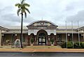
Emerald railway station, 2016
-
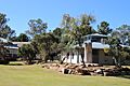
Visitor information centre, Emerald, 2017
-
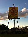
The Big Easel, 2012
See also
 In Spanish: Emerald para niños
