Gindie facts for kids
Quick facts for kids GindieQueensland |
|||||||||||||||
|---|---|---|---|---|---|---|---|---|---|---|---|---|---|---|---|

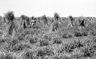
Sudan grass in stook, State Farm, Gindie, circa 1933
|
|||||||||||||||
| Population | 232 (2021 census) | ||||||||||||||
| • Density | 0.1737/km2 (0.450/sq mi) | ||||||||||||||
| Postcode(s) | 4702 | ||||||||||||||
| Area | 1,335.3 km2 (515.6 sq mi) | ||||||||||||||
| Time zone | AEST (UTC+10:00) | ||||||||||||||
| LGA(s) | Central Highlands Region | ||||||||||||||
| State electorate(s) | Gregory | ||||||||||||||
| Federal Division(s) | Flynn | ||||||||||||||
|
|||||||||||||||
Gindie is a small countryside area in Queensland, Australia. It is part of the Central Highlands Region. In 2021, about 232 people lived there.
Contents
Discovering Gindie's Geography
Gindie is a rural area with wide-open spaces. A small community called Fernlees is located in the southern part of Gindie.
The main road, called the Gregory Highway, goes right through Gindie. It connects Emerald in the north to Minerva in the south. The highway also passes through Fernlees. Next to the highway, you'll find the Blackwater railway line. There's a special stop for trains called a railway siding in Fernlees.
Gindie's Past: A Look at History
The name Gindie means "much brigalow". Brigalow is a type of tree found in Australia.
Early Schools and Farms
Gindie Provisional School first opened its doors on 12 November 1897. It later became Gindie State School on 1 January 1909. The school closed for a while in 1949 but then reopened.
In 1898, the Gindie State Farm was set up. This farm was used to try growing new types of crops in the area. Farmers experimented with plants like sorghum, maize, and pumpkins. The farm operated until 1932.
Another school, Fernlees State School, opened on 20 September 1951. However, it only stayed open for a short time, closing in 1953.
Changes to Boundaries
On 17 April 2020, the Queensland Government made some changes to the local boundaries in the Central Highlands Region. They created three new areas: Rubyvale, Sapphire Central, and Anakie Siding.
Because of these changes, Gindie's boundaries were also adjusted. Gindie gained some land from the former area of The Gemfields and from Lochington. However, it lost a small part of its northern area to Anakie Siding. These changes made Gindie a bit bigger, growing from about 1293.4 square kilometres to 1335.3 square kilometres. As a result, Lake Maraboon is now completely inside the north-west part of Gindie.
Who Lives in Gindie?
The number of people living in Gindie has changed over the years:
- In 2011, there were 382 people.
- In 2016, the population was 209 people.
- In 2021, the population increased slightly to 232 people.
Learning in Gindie
Gindie has a primary school and an outdoor education centre.
Gindie State School
Gindie State School is a government primary school for students from Prep (the first year of school) to Year 6. It is located at the corner of Old Cullen-la-ringo Road and the Gregory Highway. In 2018, the school had 35 students. There were 4 teachers and 8 other staff members helping out.
Camp Fairbairn Outdoor Education Centre
Camp Fairbairn Outdoor Education Centre is a special place for outdoor learning. It is located at Fairbairn Dam. The centre has a principal, 3 teachers, and 3 other staff members. It offers places for students to stay overnight and provides outdoor activities for kids from Prep all the way up to Year 12.
Secondary Education
There isn't a high school directly in Gindie. Most students who want to go to secondary school travel to Emerald. The nearest high school is Emerald State High School, which is located north of Gindie.
 | William M. Jackson |
 | Juan E. Gilbert |
 | Neil deGrasse Tyson |


