
Mitchell, Queensland facts for kids
Quick facts for kids MitchellQueensland |
|||||||||||||||
|---|---|---|---|---|---|---|---|---|---|---|---|---|---|---|---|

Looking downstream on the Maranoa River on the eastern side of Mitchell
|
|||||||||||||||

Mitchell
Location in Queensland
|
|||||||||||||||
| Population | 995 (2021 census) | ||||||||||||||
| • Density | 1.6504/km2 (4.275/sq mi) | ||||||||||||||
| Established | 1864 | ||||||||||||||
| Postcode(s) | 4465 | ||||||||||||||
| Elevation | 336.3 m (1,103 ft) | ||||||||||||||
| Area | 602.9 km2 (232.8 sq mi) | ||||||||||||||
| Time zone | AEST (UTC+10:00) | ||||||||||||||
| Location |
|
||||||||||||||
| LGA(s) | Maranoa Region | ||||||||||||||
| County | Dublin | ||||||||||||||
| State electorate(s) | Warrego | ||||||||||||||
| Federal Division(s) | Maranoa | ||||||||||||||
|
|||||||||||||||
|
|||||||||||||||
Welcome to Mitchell, a small town in the Maranoa Region of Queensland, Australia! It's a rural place that helps support the surrounding farms, especially those raising cattle and sheep. In 2021, about 995 people lived in Mitchell.
Contents
- Exploring Mitchell's Location
- Mitchell's Past: A Journey Through Time
- People Living in Mitchell
- Preserving History: Heritage Sites
- Community Life and Services
- Learning in Mitchell: Schools
- Essential Facilities in Mitchell
- Media and Entertainment
- Mitchell's Climate
- Fun Things to Do in Mitchell
- Famous People from Mitchell
- Images for kids
Exploring Mitchell's Location
Mitchell is located on the Warrego Highway, a major road in Queensland. It's about 587 kilometers (365 miles) west of Brisbane, the capital city. If you travel east, you'll find Charleville about 176 kilometers (109 miles) away. The Warrego Highway actually becomes Cambridge Street, the main street of Mitchell, as it passes through town.
The Maranoa River is an important natural feature here. It flows around the northern and eastern sides of Mitchell. This river eventually joins the Balonne River, which is part of a larger river system.
Mitchell's Past: A Journey Through Time
Early Inhabitants: Mandandanji and Gunggari Peoples
Long before European settlers arrived, the land around Mitchell was home to the Mandandanji and Gunggari Aboriginal peoples. Scientists have found evidence from archaeological digs in the Mount Moffatt area that shows Aboriginal people lived here for about 19,500 years! Today, many descendants of these original peoples still live in or visit the area.
How Mitchell Got Its Name
The town of Mitchell is named after Sir Thomas Mitchell. He was a famous explorer and Surveyor General of New South Wales. Sir Thomas Mitchell explored this area back in 1846.
From Homestead to Hotel
In 1854, a man named Edmund Morey started a property called Mitchell Downs. Later, in 1864, a big flood badly damaged the original homestead. Thomas Close then bought the ruins of the building and turned it into the Maranoa Hotel. The first post office, called Mitchell Downs Post Office, opened on January 1, 1865. It was later renamed Mitchell Post Office around 1878.
The Kenniff Brothers' Capture
In 1902, two famous bushrangers, Patrick and James Kenniff, were captured south of Mitchell. This happened after a short stand-off at a place now known as Arrest Creek. James Kenniff was released after 12 years in prison and lived a peaceful life until 1940.
Mitchell's Changing Administration
Mitchell used to be the main administrative center for the Shire of Booringa local government area. However, since 2008, the town has become part of the larger Maranoa Region.
People Living in Mitchell
In 2021, the town of Mitchell had a population of 995 people. This number helps us understand how many people call Mitchell home.
Preserving History: Heritage Sites

Mitchell has some important places that are protected because of their history. These are called heritage-listed sites. They include:
- The Mitchell War Memorial on Cambridge Street, which honors those who served in wars.
- The Mitchell railway station on Oxford Street, which includes the passenger station, a goods shed used by companies like Watco Australia and Aurizon, and the old station master's building on Sheffield Street.
Community Life and Services


Mitchell offers several important services and places for its residents:
- The Booringa Heritage Museum is a great place to learn about the local history. It's located in the old Booringa Shire Council workshop building.
- The Maranoa Regional Council runs a public library and the Maranoa Art Gallery. These are housed in the old Maranoa Theatre building on Cambridge Street. The library also provides public WiFi.
- There are two churches in town: St Columba's Catholic Church on Alice Street and All Saints' Anglican Church, also on Alice Street.
- The Mitchell branch of the Queensland Country Women's Association (QCWA) has its rooms on Cambridge Street. This group helps women in rural areas.
Learning in Mitchell: Schools
Mitchell has two schools for its young people:
- Mitchell State School is a government school that teaches students from Prep (the year before Year 1) all the way up to Year 10. It's located on Cambridge Street. Students from nearby areas like Mungallala and Amby also attend this school. For Years 11 and 12, students travel by bus to Roma State College in Roma.
- St Patrick's Primary School is a Catholic primary school for students from Prep to Year 6. It's on Alice Street.
Both Mitchell State School and St Patrick's Primary School have started teaching the Gunggari language. This is part of a big effort in Queensland to bring back and teach Aboriginal languages.
Essential Facilities in Mitchell

Mitchell has important facilities to keep everyone safe and healthy:
- The Mitchell Police Station helps keep the community safe.
- The Mitchell Fire Station is ready to respond to emergencies.
- The Mitchell SES Facility helps during natural disasters.
- The Mitchell Multipurpose Health Service is a public hospital that provides healthcare.
- The Mitchell Ambulance Station provides emergency medical services.
- The Mitchell Monumental Cemetery is the town's burial ground.
- The Mitchell Water Treatment Plant ensures clean drinking water for the town.
Mitchell's Unique Water Supply
The town gets its water from three deep bores, which are like very deep wells, about 1,000 meters (3,280 feet) underground! The water is pumped into a large concrete water tower. When the water comes out of the ground, it's very hot, around 50°C (122°F). Homes close to the water tank actually get free hot water, and sometimes they even need to cool it down before using it!
Media and Entertainment
Mitchell receives radio and television services from various stations. You can listen to different radio programs on FM, including ABC Local Radio and ABC Radio National. For television, you can watch channels like ABC, Seven Network, Network Ten, Nine Network, and SBS.
Mitchell's Climate
Mitchell has a climate with hot summers and cold winters, especially for Queensland. The coldest temperature ever recorded in the state was in Mitchell on August 15, 1979, when it dropped to -9.4°C (15.1°F)! The town usually enjoys about 157.5 clear days each year.
Flooding in Mitchell
Mitchell has experienced some significant floods. In March 2010, the Maranoa River rose very high, causing about 25 houses in town to be flooded. The worst flooding in Mitchell's history happened in 2012 when heavy monsoon rains caused the river to overflow even more.
Fun Things to Do in Mitchell
The Great Artesian Spa
One of Mitchell's most popular attractions is the Great Artesian Spa, which opened in 1998. It's part of the town's aquatic center and has two pools filled with water from the Great Artesian Basin. This basin is one of the largest underground water sources in the world, covering about one-fifth of Australia! One pool is heated, and the other is cooler. Both pools have special equipment, like a chairlift, to help people with disabilities get in easily. The town has relied on water from this basin since 1927.
Other Cool Places to Visit
- Mitchell Yumba Interpretive Trail: Learn about the local Aboriginal culture and history.
- Neil Turner Weir: A weir is a small dam across a river, often used to control water flow.
- The Kenniff Courthouse: A historic building related to the bushranger story.
- Kenniff Brothers Sculpture at Arrest Creek: A sculpture marking the spot where the bushrangers were captured.
- Major Mitchell's Campsite: Located 38 kilometers (24 miles) north of Mitchell, this is where explorer Sir Thomas Mitchell camped.
- Musical Cattle Grid: A unique cattle grid on the banks of the Maranoa River that makes musical sounds when driven over!
You can find more information at the Visitor Information Centre, which is located at the Great Artesian Spa complex, right next to the Mitchell Memorial Swimming Pool.
Famous People from Mitchell
- Francis Forde was born in Mitchell. He became the 15th Prime Minister of Australia! He holds the record for being Australia's shortest-serving Prime Minister, only in office for eight days. He was also Australia's longest-living Prime Minister for a time.
- Joanne Currie Nalingu is a talented artist from Mitchell.
Images for kids
-
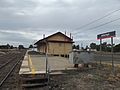
Mitchell railway station (looking towards Roma and Toowoomba)
-
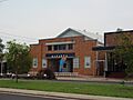
Mitchell Library, 2011
-
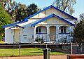
QCWA Hall in Cambridge Street
-
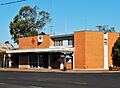
Mitchell Ambulance Station, 2019
